Property Record
N Main St, Chagrin Falls, OH 44022
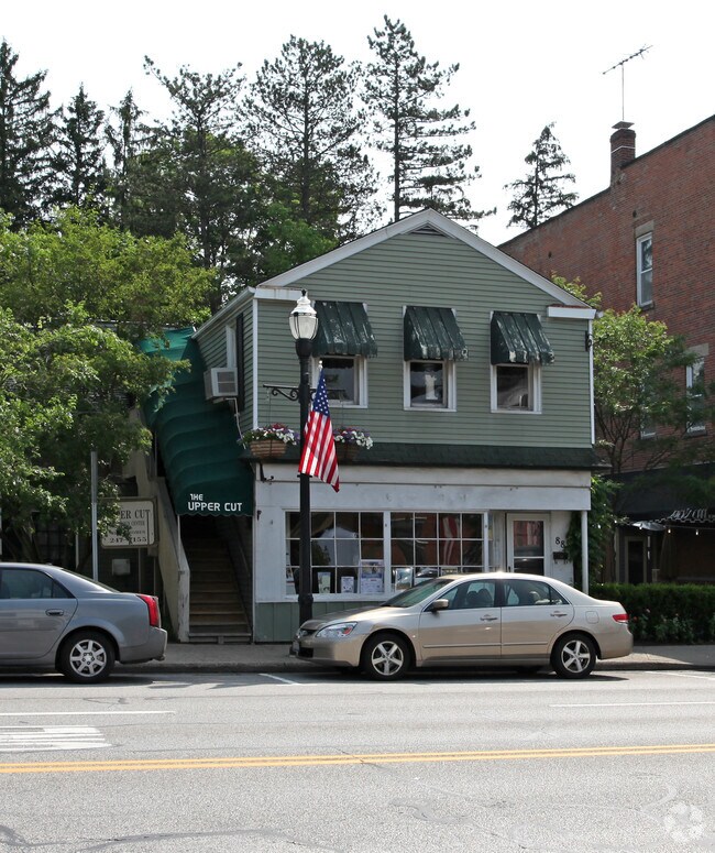
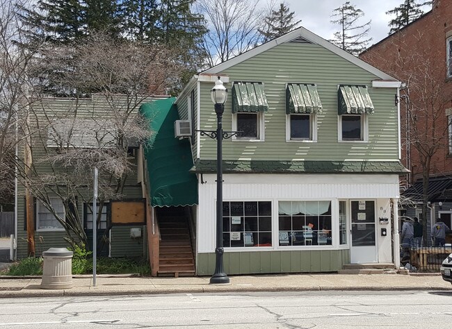
Property Detail
N Main St
Cleveland-Elyria, OH
GRAVES 0073 NWC
931-13-071
CUYAHOGA
Storesoffices
Ohio
CS
73
B and X Area of moderate flood hazard, usually the area between the limits of the 100-year and 500-year floods.
0.04 AC
2025
Southeast
2025
Cleveland
196300
NEARBY LISTINGS FOR SALE OR LEASE
DEMOGRAPHICS near N Main St
1 mile
3 mile
5 mile
2025 Total Population
4,667
18,914
50,872
2030 Population
4,672
18,894
50,653
Pop Growth 2025-2030
+ 0.11%
(0.11%)
(0.43%)
Average Age
45
45
45
2025 Total Households
2,079
7,316
19,137
HH Growth 2025-2030
+ 0.05%
(0.11%)
(0.45%)
Median Household Inc
$101,953
$145,496
$143,763
Avg Household Size
2.20
2.50
2.60
2025 Avg HH Vehicles
2.00
2.00
2.00
Median Home Value
$438,703
$473,834
$452,929
Median Year Built
1955
1967
1972
Nearby Places
Map Layers
Map Styles
 Street
 Aerial
Layers
 Traffic
 Biking
Places
Listings with unknown addresses are not visible on the map
- Restaurants
- Banks
- Shops
- Fitness
- Groceries
PUBLIC TRANSPORTATION
AIRPORT
Cleveland-Hopkins International
Drive
Walk
Distance
Cleveland-Hopkins International
41 min
26.1 mi
Freight Ports
Port of Toledo
Drive
Walk
Distance
Port of Toledo
155 min
127.1 mi
SALE & LEASE HISTORY
LISTING DATE
SALE/LEASE

May 21, 2018
For Lease
Nearby Properties
Address
Land Use
TOTAL SIZE
Lot Size
Zoning
Address
Land Use
TOTAL SIZE
Lot Size
Zoning
7,531 SF
85.32 AC
R3A
Address
Land Use
TOTAL SIZE
Lot Size
Zoning
255.11 AC
U-1
Address
Land Use
TOTAL SIZE
Lot Size
Zoning
225,206 SF
55.30 AC
PI
Address
Land Use
TOTAL SIZE
Lot Size
Zoning
75,275 SF
86.23 AC
U-2
Address
Land Use
TOTAL SIZE
Lot Size
Zoning
240,046 SF
28.85 AC
U-1
Address
Land Use
TOTAL SIZE
Lot Size
Zoning
209,977 SF
30.40 AC
U-2
Address
Land Use
TOTAL SIZE
Lot Size
Zoning
441.72 AC
1F-2
Address
Land Use
TOTAL SIZE
Lot Size
Zoning
97,536 SF
29 AC
U-1
Address
Land Use
TOTAL SIZE
Lot Size
Zoning
176.15 AC
U1
Address
Land Use
TOTAL SIZE
Lot Size
Zoning
17,684 SF
16.61 AC
Address
Land Use
TOTAL SIZE
Lot Size
Zoning
42,274 SF
48.61 AC
U-1
Address
Land Use
TOTAL SIZE
Lot Size
Zoning
52,152 SF
2.83 AC
U-3
Address
Land Use
TOTAL SIZE
Lot Size
Zoning
75,275 SF
64.40 AC
U-2
Address
Land Use
TOTAL SIZE
Lot Size
Zoning
50,867 SF
212.96 AC
U-4
Address
Land Use
TOTAL SIZE
Lot Size
Zoning
48,074 SF
9.97 AC
U-2
Address
Land Use
TOTAL SIZE
Lot Size
Zoning
93,610 SF
4.45 AC
RL
Address
Land Use
TOTAL SIZE
Lot Size
Zoning
41,235 SF
4.60 AC
U-4
Address
Land Use
TOTAL SIZE
Lot Size
Zoning
77,296 SF
3.33 AC
RB
Address
Land Use
TOTAL SIZE
Lot Size
Zoning
41,538 SF
55.43 AC
U-4
Address
Land Use
TOTAL SIZE
Lot Size
Zoning
130 AC
U-1
Address
Land Use
TOTAL SIZE
Lot Size
Zoning
76.89 AC
U-1
Address
Land Use
TOTAL SIZE
Lot Size
Zoning
27,373 SF
14.65 AC
R-1-D
Address
Land Use
TOTAL SIZE
Lot Size
Zoning
775 SF
124 AC
U-1
Address
Land Use
TOTAL SIZE
Lot Size
Zoning
86,896 SF
1.55 AC
PI
Address
Land Use
TOTAL SIZE
Lot Size
Zoning
58,075 SF
10.63 AC
PI
Address
Land Use
TOTAL SIZE
Lot Size
Zoning
7,510 SF
6.97 AC
U-1
Address
Land Use
TOTAL SIZE
Lot Size
Zoning
49,644 SF
24.96 AC
R-1-D
Address
Land Use
TOTAL SIZE
Lot Size
Zoning
418,553 SF
40.99 AC
Address
Land Use
TOTAL SIZE
Lot Size
Zoning
21,241 SF
2.69 AC
U-2
Address
Land Use
TOTAL SIZE
Lot Size
Zoning
23,354 SF
30 AC
U-1
The World's #1 Commercial Real Estate Marketplace
Connect with us
© 2026 CoStar Group
The information above has been obtained from sources believed reliable. While we do not doubt its accuracy we have not verified it and make no guarantee, warranty or representation about it. It is your responsibility to independently confirm its accuracy and completeness. Any projections, opinions, assumptions, or estimates used are for example only and do not represent the current or future performance of the property. The value of this transaction to you depends on tax and other factors which should be evaluated by your tax, financial, and legal advisors. You and your advisors should conduct a careful, independent investigation of the property to determine to your satisfaction the suitability of the property for your needs.