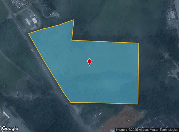
Property Record
N Main St, Cleveland, GA 30528

NEARBY LISTINGS FOR SALE OR LEASE
Property Detail
N Main St
047A-024
LL36 LD2
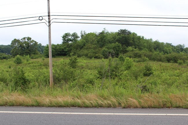
Residentialacreage
White
X
Georgia
13139C0025G
16.97 AC
0
Georgia Northeast
2025
Other Market Areas
950206
DEMOGRAPHICS near N Main St
1 Mile
3 Mile
5 Mile
2024 Total Population
2,084
7,336
15,477
2029 Population
2,250
7,933
16,755
Pop Growth 2024-2029
+ 7.97%
+ 8.14%
+ 8.26%
Average Age
35
40
42
2024 Total Households
642
2,720
5,882
HH Growth 2024-2029
+ 8.10%
+ 7.90%
+ 7.94%
Median Household Inc
$65,393
$58,946
$59,706
Avg Household Size
2.50
2.50
2.50
2024 Avg HH Vehicles
2.00
2.00
2.00
Median Home Value
$252,515
$231,101
$230,056
Median Year Built
1991
1994
1994
Nearby Places
Map Layers
Map Styles
 Street
 Aerial
- Restaurants
- Banks
- Shops
- Fitness
- Groceries
SALE & LEASE HISTORY
LISTING DATE
SALE/LEASE

Aug 15, 2017
For Sale
Nearby Properties
Address
Land Use
TOTAL SIZE
Lot Size
Zoning
Address
Land Use
TOTAL SIZE
Lot Size
Zoning
132,735 SF
51.42 AC
A1
Address
Land Use
TOTAL SIZE
Lot Size
Zoning
121,998 SF
24 AC
INST
Address
Land Use
TOTAL SIZE
Lot Size
Zoning
Address
Land Use
TOTAL SIZE
Lot Size
Zoning
71,944 SF
95.64 AC
A1
Address
Land Use
TOTAL SIZE
Lot Size
Zoning
10,168 SF
14.79 AC
C2
Address
Land Use
TOTAL SIZE
Lot Size
Zoning
3,408 SF
239.79 AC
A1
Address
Land Use
TOTAL SIZE
Lot Size
Zoning
Address
Land Use
TOTAL SIZE
Lot Size
Zoning
32,078 SF
3.07 AC
C2
Address
Land Use
TOTAL SIZE
Lot Size
Zoning
61,492 SF
8.07 AC
INST
Address
Land Use
TOTAL SIZE
Lot Size
Zoning
3,752 SF
1,028.74 AC
A1
Address
Land Use
TOTAL SIZE
Lot Size
Zoning
40,000 SF
16.99 AC
I1
Address
Land Use
TOTAL SIZE
Lot Size
Zoning
624 SF
65 AC
A1
Address
Land Use
TOTAL SIZE
Lot Size
Zoning
64,016 SF
14.47 AC
B2
Address
Land Use
TOTAL SIZE
Lot Size
Zoning
21,839 SF
5.08 AC
R1
Address
Land Use
TOTAL SIZE
Lot Size
Zoning
163,722 SF
29.40 AC
B2
Address
Land Use
TOTAL SIZE
Lot Size
Zoning
Address
Land Use
TOTAL SIZE
Lot Size
Zoning
9,120 SF
2.11 AC
A1
Address
Land Use
TOTAL SIZE
Lot Size
Zoning
18,758 SF
1.22 AC
B1
Address
Land Use
TOTAL SIZE
Lot Size
Zoning
8,338 SF
4.53 AC
C2
Address
Land Use
TOTAL SIZE
Lot Size
Zoning
866 SF
4.99 AC
R2
Address
Land Use
TOTAL SIZE
Lot Size
Zoning
12,166 SF
3.89 AC
B2
Address
Land Use
TOTAL SIZE
Lot Size
Zoning
16,478 SF
39.13 AC
A1
Address
Land Use
TOTAL SIZE
Lot Size
Zoning
Address
Land Use
TOTAL SIZE
Lot Size
Zoning
Address
Land Use
TOTAL SIZE
Lot Size
Zoning
Address
Land Use
TOTAL SIZE
Lot Size
Zoning
7,408 SF
3.65 AC
B2
Address
Land Use
TOTAL SIZE
Lot Size
Zoning
51,590 SF
11.28 AC
B2
Address
Land Use
TOTAL SIZE
Lot Size
Zoning
11,828 SF
4.46 AC
B1
Address
Land Use
TOTAL SIZE
Lot Size
Zoning
25,859 SF
57.70 AC
C1
Address
Land Use
TOTAL SIZE
Lot Size
Zoning
18,225 SF
2.99 AC
B2
The World's #1 Commercial Real Estate Marketplace
Connect with us
© 2026 CoStar Group
The information above has been obtained from sources believed reliable. While we do not doubt its accuracy we have not verified it and make no guarantee, warranty or representation about it. It is your responsibility to independently confirm its accuracy and completeness. Any projections, opinions, assumptions, or estimates used are for example only and do not represent the current or future performance of the property. The value of this transaction to you depends on tax and other factors which should be evaluated by your tax, financial, and legal advisors. You and your advisors should conduct a careful, independent investigation of the property to determine to your satisfaction the suitability of the property for your needs.