Property Record
N Mathilda Ave, Sunnyvale, CA 94089

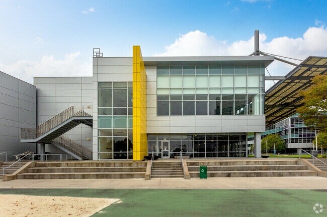

Property Detail
N Mathilda Ave
San Jose-Sunnyvale-Santa Clara, CA
LOT 3
110-44-004
SANTA CLARA
Financialbuilding
California
MPI
3
AE The base floodplain where base flood elevations are provided. AE Zones are now used on new format FIRMs instead of A1-A30 Zones.
0.84 AC
2024
Moffett Park
2025
South Bay/San Jose
504805
NEARBY LISTINGS FOR SALE OR LEASE
DEMOGRAPHICS near N Mathilda Ave
1 mile
3 mile
5 mile
2025 Total Population
58
81,609
314,018
2030 Population
57
84,464
324,320
Pop Growth 2025-2030
(1.72%)
+ 3.50%
+ 3.28%
Average Age
37
38
38
2025 Total Households
20
32,219
122,058
HH Growth 2025-2030
0.00%
+ 3.56%
+ 3.37%
Median Household Inc
$220,000
$169,872
$186,217
Avg Household Size
2.90
2.50
2.50
2025 Avg HH Vehicles
2.00
2.00
2.00
Median Home Value
$1,085,714
$1,060,451
$1,106,578
Median Year Built
2002
1985
1978
Nearby Places
Map Layers
Map Styles
 Street
 Aerial
Transit
 Traffic
 Biking
Places
Listings with unknown addresses are not visible on the map
- Restaurants
- Banks
- Shops
- Fitness
- Groceries
PUBLIC TRANSPORTATION
TRANSIT/SUBWAY
Lockheed Martin Station (Mountain View - Alum Rock - VTA, Mountain View - Alum Rock Modified-W - VTA, Mountain View - Winchester Line - VTA)
Drive
Walk
Distance
Lockheed Martin Station (Mountain View - Alum Rock - VTA, Mountain View - Alum Rock Modified-W - VTA, Mountain View - Winchester Line - VTA)
3 min
13 min
0.7 mi
Borregas Station (Mountain View - Alum Rock - VTA, Mountain View - Alum Rock Modified-W - VTA)
Drive
Walk
Distance
Borregas Station (Mountain View - Alum Rock - VTA, Mountain View - Alum Rock Modified-W - VTA)
3 min
15 min
0.8 mi
COMMUTER RAIL
Sunnyvale Caltrain Station Southbound (Express - Caltrain (Caltrain), Limited - Caltrain (Caltrain), Local Weekday - Caltrain (Caltrain), Local Weekend - Caltrain (Caltrain))
Drive
Walk
Distance
Sunnyvale Caltrain Station Southbound (Express - Caltrain (Caltrain), Limited - Caltrain (Caltrain), Local Weekday - Caltrain (Caltrain), Local Weekend - Caltrain (Caltrain))
8 min
3.5 mi
Great America-Santa Clara (ACE Train - Capitol Corridor Joint Powers Authority, Capitol Corridor - Capitol Corridor Joint Powers Authority)
Drive
Walk
Distance
Great America-Santa Clara (ACE Train - Capitol Corridor Joint Powers Authority, Capitol Corridor - Capitol Corridor Joint Powers Authority)
10 min
5.5 mi
AIRPORT
Norman Y Mineta San Jose International
Drive
Walk
Distance
Norman Y Mineta San Jose International
14 min
8.4 mi
San Francisco International
Drive
Walk
Distance
San Francisco International
37 min
28.1 mi
Metro Oakland International
Drive
Walk
Distance
Metro Oakland International
48 min
36.8 mi
Freight Ports
Port of Redwood City
Drive
Walk
Distance
Port of Redwood City
22 min
15.0 mi
Nearby Properties
Address
Land Use
TOTAL SIZE
Lot Size
Zoning
Address
Land Use
TOTAL SIZE
Lot Size
Zoning
777,000 SF
17.84 AC
MS
Address
Land Use
TOTAL SIZE
Lot Size
Zoning
499,360 SF
31.95 AC
MM40
Address
Land Use
TOTAL SIZE
Lot Size
Zoning
424,316 SF
22.37 AC
SU
Address
Land Use
TOTAL SIZE
Lot Size
Zoning
1,640,399 SF
101.23 AC
MP-I
Address
Land Use
TOTAL SIZE
Lot Size
Zoning
318,172 SF
60.47 AC
MP-TO
Address
Land Use
TOTAL SIZE
Lot Size
Zoning
355,490 SF
26.49 AC
P39
Address
Land Use
TOTAL SIZE
Lot Size
Zoning
440,173 SF
25.33 AC
P39
Address
Land Use
TOTAL SIZE
Lot Size
Zoning
73,425 SF
14.20 AC
MS
Address
Land Use
TOTAL SIZE
Lot Size
Zoning
181,709 SF
24.01 AC
MPI
Address
Land Use
TOTAL SIZE
Lot Size
Zoning
81,250 SF
14.73 AC
MPT
Address
Land Use
TOTAL SIZE
Lot Size
Zoning
431,256 SF
12.43 AC
PPSP
Address
Land Use
TOTAL SIZE
Lot Size
Zoning
350,633 SF
1.08 AC
MPTOD
Address
Land Use
TOTAL SIZE
Lot Size
Zoning
350,633 SF
1.27 AC
MPTOD
Address
Land Use
TOTAL SIZE
Lot Size
Zoning
23.19 AC
MP-I
Address
Land Use
TOTAL SIZE
Lot Size
Zoning
350,633 SF
1.08 AC
MPTOD
Address
Land Use
TOTAL SIZE
Lot Size
Zoning
353,745 SF
14.82 AC
PPSP
Address
Land Use
TOTAL SIZE
Lot Size
Zoning
17.25 AC
MPI
Address
Land Use
TOTAL SIZE
Lot Size
Zoning
23,709 SF
7.48 AC
PPSP
Address
Land Use
TOTAL SIZE
Lot Size
Zoning
22,400 SF
11.43 AC
MP-TO
Address
Land Use
TOTAL SIZE
Lot Size
Zoning
350,633 SF
1.27 AC
MPTOD
Address
Land Use
TOTAL SIZE
Lot Size
Zoning
350,633 SF
1.27 AC
MPTOD
Address
Land Use
TOTAL SIZE
Lot Size
Zoning
312,510 SF
23.46 AC
P41
Address
Land Use
TOTAL SIZE
Lot Size
Zoning
314,352 SF
0.95 AC
MP-TO
Address
Land Use
TOTAL SIZE
Lot Size
Zoning
314,352 SF
0.91 AC
MPTOD
Address
Land Use
TOTAL SIZE
Lot Size
Zoning
314,352 SF
0.94 AC
MP-TO
Address
Land Use
TOTAL SIZE
Lot Size
Zoning
288,259 SF
0.94 AC
MP-TO
Address
Land Use
TOTAL SIZE
Lot Size
Zoning
63,131 SF
4.73 AC
P41
Address
Land Use
TOTAL SIZE
Lot Size
Zoning
287,644 SF
10.04 AC
PPSP
Address
Land Use
TOTAL SIZE
Lot Size
Zoning
203,098 SF
7.90 AC
PPSP
Address
Land Use
TOTAL SIZE
Lot Size
Zoning
340,913 SF
15.64 AC
ML
The World's #1 Commercial Real Estate Marketplace
Connect with us
© 2026 CoStar Group
The information above has been obtained from sources believed reliable. While we do not doubt its accuracy we have not verified it and make no guarantee, warranty or representation about it. It is your responsibility to independently confirm its accuracy and completeness. Any projections, opinions, assumptions, or estimates used are for example only and do not represent the current or future performance of the property. The value of this transaction to you depends on tax and other factors which should be evaluated by your tax, financial, and legal advisors. You and your advisors should conduct a careful, independent investigation of the property to determine to your satisfaction the suitability of the property for your needs.