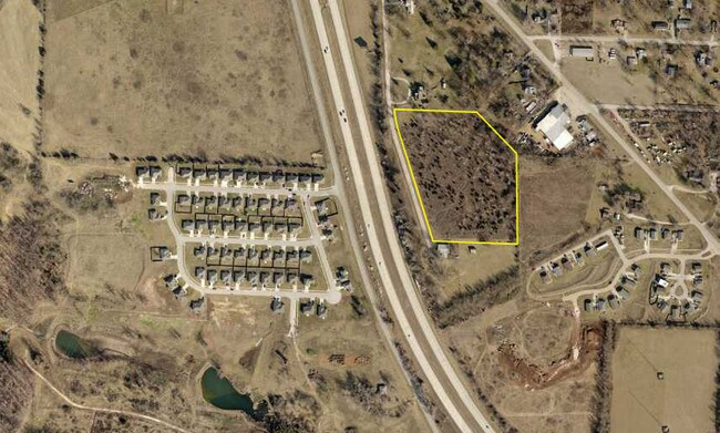
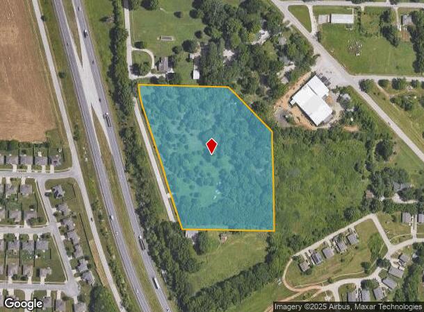
Property Record
N Old Bolivar Rd, Springfield, MO 65803
NEARBY LISTINGS FOR SALE OR LEASE
Property Detail
N Old Bolivar Rd
Springfield, MO
Montgomery Revised
13-03-206-019
MONTGOMERY REVISED ADD LOTS 11 TO & INC LOT 13 & S 37 FT LOT 10
Residentialacreage
Greene
X
Missouri
29077C0214E
13&s
2025
7.23 AC
2025
Outlying Greene County
004402
Springfield
DEMOGRAPHICS near N Old Bolivar Rd
1 Mile
3 Mile
5 Mile
2024 Total Population
1,756
24,055
81,444
2029 Population
1,802
25,043
84,743
Pop Growth 2024-2029
+ 2.62%
+ 4.11%
+ 4.05%
Average Age
39
40
37
2024 Total Households
683
10,012
33,584
HH Growth 2024-2029
+ 2.64%
+ 4.30%
+ 4.31%
Median Household Inc
$79,297
$46,460
$40,836
Avg Household Size
2.50
2.30
2.20
2024 Avg HH Vehicles
2.00
2.00
2.00
Median Home Value
$201,980
$141,980
$124,108
Median Year Built
1993
1978
1974
Nearby Places
Map Layers
Map Styles
 Street
 Aerial
- Restaurants
- Banks
- Shops
- Fitness
- Groceries
PUBLIC TRANSPORTATION
AIRPORT
Springfield-Branson Ntl
DRIVE
WALK
Distance
Springfield-Branson Ntl
20 min
10.9 mi
Freight Ports
Tulsa Port of Inola
DRIVE
WALK
Distance
Tulsa Port of Inola
193 min
173.3 mi
SALE & LEASE HISTORY
LISTING DATE
SALE/LEASE

Nov 19, 2019
For Sale
Mar 30, 2017
For Sale
Nearby Properties
Address
Land Use
TOTAL SIZE
Lot Size
Zoning
Address
Land Use
TOTAL SIZE
Lot Size
Zoning
234,926 SF
9.41 AC
INC
Address
Land Use
TOTAL SIZE
Lot Size
Zoning
186,125 SF
21.09 AC
INC
Address
Land Use
TOTAL SIZE
Lot Size
Zoning
93,916 SF
7.91 AC
INC
Address
Land Use
TOTAL SIZE
Lot Size
Zoning
29.42 AC
INC
Address
Land Use
TOTAL SIZE
Lot Size
Zoning
136,629 SF
26.79 AC
INC
Address
Land Use
TOTAL SIZE
Lot Size
Zoning
10.76 AC
INC
Address
Land Use
TOTAL SIZE
Lot Size
Zoning
16.08 AC
Address
Land Use
TOTAL SIZE
Lot Size
Zoning
75.07 AC
INC
Address
Land Use
TOTAL SIZE
Lot Size
Zoning
Address
Land Use
TOTAL SIZE
Lot Size
Zoning
Address
Land Use
TOTAL SIZE
Lot Size
Zoning
78,239 SF
10.01 AC
INC
Address
Land Use
TOTAL SIZE
Lot Size
Zoning
Address
Land Use
TOTAL SIZE
Lot Size
Zoning
55,568 SF
2.13 AC
INC
Address
Land Use
TOTAL SIZE
Lot Size
Zoning
90,928 SF
5.36 AC
INC
Address
Land Use
TOTAL SIZE
Lot Size
Zoning
3,640 SF
22.50 AC
INC
Address
Land Use
TOTAL SIZE
Lot Size
Zoning
267,740 SF
26.80 AC
M-1
Address
Land Use
TOTAL SIZE
Lot Size
Zoning
27,871 SF
4.81 AC
INC
Address
Land Use
TOTAL SIZE
Lot Size
Zoning
69,401 SF
4.63 AC
INC
Address
Land Use
TOTAL SIZE
Lot Size
Zoning
105,785 SF
16.75 AC
INC
Address
Land Use
TOTAL SIZE
Lot Size
Zoning
12,547 SF
42.87 AC
INC
Address
Land Use
TOTAL SIZE
Lot Size
Zoning
30,131 SF
2.51 AC
INC
Address
Land Use
TOTAL SIZE
Lot Size
Zoning
29,929 SF
7.30 AC
INC
Address
Land Use
TOTAL SIZE
Lot Size
Zoning
14.04 AC
INC
Address
Land Use
TOTAL SIZE
Lot Size
Zoning
55,093 SF
6.10 AC
INC
Address
Land Use
TOTAL SIZE
Lot Size
Zoning
58,359 SF
2.89 AC
INC
Address
Land Use
TOTAL SIZE
Lot Size
Zoning
34,164 SF
7.70 AC
INC
Address
Land Use
TOTAL SIZE
Lot Size
Zoning
13.96 AC
INC
Address
Land Use
TOTAL SIZE
Lot Size
Zoning
23,992 SF
2.38 AC
INC
Address
Land Use
TOTAL SIZE
Lot Size
Zoning
57,928 SF
10.80 AC
INC
Address
Land Use
TOTAL SIZE
Lot Size
Zoning
24,753 SF
13.05 AC
INC
The World's #1 Commercial Real Estate Marketplace
Connect with us
© 2026 CoStar Group
The information above has been obtained from sources believed reliable. While we do not doubt its accuracy we have not verified it and make no guarantee, warranty or representation about it. It is your responsibility to independently confirm its accuracy and completeness. Any projections, opinions, assumptions, or estimates used are for example only and do not represent the current or future performance of the property. The value of this transaction to you depends on tax and other factors which should be evaluated by your tax, financial, and legal advisors. You and your advisors should conduct a careful, independent investigation of the property to determine to your satisfaction the suitability of the property for your needs.