Property Record
N Otter Creek Rd, Monroe, MI 48161


NEARBY LISTINGS FOR SALE OR LEASE
-
-
View all Monroe listings for sale on LoopNet.com
Property Detail
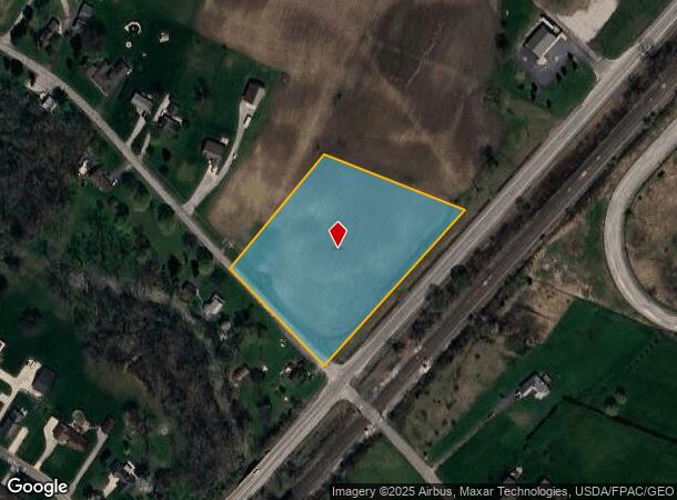
N Otter Creek Rd
Monroe, MI
Otter Creek
09-130-181-03
SPLIT ON 01/06/2017 FROM 09 130 181 00; PT OF FRACTIONAL SEC 15 T7S R8E, COMM AT THE SW CORNER OF PC 511; TH S 25 DEG 00' W
Residentialacreage
Monroe
X
Michigan
26115C0377F
3.92 AC
2024
Monroe County
2025
Detroit
832200
DEMOGRAPHICS near N Otter Creek Rd
1 Mile
3 Mile
5 Mile
2024 Total Population
749
11,419
41,655
2029 Population
758
11,596
42,293
Pop Growth 2024-2029
+ 1.20%
+ 1.55%
+ 1.53%
Average Age
45
44
42
2024 Total Households
296
4,671
16,935
HH Growth 2024-2029
+ 1.01%
+ 1.48%
+ 1.46%
Median Household Inc
$59,332
$64,731
$59,400
Avg Household Size
2.50
2.40
2.30
2024 Avg HH Vehicles
2.00
2.00
2.00
Median Home Value
$214,024
$210,099
$171,574
Median Year Built
1960
1975
1967
Nearby Places
Map Layers
Map Styles
 Street
 Aerial
- Restaurants
- Banks
- Shops
- Fitness
- Groceries
PUBLIC TRANSPORTATION
AIRPORT
Detroit Metro Wayne County
DRIVE
WALK
Distance
Detroit Metro Wayne County
37 min
27.6 mi
Eugene F Kranz Toledo Express
DRIVE
WALK
Distance
Eugene F Kranz Toledo Express
55 min
36.0 mi
Freight Ports
Port of Toledo
DRIVE
WALK
Distance
Port of Toledo
31 min
20.2 mi
SALE & LEASE HISTORY
LISTING DATE
SALE/LEASE

Sep 24, 2016
For Sale
Nov 07, 2023
For Sale
Nearby Properties
Address
Land Use
TOTAL SIZE
Lot Size
Zoning
Address
Land Use
TOTAL SIZE
Lot Size
Zoning
97.18 AC
Address
Land Use
TOTAL SIZE
Lot Size
Zoning
109,073 SF
47.32 AC
Address
Land Use
TOTAL SIZE
Lot Size
Zoning
183,508 SF
70 AC
Address
Land Use
TOTAL SIZE
Lot Size
Zoning
13.60 AC
Address
Land Use
TOTAL SIZE
Lot Size
Zoning
43,528 SF
16.06 AC
MHP
Address
Land Use
TOTAL SIZE
Lot Size
Zoning
104,117 SF
12.04 AC
Address
Land Use
TOTAL SIZE
Lot Size
Zoning
40,476 SF
18.60 AC
Address
Land Use
TOTAL SIZE
Lot Size
Zoning
11,420 SF
200.20 AC
Address
Land Use
TOTAL SIZE
Lot Size
Zoning
73,356 SF
6.23 AC
Address
Land Use
TOTAL SIZE
Lot Size
Zoning
24,854 SF
10.30 AC
Address
Land Use
TOTAL SIZE
Lot Size
Zoning
57,560 SF
11.30 AC
Address
Land Use
TOTAL SIZE
Lot Size
Zoning
23,133 SF
4.57 AC
Address
Land Use
TOTAL SIZE
Lot Size
Zoning
4,495 SF
20.93 AC
MHP
Address
Land Use
TOTAL SIZE
Lot Size
Zoning
336 SF
20.93 AC
MHP
Address
Land Use
TOTAL SIZE
Lot Size
Zoning
10,791 SF
10.77 AC
Address
Land Use
TOTAL SIZE
Lot Size
Zoning
38,500 SF
3 AC
Address
Land Use
TOTAL SIZE
Lot Size
Zoning
35,362 SF
52.08 AC
Address
Land Use
TOTAL SIZE
Lot Size
Zoning
20,354 SF
4.99 AC
Address
Land Use
TOTAL SIZE
Lot Size
Zoning
17,193 SF
3.73 AC
Address
Land Use
TOTAL SIZE
Lot Size
Zoning
26,120 SF
8.37 AC
Address
Land Use
TOTAL SIZE
Lot Size
Zoning
35,696 SF
5.26 AC
Address
Land Use
TOTAL SIZE
Lot Size
Zoning
3,968 SF
39.79 AC
Address
Land Use
TOTAL SIZE
Lot Size
Zoning
16,107 SF
4.74 AC
Address
Land Use
TOTAL SIZE
Lot Size
Zoning
20,785 SF
1.22 AC
Address
Land Use
TOTAL SIZE
Lot Size
Zoning
5,776 SF
36.34 AC
Address
Land Use
TOTAL SIZE
Lot Size
Zoning
24.48 AC
Address
Land Use
TOTAL SIZE
Lot Size
Zoning
6,900 SF
0.97 AC
Address
Land Use
TOTAL SIZE
Lot Size
Zoning
11,250 SF
1 AC
Address
Land Use
TOTAL SIZE
Lot Size
Zoning
3,800 SF
1.14 AC
Address
Land Use
TOTAL SIZE
Lot Size
Zoning
6,510 SF
1.01 AC
The World's #1 Commercial Real Estate Marketplace
Connect with us
© 2025 CoStar Group
The information above has been obtained from sources believed reliable. While we do not doubt its accuracy we have not verified it and make no guarantee, warranty or representation about it. It is your responsibility to independently confirm its accuracy and completeness. Any projections, opinions, assumptions, or estimates used are for example only and do not represent the current or future performance of the property. The value of this transaction to you depends on tax and other factors which should be evaluated by your tax, financial, and legal advisors. You and your advisors should conduct a careful, independent investigation of the property to determine to your satisfaction the suitability of the property for your needs.