Property Record
N Pine Rd, Rosharon, TX 77583

Save to a Folder
{{folder.Name}}
{{folder.ListingIds.length}} Properties
{{folder.ListingIds.length}} Property
Create a New Folder
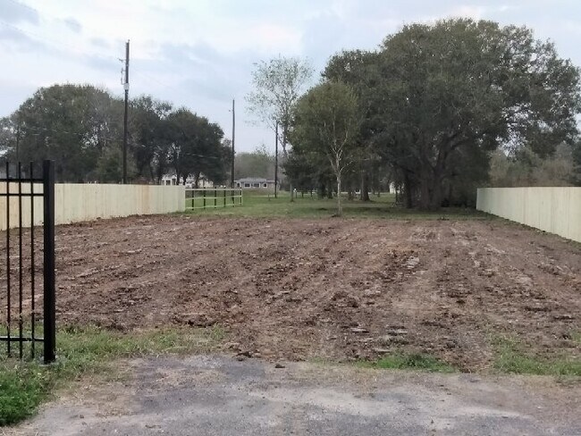
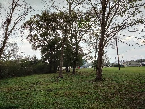
Property Detail
N Pine Rd
Houston-Pasadena-The Woodlands, TX
ARCOLA FARMS, BLOCK 2, LOT 40, ACRES 1
1150-00-002-4201-907
FORT BEND
Residentialacreage
Texas
A Areas with a 1% annual chance of flooding and a 26% chance of flooding over the life of a 30-year mortgage.
40
2024
1.01 AC
2025
Southwest Outlier
661902
Houston
NEARBY LISTINGS FOR SALE OR LEASE
DEMOGRAPHICS near N Pine Rd
1 mile
3 mile
5 mile
2025 Total Population
3,830
52,037
133,967
2030 Population
4,504
59,610
152,791
Pop Growth 2025-2030
+ 17.60%
+ 14.55%
+ 14.05%
Average Age
33
35
35
2025 Total Households
1,092
15,736
41,092
HH Growth 2025-2030
+ 17.95%
+ 14.90%
+ 14.39%
Median Household Inc
$81,139
$97,291
$117,687
Avg Household Size
3.40
3.30
3.20
2025 Avg HH Vehicles
2.00
2.00
2.00
Median Home Value
$246,168
$305,825
$362,104
Median Year Built
2007
2009
2010
Nearby Places
Map Layers
Map Styles
 Street
 Aerial
Layers
 Traffic
 Biking
Places
Listings with unknown addresses are not visible on the map
- Restaurants
- Banks
- Shops
- Fitness
- Groceries
PUBLIC TRANSPORTATION
AIRPORT
William P Hobby
Drive
Walk
Distance
William P Hobby
36 min
20.4 mi
Freight Ports
Port of Houston
Drive
Walk
Distance
Port of Houston
41 min
24.9 mi
SALE & LEASE HISTORY
LISTING DATE
SALE/LEASE

May 09, 2022
For Sale
Nearby Properties
Address
Land Use
TOTAL SIZE
Lot Size
Zoning
Address
Land Use
TOTAL SIZE
Lot Size
Zoning
Address
Land Use
TOTAL SIZE
Lot Size
Zoning
1,764 SF
39.64 AC
ST
Address
Land Use
TOTAL SIZE
Lot Size
Zoning
82,400 SF
10.85 AC
I
Address
Land Use
TOTAL SIZE
Lot Size
Zoning
15.28 AC
0015
Address
Land Use
TOTAL SIZE
Lot Size
Zoning
537.89 AC
Address
Land Use
TOTAL SIZE
Lot Size
Zoning
127,500 SF
7.60 AC
Address
Land Use
TOTAL SIZE
Lot Size
Zoning
105,790 SF
12.82 AC
X
Address
Land Use
TOTAL SIZE
Lot Size
Zoning
13.85 AC
Address
Land Use
TOTAL SIZE
Lot Size
Zoning
70,000 SF
64.91 AC
Address
Land Use
TOTAL SIZE
Lot Size
Zoning
2,000 SF
24.85 AC
Address
Land Use
TOTAL SIZE
Lot Size
Zoning
28,633 SF
9.36 AC
Address
Land Use
TOTAL SIZE
Lot Size
Zoning
224.26 AC
Address
Land Use
TOTAL SIZE
Lot Size
Zoning
4.30 AC
Address
Land Use
TOTAL SIZE
Lot Size
Zoning
75,548 SF
12.30 AC
Address
Land Use
TOTAL SIZE
Lot Size
Zoning
17,481 SF
12.54 AC
Address
Land Use
TOTAL SIZE
Lot Size
Zoning
37,000 SF
6.06 AC
0218
Address
Land Use
TOTAL SIZE
Lot Size
Zoning
Address
Land Use
TOTAL SIZE
Lot Size
Zoning
114,723 SF
20.13 AC
0007
Address
Land Use
TOTAL SIZE
Lot Size
Zoning
2.92 AC
Address
Land Use
TOTAL SIZE
Lot Size
Zoning
91.43 AC
SQ
Address
Land Use
TOTAL SIZE
Lot Size
Zoning
2.31 AC
S
Address
Land Use
TOTAL SIZE
Lot Size
Zoning
7.86 AC
SN
Address
Land Use
TOTAL SIZE
Lot Size
Zoning
13,134 SF
2.08 AC
Address
Land Use
TOTAL SIZE
Lot Size
Zoning
70,260 SF
4.41 AC
SY
Address
Land Use
TOTAL SIZE
Lot Size
Zoning
36,504 SF
10 AC
0031
Address
Land Use
TOTAL SIZE
Lot Size
Zoning
16,512 SF
3.04 AC
Address
Land Use
TOTAL SIZE
Lot Size
Zoning
20,770 SF
2.93 AC
XY
Address
Land Use
TOTAL SIZE
Lot Size
Zoning
14,543 SF
2.22 AC
Address
Land Use
TOTAL SIZE
Lot Size
Zoning
19,305 SF
1.99 AC
XS
Address
Land Use
TOTAL SIZE
Lot Size
Zoning
2.63 AC
The World's #1 Commercial Real Estate Marketplace
Connect with us
© 2026 CoStar Group
The information above has been obtained from sources believed reliable. While we do not doubt its accuracy we have not verified it and make no guarantee, warranty or representation about it. It is your responsibility to independently confirm its accuracy and completeness. Any projections, opinions, assumptions, or estimates used are for example only and do not represent the current or future performance of the property. The value of this transaction to you depends on tax and other factors which should be evaluated by your tax, financial, and legal advisors. You and your advisors should conduct a careful, independent investigation of the property to determine to your satisfaction the suitability of the property for your needs.