Property Record
N Prow Rd, Bloomington, IN 47404
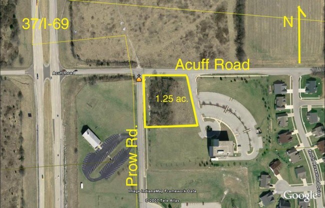

Property Detail
N Prow Rd
Bloomington, IN
013-14795-00 PARK SCHOOL CORNER PART LOT 2 1.03A
53-05-20-202-002.000-005
MONROE
Commercialacreage
Indiana
B and X Area of moderate flood hazard, usually the area between the limits of the 100-year and 500-year floods.
2
2024
1.03 AC
2025
Bloomington/Terre Haute
000700
Other Market Areas
NEARBY LISTINGS FOR SALE OR LEASE
DEMOGRAPHICS near N Prow Rd
1 mile
3 mile
5 mile
2025 Total Population
1,530
33,641
94,967
2030 Population
1,482
34,683
95,911
Pop Growth 2025-2030
(3.14%)
+ 3.10%
+ 0.99%
Average Age
44
33
34
2025 Total Households
627
14,256
38,871
HH Growth 2025-2030
(3.35%)
+ 3.42%
+ 0.97%
Median Household Inc
$88,780
$42,110
$50,720
Avg Household Size
2.30
2.10
2.10
2025 Avg HH Vehicles
2.00
2.00
2.00
Median Home Value
$264,573
$302,483
$295,895
Median Year Built
1967
1992
1989
Nearby Places
Map Layers
Map Styles
 Street
 Aerial
Layers
 Traffic
 Biking
Places
Listings with unknown addresses are not visible on the map
- Restaurants
- Banks
- Shops
- Fitness
- Groceries
Nearby Properties
Address
Land Use
TOTAL SIZE
Lot Size
Zoning
Address
Land Use
TOTAL SIZE
Lot Size
Zoning
7,804 SF
7.22 AC
Address
Land Use
TOTAL SIZE
Lot Size
Zoning
13,910 SF
3.86 AC
Address
Land Use
TOTAL SIZE
Lot Size
Zoning
79,763 SF
12.34 AC
Address
Land Use
TOTAL SIZE
Lot Size
Zoning
8,327 SF
1.64 AC
Address
Land Use
TOTAL SIZE
Lot Size
Zoning
496,556 SF
1.73 AC
Address
Land Use
TOTAL SIZE
Lot Size
Zoning
261,278 SF
4.62 AC
Address
Land Use
TOTAL SIZE
Lot Size
Zoning
10,573 SF
3.28 AC
Address
Land Use
TOTAL SIZE
Lot Size
Zoning
8,064 SF
1.29 AC
Address
Land Use
TOTAL SIZE
Lot Size
Zoning
53,005 SF
10.03 AC
PUD
Address
Land Use
TOTAL SIZE
Lot Size
Zoning
169,170 SF
0.72 AC
Address
Land Use
TOTAL SIZE
Lot Size
Zoning
181,798 SF
0.80 AC
Address
Land Use
TOTAL SIZE
Lot Size
Zoning
38,208 SF
8.03 AC
Address
Land Use
TOTAL SIZE
Lot Size
Zoning
107,519 SF
0.03 AC
Address
Land Use
TOTAL SIZE
Lot Size
Zoning
1,509 SF
3 AC
Address
Land Use
TOTAL SIZE
Lot Size
Zoning
53,205 SF
1.13 AC
Address
Land Use
TOTAL SIZE
Lot Size
Zoning
48,022 SF
0.77 AC
Address
Land Use
TOTAL SIZE
Lot Size
Zoning
78,474 SF
0.35 AC
Address
Land Use
TOTAL SIZE
Lot Size
Zoning
45,676 SF
4.18 AC
Address
Land Use
TOTAL SIZE
Lot Size
Zoning
10,573 SF
1.30 AC
Address
Land Use
TOTAL SIZE
Lot Size
Zoning
102,736 SF
Address
Land Use
TOTAL SIZE
Lot Size
Zoning
59,601 SF
2.42 AC
GB
Address
Land Use
TOTAL SIZE
Lot Size
Zoning
39,547 SF
1.30 AC
Address
Land Use
TOTAL SIZE
Lot Size
Zoning
60,184 SF
1.95 AC
Address
Land Use
TOTAL SIZE
Lot Size
Zoning
71,067 SF
0.56 AC
Address
Land Use
TOTAL SIZE
Lot Size
Zoning
112,513 SF
0.77 AC
Address
Land Use
TOTAL SIZE
Lot Size
Zoning
30,013 SF
7.86 AC
Address
Land Use
TOTAL SIZE
Lot Size
Zoning
75,012 SF
1.22 AC
Address
Land Use
TOTAL SIZE
Lot Size
Zoning
68,903 SF
1.50 AC
Address
Land Use
TOTAL SIZE
Lot Size
Zoning
9,380 SF
34.28 AC
IG
Address
Land Use
TOTAL SIZE
Lot Size
Zoning
9,798 SF
4.01 AC
The World's #1 Commercial Real Estate Marketplace
Connect with us
© 2026 CoStar Group
The information above has been obtained from sources believed reliable. While we do not doubt its accuracy we have not verified it and make no guarantee, warranty or representation about it. It is your responsibility to independently confirm its accuracy and completeness. Any projections, opinions, assumptions, or estimates used are for example only and do not represent the current or future performance of the property. The value of this transaction to you depends on tax and other factors which should be evaluated by your tax, financial, and legal advisors. You and your advisors should conduct a careful, independent investigation of the property to determine to your satisfaction the suitability of the property for your needs.