Property Record
N Pulaski Hwy, Perryville, MD 21903
NEARBY LISTINGS FOR SALE OR LEASE
Property Detail
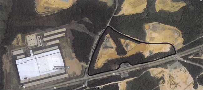
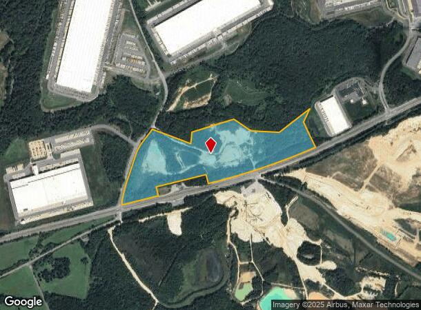
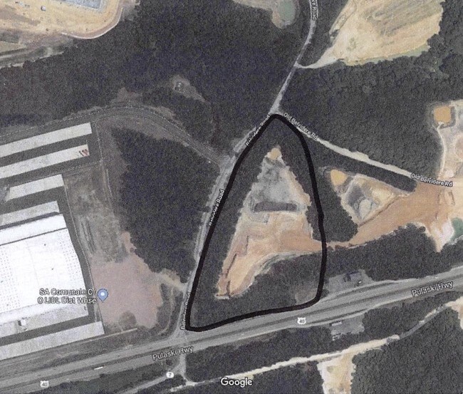
N Pulaski Hwy
Philadelphia-Camden-Wilmington, PA-NJ-DE-MD
PARCEL 1 - 57.979 AC N/S PULASKI HWY N/W OF CHARLESTOWN
05-139301
Cecil
Industrialgeneral
Maryland
AE
p1
24025C0205E
57.98 AC
2025
Cecil County
2025
Baltimore
031202
DEMOGRAPHICS near N Pulaski Hwy
1 Mile
3 Mile
5 Mile
2024 Total Population
41
7,737
31,904
2029 Population
42
7,998
32,939
Pop Growth 2024-2029
+ 2.44%
+ 3.37%
+ 3.24%
Average Age
38
40
41
2024 Total Households
17
3,079
12,836
HH Growth 2024-2029
0.00%
+ 3.57%
+ 3.39%
Median Household Inc
$95,833
$92,023
$75,517
Avg Household Size
2.30
2.50
2.40
2024 Avg HH Vehicles
2.00
2.00
2.00
Median Home Value
$299,999
$317,480
$300,407
Median Year Built
1996
1993
1986
Nearby Places
Map Layers
Map Styles
 Street
 Aerial
- Restaurants
- Banks
- Shops
- Fitness
- Groceries
PUBLIC TRANSPORTATION
COMMUTER RAIL
Perryville (PENN - WASHINGTON - Maryland Area Regional Commuter Trains (The MARC), Penn Line - Maryland Area Regional Commuter Trains (The MARC))
DRIVE
WALK
Distance
Perryville (PENN - WASHINGTON - Maryland Area Regional Commuter Trains (The MARC), Penn Line - Maryland Area Regional Commuter Trains (The MARC))
6 min
4.0 mi
Aberdeen (PENN - WASHINGTON - Maryland Area Regional Commuter Trains (The MARC), Penn Line - Maryland Area Regional Commuter Trains (The MARC))
DRIVE
WALK
Distance
Aberdeen (PENN - WASHINGTON - Maryland Area Regional Commuter Trains (The MARC), Penn Line - Maryland Area Regional Commuter Trains (The MARC))
16 min
10.0 mi
Freight Ports
Port of Wilmington, RI
DRIVE
WALK
Distance
Port of Wilmington, RI
41 min
31.8 mi
SALE & LEASE HISTORY
LISTING DATE
SALE/LEASE

Aug 06, 2019
For Sale
Nearby Properties
Address
Land Use
TOTAL SIZE
Lot Size
Zoning
Address
Land Use
TOTAL SIZE
Lot Size
Zoning
866,826 SF
267.48 AC
L2
Address
Land Use
TOTAL SIZE
Lot Size
Zoning
1,142,416 SF
95.61 AC
M2
Address
Land Use
TOTAL SIZE
Lot Size
Zoning
1,080,040 SF
127.58 AC
MEA
Address
Land Use
TOTAL SIZE
Lot Size
Zoning
521,850 SF
113.72 AC
MEA
Address
Land Use
TOTAL SIZE
Lot Size
Zoning
593,162 SF
84.15 AC
M2
Address
Land Use
TOTAL SIZE
Lot Size
Zoning
2,397 SF
72.03 AC
M2
Address
Land Use
TOTAL SIZE
Lot Size
Zoning
14,288 SF
67.19 AC
MEA
Address
Land Use
TOTAL SIZE
Lot Size
Zoning
592,800 SF
55.37 AC
M2
Address
Land Use
TOTAL SIZE
Lot Size
Zoning
1,005,768 SF
70.66 AC
M2
Address
Land Use
TOTAL SIZE
Lot Size
Zoning
89,346 SF
21.86 AC
RM
Address
Land Use
TOTAL SIZE
Lot Size
Zoning
502,200 SF
50.87 AC
M2
Address
Land Use
TOTAL SIZE
Lot Size
Zoning
360,458 SF
25.78 AC
M2
Address
Land Use
TOTAL SIZE
Lot Size
Zoning
200,100 SF
53.73 AC
Address
Land Use
TOTAL SIZE
Lot Size
Zoning
31,344 SF
5.70 AC
RM
Address
Land Use
TOTAL SIZE
Lot Size
Zoning
140,316 SF
36.71 AC
RM
Address
Land Use
TOTAL SIZE
Lot Size
Zoning
150,000 SF
7.61 AC
M2
Address
Land Use
TOTAL SIZE
Lot Size
Zoning
32,000 SF
193.70 AC
M1
Address
Land Use
TOTAL SIZE
Lot Size
Zoning
92,200 SF
14.32 AC
SPLIT
Address
Land Use
TOTAL SIZE
Lot Size
Zoning
44,138 SF
20.30 AC
Address
Land Use
TOTAL SIZE
Lot Size
Zoning
4,800 SF
14.81 AC
C2
Address
Land Use
TOTAL SIZE
Lot Size
Zoning
3.37 AC
OS
Address
Land Use
TOTAL SIZE
Lot Size
Zoning
9,440 SF
790.55 AC
MEA
Address
Land Use
TOTAL SIZE
Lot Size
Zoning
24,000 SF
2.24 AC
C2
Address
Land Use
TOTAL SIZE
Lot Size
Zoning
24,000 SF
2.16 AC
C2
Address
Land Use
TOTAL SIZE
Lot Size
Zoning
44,160 SF
5.04 AC
M2
Address
Land Use
TOTAL SIZE
Lot Size
Zoning
15,344 SF
4.96 AC
MUD
Address
Land Use
TOTAL SIZE
Lot Size
Zoning
50,000 SF
16 AC
L2
Address
Land Use
TOTAL SIZE
Lot Size
Zoning
71,490 SF
16.62 AC
M2
Address
Land Use
TOTAL SIZE
Lot Size
Zoning
149.61 AC
M2
Address
Land Use
TOTAL SIZE
Lot Size
Zoning
11,840 SF
13.53 AC
M2
The World's #1 Commercial Real Estate Marketplace
Connect with us
© 2025 CoStar Group
The information above has been obtained from sources believed reliable. While we do not doubt its accuracy we have not verified it and make no guarantee, warranty or representation about it. It is your responsibility to independently confirm its accuracy and completeness. Any projections, opinions, assumptions, or estimates used are for example only and do not represent the current or future performance of the property. The value of this transaction to you depends on tax and other factors which should be evaluated by your tax, financial, and legal advisors. You and your advisors should conduct a careful, independent investigation of the property to determine to your satisfaction the suitability of the property for your needs.