Property Record
N Rd Frontage, Fowlerville, MI 48836
NEARBY LISTINGS FOR SALE OR LEASE
Property Detail
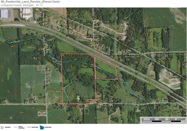
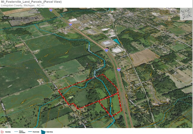
N Rd Frontage
05-24-200-005
SEC 24 T3N R3E NW 1/4 EXC I-96 HWY EXC THE W 880 FT ALSO EXC S 225 FT OF E 475 FT, 102AC
Residentialacreage
Livingston
AE
Michigan
26093C0168D
17.09 AC
2025
Livingston County
2025
Detroit
722300
Detroit-Warren-Dearborn, MI
DEMOGRAPHICS near N Rd Frontage
1 Mile
3 Mile
5 Mile
2024 Total Population
318
7,788
17,259
2029 Population
328
7,981
17,666
Pop Growth 2024-2029
+ 3.14%
+ 2.48%
+ 2.36%
Average Age
40
40
41
2024 Total Households
114
3,016
6,563
HH Growth 2024-2029
+ 2.63%
+ 2.35%
+ 2.27%
Median Household Inc
$66,818
$66,564
$76,998
Avg Household Size
2.70
2.50
2.60
2024 Avg HH Vehicles
2.00
2.00
2.00
Median Home Value
$228,571
$186,572
$227,845
Median Year Built
1994
1983
1990
Nearby Places
Map Layers
Map Styles
 Street
 Aerial
- Restaurants
- Banks
- Shops
- Fitness
- Groceries
PUBLIC TRANSPORTATION
AIRPORT
Capital Region International
DRIVE
WALK
Distance
Capital Region International
50 min
40.6 mi
Bishop International
DRIVE
WALK
Distance
Bishop International
63 min
42.0 mi
Freight Ports
Port of Toledo
DRIVE
WALK
Distance
Port of Toledo
112 min
94.7 mi
SALE & LEASE HISTORY
LISTING DATE
SALE/LEASE

Jan 30, 2023
For Sale
Nearby Properties
Address
Land Use
TOTAL SIZE
Lot Size
Zoning
Address
Land Use
TOTAL SIZE
Lot Size
Zoning
331,100 SF
41.10 AC
RSC
Address
Land Use
TOTAL SIZE
Lot Size
Zoning
196,739 SF
31.45 AC
Address
Land Use
TOTAL SIZE
Lot Size
Zoning
321,167 SF
27.01 AC
IFZ
Address
Land Use
TOTAL SIZE
Lot Size
Zoning
153,010 SF
22.06 AC
Address
Land Use
TOTAL SIZE
Lot Size
Zoning
38.64 AC
R&D
Address
Land Use
TOTAL SIZE
Lot Size
Zoning
24,644 SF
160 AC
R&D
Address
Land Use
TOTAL SIZE
Lot Size
Zoning
6,837 SF
128.76 AC
MHP
Address
Land Use
TOTAL SIZE
Lot Size
Zoning
184,160 SF
36.49 AC
Address
Land Use
TOTAL SIZE
Lot Size
Zoning
Address
Land Use
TOTAL SIZE
Lot Size
Zoning
142,638 SF
26.01 AC
Address
Land Use
TOTAL SIZE
Lot Size
Zoning
119,260 SF
7.10 AC
IFZ
Address
Land Use
TOTAL SIZE
Lot Size
Zoning
59,000 SF
12.53 AC
Address
Land Use
TOTAL SIZE
Lot Size
Zoning
107,867 SF
26.53 AC
AR
Address
Land Use
TOTAL SIZE
Lot Size
Zoning
131,333 SF
22.93 AC
AR
Address
Land Use
TOTAL SIZE
Lot Size
Zoning
Address
Land Use
TOTAL SIZE
Lot Size
Zoning
128,437 SF
8.55 AC
IFZ
Address
Land Use
TOTAL SIZE
Lot Size
Zoning
22,660 SF
4.80 AC
IFZ
Address
Land Use
TOTAL SIZE
Lot Size
Zoning
81.26 AC
MHP
Address
Land Use
TOTAL SIZE
Lot Size
Zoning
53,448 SF
5.16 AC
IFZ
Address
Land Use
TOTAL SIZE
Lot Size
Zoning
49,200 SF
36.30 AC
Address
Land Use
TOTAL SIZE
Lot Size
Zoning
13.92 AC
IFZ
Address
Land Use
TOTAL SIZE
Lot Size
Zoning
38,940 SF
Address
Land Use
TOTAL SIZE
Lot Size
Zoning
47,072 SF
2.03 AC
RSC
Address
Land Use
TOTAL SIZE
Lot Size
Zoning
45,275 SF
4 AC
AR
Address
Land Use
TOTAL SIZE
Lot Size
Zoning
34,000 SF
8 AC
MFR
Address
Land Use
TOTAL SIZE
Lot Size
Zoning
1,406 SF
340.04 AC
AR
Address
Land Use
TOTAL SIZE
Lot Size
Zoning
49,207 SF
5.39 AC
Address
Land Use
TOTAL SIZE
Lot Size
Zoning
52,720 SF
10 AC
IFZ
Address
Land Use
TOTAL SIZE
Lot Size
Zoning
40,000 SF
AR
Address
Land Use
TOTAL SIZE
Lot Size
Zoning
75,785 SF
4.87 AC
IFZ
The World's #1 Commercial Real Estate Marketplace
Connect with us
© 2025 CoStar Group
The information above has been obtained from sources believed reliable. While we do not doubt its accuracy we have not verified it and make no guarantee, warranty or representation about it. It is your responsibility to independently confirm its accuracy and completeness. Any projections, opinions, assumptions, or estimates used are for example only and do not represent the current or future performance of the property. The value of this transaction to you depends on tax and other factors which should be evaluated by your tax, financial, and legal advisors. You and your advisors should conduct a careful, independent investigation of the property to determine to your satisfaction the suitability of the property for your needs.