Property Record
N Route 29, Chillicothe, IL 61523
NEARBY LISTINGS FOR SALE OR LEASE
-
-
View all Chillicothe listings for sale on LoopNet.com
Property Detail
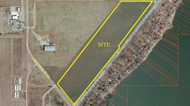
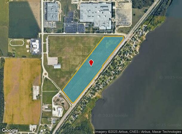
N Route 29
Peoria, IL
SEC 23-10N-8E 48.374 AC COMG NW COR SEC 23 TH S 1783.3 E 2448.21 TO POB: TH E 754.84 SE 181.86 SW 1022.29 NW 5 SW 1083 SW 100.12 SW 100.5 SW 100.12 SW 500 SW 100.5 SW 140 W 65.45 NW 656.66 NE 2700.88 TO POB (EXC COMG NW COR SEC 23 TH S
09-23-301-006
Peoria
Farms
Illinois
2024
48.37 AC
2024
Outlying Peoria County
003602
Peoria
DEMOGRAPHICS near N Route 29
1 Mile
3 Mile
5 Mile
2024 Total Population
214
6,343
27,198
2029 Population
208
6,137
26,360
Pop Growth 2024-2029
(2.80%)
(3.25%)
(3.08%)
Average Age
44
43
41
2024 Total Households
89
2,546
10,786
HH Growth 2024-2029
(3.37%)
(3.42%)
(3.27%)
Median Household Inc
$117,856
$95,115
$94,409
Avg Household Size
2.40
2.50
2.50
2024 Avg HH Vehicles
2.00
2.00
2.00
Median Home Value
$247,222
$199,458
$226,376
Median Year Built
1973
1973
1983
Nearby Places
Map Layers
Map Styles
 Street
 Aerial
- Restaurants
- Banks
- Shops
- Fitness
- Groceries
PUBLIC TRANSPORTATION
AIRPORT
General Downing - Peoria International
DRIVE
WALK
Distance
General Downing - Peoria International
25 min
18.3 mi
Freight Ports
Port Milwaukee
DRIVE
WALK
Distance
Port Milwaukee
252 min
213.7 mi
SALE & LEASE HISTORY
LISTING DATE
SALE/LEASE

Sep 24, 2016
For Sale
Nearby Properties
Address
Land Use
TOTAL SIZE
Lot Size
Zoning
Address
Land Use
TOTAL SIZE
Lot Size
Zoning
761.12 AC
Address
Land Use
TOTAL SIZE
Lot Size
Zoning
190.89 AC
Address
Land Use
TOTAL SIZE
Lot Size
Zoning
207.51 AC
Address
Land Use
TOTAL SIZE
Lot Size
Zoning
Address
Land Use
TOTAL SIZE
Lot Size
Zoning
40.49 AC
Address
Land Use
TOTAL SIZE
Lot Size
Zoning
Address
Land Use
TOTAL SIZE
Lot Size
Zoning
980 SF
29.99 AC
Address
Land Use
TOTAL SIZE
Lot Size
Zoning
Address
Land Use
TOTAL SIZE
Lot Size
Zoning
11.92 AC
Address
Land Use
TOTAL SIZE
Lot Size
Zoning
5.08 AC
Address
Land Use
TOTAL SIZE
Lot Size
Zoning
Address
Land Use
TOTAL SIZE
Lot Size
Zoning
Address
Land Use
TOTAL SIZE
Lot Size
Zoning
9.36 AC
Address
Land Use
TOTAL SIZE
Lot Size
Zoning
Address
Land Use
TOTAL SIZE
Lot Size
Zoning
4,350 SF
0.85 AC
Address
Land Use
TOTAL SIZE
Lot Size
Zoning
Address
Land Use
TOTAL SIZE
Lot Size
Zoning
2.02 AC
Address
Land Use
TOTAL SIZE
Lot Size
Zoning
Address
Land Use
TOTAL SIZE
Lot Size
Zoning
8,594 SF
27.60 AC
Address
Land Use
TOTAL SIZE
Lot Size
Zoning
5,664 SF
36.65 AC
Address
Land Use
TOTAL SIZE
Lot Size
Zoning
Address
Land Use
TOTAL SIZE
Lot Size
Zoning
12.28 AC
Address
Land Use
TOTAL SIZE
Lot Size
Zoning
1,906 SF
0.41 AC
Address
Land Use
TOTAL SIZE
Lot Size
Zoning
5,822 SF
21.20 AC
Address
Land Use
TOTAL SIZE
Lot Size
Zoning
5.50 AC
Address
Land Use
TOTAL SIZE
Lot Size
Zoning
1,562 SF
26.50 AC
Address
Land Use
TOTAL SIZE
Lot Size
Zoning
3,886 SF
19.87 AC
Address
Land Use
TOTAL SIZE
Lot Size
Zoning
6,841 SF
17.65 AC
Address
Land Use
TOTAL SIZE
Lot Size
Zoning
Address
Land Use
TOTAL SIZE
Lot Size
Zoning
11,720 SF
0.34 AC
The World's #1 Commercial Real Estate Marketplace
Connect with us
© 2025 CoStar Group
The information above has been obtained from sources believed reliable. While we do not doubt its accuracy we have not verified it and make no guarantee, warranty or representation about it. It is your responsibility to independently confirm its accuracy and completeness. Any projections, opinions, assumptions, or estimates used are for example only and do not represent the current or future performance of the property. The value of this transaction to you depends on tax and other factors which should be evaluated by your tax, financial, and legal advisors. You and your advisors should conduct a careful, independent investigation of the property to determine to your satisfaction the suitability of the property for your needs.