Property Record
N St Augustine Rd, Valdosta, GA 31602

Save to a Folder
{{folder.Name}}
{{folder.ListingIds.length}} Properties
{{folder.ListingIds.length}} Property
Create a New Folder
Property Detail
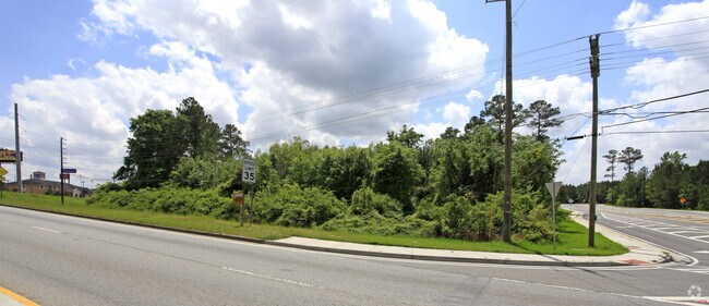
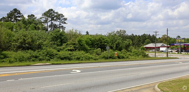
N St Augustine Rd
0081C-005
TRACT 1 LL 15 LD 12 JAMES RD & JAMES CIR LANDLOT: 1 LANDDIST: 12
Commercialacreage
LOWNDES
PMD
Georgia
B and X Area of moderate flood hazard, usually the area between the limits of the 100-year and 500-year floods.
20.04 AC
2025
Valdosta/Lake Park
2025
Other Market Areas
010302
Valdosta, GA
NEARBY LISTINGS FOR SALE OR LEASE
DEMOGRAPHICS near N St Augustine Rd
1 mile
3 mile
5 mile
2025 Total Population
2,261
22,335
62,236
2030 Population
2,301
22,667
63,278
Pop Growth 2025-2030
+ 1.77%
+ 1.49%
+ 1.67%
Average Age
37
36
36
2025 Total Households
958
9,082
24,501
HH Growth 2025-2030
+ 1.77%
+ 1.94%
+ 2.05%
Median Household Inc
$57,894
$45,336
$46,906
Avg Household Size
2.20
2.20
2.30
2025 Avg HH Vehicles
2.00
2.00
2.00
Median Home Value
$239,539
$200,779
$196,657
Median Year Built
1986
1982
1986
Nearby Places
Map Layers
Map Styles
 Street
 Aerial
Layers
 Traffic
 Biking
Places
Listings with unknown addresses are not visible on the map
- Restaurants
- Banks
- Shops
- Fitness
- Groceries
PUBLIC TRANSPORTATION
AIRPORT
Valdosta Regional
Drive
Walk
Distance
Valdosta Regional
13 min
6.9 mi
Freight Ports
Jacksonville Port
Drive
Walk
Distance
Jacksonville Port
142 min
126.1 mi
Nearby Properties
Address
Land Use
TOTAL SIZE
Lot Size
Zoning
Address
Land Use
TOTAL SIZE
Lot Size
Zoning
459,770 SF
30.52 AC
C-H
Address
Land Use
TOTAL SIZE
Lot Size
Zoning
115,460 SF
13.09 AC
R-M
Address
Land Use
TOTAL SIZE
Lot Size
Zoning
104,544 SF
20.31 AC
R-M
Address
Land Use
TOTAL SIZE
Lot Size
Zoning
163,083 SF
17.16 AC
C-H
Address
Land Use
TOTAL SIZE
Lot Size
Zoning
1,686 SF
18.88 AC
R-M
Address
Land Use
TOTAL SIZE
Lot Size
Zoning
203,741 SF
22.55 AC
C-H
Address
Land Use
TOTAL SIZE
Lot Size
Zoning
150,802 SF
11.97 AC
M-1
Address
Land Use
TOTAL SIZE
Lot Size
Zoning
32,886 SF
5.45 AC
C-C
Address
Land Use
TOTAL SIZE
Lot Size
Zoning
104,423 SF
2.62 AC
C-H
Address
Land Use
TOTAL SIZE
Lot Size
Zoning
142,140 SF
24.29 AC
DR-10
Address
Land Use
TOTAL SIZE
Lot Size
Zoning
97,568 SF
3.63 AC
C-H
Address
Land Use
TOTAL SIZE
Lot Size
Zoning
92,322 SF
11.16 AC
C-H
Address
Land Use
TOTAL SIZE
Lot Size
Zoning
101,774 SF
3.55 AC
C-H
Address
Land Use
TOTAL SIZE
Lot Size
Zoning
1,732 SF
9.28 AC
R-M
Address
Land Use
TOTAL SIZE
Lot Size
Zoning
72,557 SF
11.82 AC
C-H
Address
Land Use
TOTAL SIZE
Lot Size
Zoning
101,792 SF
14.09 AC
C-H
Address
Land Use
TOTAL SIZE
Lot Size
Zoning
50,016 SF
3.79 AC
C-C
Address
Land Use
TOTAL SIZE
Lot Size
Zoning
80,062 SF
3 AC
C-H
Address
Land Use
TOTAL SIZE
Lot Size
Zoning
76,250 SF
3.05 AC
C-H
Address
Land Use
TOTAL SIZE
Lot Size
Zoning
120,720 SF
11.31 AC
C-H
Address
Land Use
TOTAL SIZE
Lot Size
Zoning
55,599 SF
2.49 AC
C-H
Address
Land Use
TOTAL SIZE
Lot Size
Zoning
70,358 SF
8.41 AC
R-10
Address
Land Use
TOTAL SIZE
Lot Size
Zoning
56,759 SF
5.74 AC
C-H
Address
Land Use
TOTAL SIZE
Lot Size
Zoning
100,812 SF
6.43 AC
R-M
Address
Land Use
TOTAL SIZE
Lot Size
Zoning
140,398 SF
13.96 AC
C-H
Address
Land Use
TOTAL SIZE
Lot Size
Zoning
48,000 SF
9.06 AC
C-C
Address
Land Use
TOTAL SIZE
Lot Size
Zoning
55,180 SF
2.46 AC
M-2
Address
Land Use
TOTAL SIZE
Lot Size
Zoning
59,044 SF
8.35 AC
C-C
Address
Land Use
TOTAL SIZE
Lot Size
Zoning
83,052 SF
6.81 AC
R-M
Address
Land Use
TOTAL SIZE
Lot Size
Zoning
66,099 SF
3.55 AC
C-H
The World's #1 Commercial Real Estate Marketplace
Connect with us
© 2026 CoStar Group
The information above has been obtained from sources believed reliable. While we do not doubt its accuracy we have not verified it and make no guarantee, warranty or representation about it. It is your responsibility to independently confirm its accuracy and completeness. Any projections, opinions, assumptions, or estimates used are for example only and do not represent the current or future performance of the property. The value of this transaction to you depends on tax and other factors which should be evaluated by your tax, financial, and legal advisors. You and your advisors should conduct a careful, independent investigation of the property to determine to your satisfaction the suitability of the property for your needs.