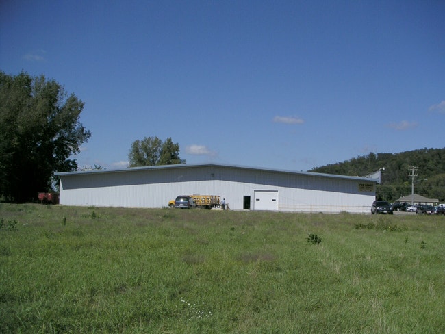
Property Record
N Star Rd, Holmen, WI 54636

NEARBY LISTINGS FOR SALE OR LEASE
Property Detail
N Star Rd
La Crosse-Onalaska, WI-MN
La Crosse County Certified Survey Map
014-000087-025
CERTIFIED SURVEY MAP NO. 151 VOL 4 DOC NO. 1039960 LOT 1 EX PRT TAKEN FOR R/W IN V1172 P389 SUBJ TO ESMT IN V934 P987
Commercialnec
La Crosse
X
Wisconsin
55063C0135D
1
2024
0.71 AC
2024
La Crosse/Onalaska
010204
Other Market Areas
DEMOGRAPHICS near N Star Rd
1 mile
3 mile
5 mile
2024 Total Population
5,445
14,311
22,151
2029 Population
5,454
14,140
22,048
Pop Growth 2024-2029
+ 0.17%
(1.19%)
(0.46%)
Average Age
39
39
40
2024 Total Households
2,104
5,438
8,508
HH Growth 2024-2029
+ 0.05%
(1.25%)
(0.60%)
Median Household Inc
$75,041
$88,921
$89,815
Avg Household Size
2.50
2.60
2.60
2024 Avg HH Vehicles
2.00
2.00
2.00
Median Home Value
$239,655
$252,261
$259,002
Median Year Built
1994
1996
1995
Nearby Places
Map Layers
Map Styles
 Street
 Aerial
Transit
 Traffic
 Biking
Places
Listings with unknown addresses are not visible on the map
- Restaurants
- Banks
- Shops
- Fitness
- Groceries
PUBLIC TRANSPORTATION
AIRPORT
La Crosse Regional
Drive
Walk
Distance
La Crosse Regional
19 min
12.0 mi
SALE & LEASE HISTORY
LISTING DATE
SALE/LEASE

Jul 15, 2021
For Lease
Aug 15, 2017
For Sale
Nearby Properties
Address
Land Use
TOTAL SIZE
Lot Size
Zoning
Address
Land Use
TOTAL SIZE
Lot Size
Zoning
3.06 AC
Address
Land Use
TOTAL SIZE
Lot Size
Zoning
Address
Land Use
TOTAL SIZE
Lot Size
Zoning
Address
Land Use
TOTAL SIZE
Lot Size
Zoning
9.13 AC
Address
Land Use
TOTAL SIZE
Lot Size
Zoning
4.31 AC
Address
Land Use
TOTAL SIZE
Lot Size
Zoning
Address
Land Use
TOTAL SIZE
Lot Size
Zoning
1.98 AC
Address
Land Use
TOTAL SIZE
Lot Size
Zoning
2.16 AC
Address
Land Use
TOTAL SIZE
Lot Size
Zoning
4.60 AC
MZA
Address
Land Use
TOTAL SIZE
Lot Size
Zoning
7.34 AC
MZA
Address
Land Use
TOTAL SIZE
Lot Size
Zoning
5.37 AC
MZA
Address
Land Use
TOTAL SIZE
Lot Size
Zoning
3.50 AC
Address
Land Use
TOTAL SIZE
Lot Size
Zoning
2.82 AC
MZA
Address
Land Use
TOTAL SIZE
Lot Size
Zoning
2.22 AC
Address
Land Use
TOTAL SIZE
Lot Size
Zoning
2.97 AC
Address
Land Use
TOTAL SIZE
Lot Size
Zoning
1.67 AC
MZA
Address
Land Use
TOTAL SIZE
Lot Size
Zoning
3.17 AC
MZA
Address
Land Use
TOTAL SIZE
Lot Size
Zoning
Address
Land Use
TOTAL SIZE
Lot Size
Zoning
1.81 AC
MZA
Address
Land Use
TOTAL SIZE
Lot Size
Zoning
4.89 AC
MZA
Address
Land Use
TOTAL SIZE
Lot Size
Zoning
2.85 AC
MZA
Address
Land Use
TOTAL SIZE
Lot Size
Zoning
1.58 AC
Address
Land Use
TOTAL SIZE
Lot Size
Zoning
1.80 AC
Address
Land Use
TOTAL SIZE
Lot Size
Zoning
0.87 AC
Address
Land Use
TOTAL SIZE
Lot Size
Zoning
1.31 AC
MZA
Address
Land Use
TOTAL SIZE
Lot Size
Zoning
1.31 AC
MZA
Address
Land Use
TOTAL SIZE
Lot Size
Zoning
13.05 AC
Address
Land Use
TOTAL SIZE
Lot Size
Zoning
1.26 AC
Address
Land Use
TOTAL SIZE
Lot Size
Zoning
1.90 AC
MZA
Address
Land Use
TOTAL SIZE
Lot Size
Zoning
0.73 AC
MZA
The World's #1 Commercial Real Estate Marketplace
Connect with us
© 2026 CoStar Group
The information above has been obtained from sources believed reliable. While we do not doubt its accuracy we have not verified it and make no guarantee, warranty or representation about it. It is your responsibility to independently confirm its accuracy and completeness. Any projections, opinions, assumptions, or estimates used are for example only and do not represent the current or future performance of the property. The value of this transaction to you depends on tax and other factors which should be evaluated by your tax, financial, and legal advisors. You and your advisors should conduct a careful, independent investigation of the property to determine to your satisfaction the suitability of the property for your needs.