Property Record
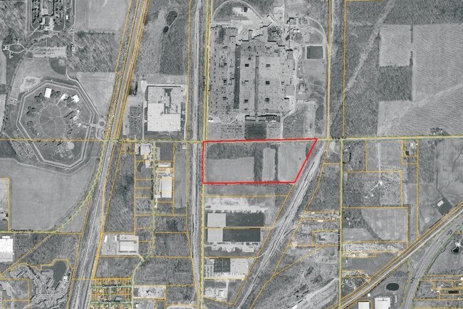
N Sugar St, Lima, OH 45801


Property Detail
N Sugar St
Lima, OH
PT NW1/4 -2.189 CO RD EASE RTS 07-03-20
37-20-00-02-002.000
ALLEN
Industrialacreage
Ohio
B and X Area of moderate flood hazard, usually the area between the limits of the 100-year and 500-year floods.
35.86 AC
2024
Lima/Findlay
2024
Other Market Areas
011200
NEARBY LISTINGS FOR SALE OR LEASE
-
-
View all Lima listings for sale on LoopNet.com
DEMOGRAPHICS near N Sugar St
1 mile
3 mile
5 mile
2025 Total Population
2,247
31,135
58,600
2030 Population
2,241
31,038
58,527
Pop Growth 2025-2030
(0.27%)
(0.31%)
(0.12%)
Average Age
47
39
40
2025 Total Households
307
12,347
23,994
HH Growth 2025-2030
(0.98%)
(0.43%)
(0.22%)
Median Household Inc
$58,695
$49,245
$54,033
Avg Household Size
2.40
2.30
2.30
2025 Avg HH Vehicles
2.00
2.00
2.00
Median Home Value
$129,464
$121,872
$142,979
Median Year Built
1960
1960
1961
Nearby Places
Map Layers
Map Styles
 Street
 Aerial
Transit
 Traffic
 Biking
Places
Listings with unknown addresses are not visible on the map
- Restaurants
- Banks
- Shops
- Fitness
- Groceries
Nearby Properties
Address
Land Use
TOTAL SIZE
Lot Size
Zoning
Address
Land Use
TOTAL SIZE
Lot Size
Zoning
628,932 SF
9.08 AC
Address
Land Use
TOTAL SIZE
Lot Size
Zoning
359,238 SF
9.72 AC
Address
Land Use
TOTAL SIZE
Lot Size
Zoning
242,023 SF
3.81 AC
Address
Land Use
TOTAL SIZE
Lot Size
Zoning
285,016 SF
31.90 AC
Address
Land Use
TOTAL SIZE
Lot Size
Zoning
209,864 SF
87.96 AC
Address
Land Use
TOTAL SIZE
Lot Size
Zoning
523,578 SF
468.55 AC
Address
Land Use
TOTAL SIZE
Lot Size
Zoning
131,584 SF
32.09 AC
Address
Land Use
TOTAL SIZE
Lot Size
Zoning
104,798 SF
0.94 AC
Address
Land Use
TOTAL SIZE
Lot Size
Zoning
120,810 SF
35.76 AC
Address
Land Use
TOTAL SIZE
Lot Size
Zoning
269.47 AC
Address
Land Use
TOTAL SIZE
Lot Size
Zoning
321,048 SF
27.37 AC
Address
Land Use
TOTAL SIZE
Lot Size
Zoning
62,626 SF
5.16 AC
Address
Land Use
TOTAL SIZE
Lot Size
Zoning
96,583 SF
20 AC
Address
Land Use
TOTAL SIZE
Lot Size
Zoning
585,479 SF
28.85 AC
Address
Land Use
TOTAL SIZE
Lot Size
Zoning
50,497 SF
38.72 AC
Address
Land Use
TOTAL SIZE
Lot Size
Zoning
101,362 SF
2.78 AC
Address
Land Use
TOTAL SIZE
Lot Size
Zoning
65,986 SF
6.50 AC
Address
Land Use
TOTAL SIZE
Lot Size
Zoning
87,128 SF
1.89 AC
Address
Land Use
TOTAL SIZE
Lot Size
Zoning
100,154 SF
2.39 AC
Address
Land Use
TOTAL SIZE
Lot Size
Zoning
253,300 SF
1.08 AC
Address
Land Use
TOTAL SIZE
Lot Size
Zoning
98,606 SF
9.42 AC
Address
Land Use
TOTAL SIZE
Lot Size
Zoning
84,488 SF
8.21 AC
Address
Land Use
TOTAL SIZE
Lot Size
Zoning
23,968 SF
18 AC
Address
Land Use
TOTAL SIZE
Lot Size
Zoning
51,217 SF
0.06 AC
Address
Land Use
TOTAL SIZE
Lot Size
Zoning
41,904 SF
0.84 AC
Address
Land Use
TOTAL SIZE
Lot Size
Zoning
64,680 SF
12.88 AC
Address
Land Use
TOTAL SIZE
Lot Size
Zoning
70,054 SF
5 AC
Address
Land Use
TOTAL SIZE
Lot Size
Zoning
94,680 SF
20.01 AC
Address
Land Use
TOTAL SIZE
Lot Size
Zoning
54,306 SF
3.98 AC
Address
Land Use
TOTAL SIZE
Lot Size
Zoning
165,615 SF
20 AC
The World's #1 Commercial Real Estate Marketplace
Connect with us
© 2026 CoStar Group
The information above has been obtained from sources believed reliable. While we do not doubt its accuracy we have not verified it and make no guarantee, warranty or representation about it. It is your responsibility to independently confirm its accuracy and completeness. Any projections, opinions, assumptions, or estimates used are for example only and do not represent the current or future performance of the property. The value of this transaction to you depends on tax and other factors which should be evaluated by your tax, financial, and legal advisors. You and your advisors should conduct a careful, independent investigation of the property to determine to your satisfaction the suitability of the property for your needs.