Property Record
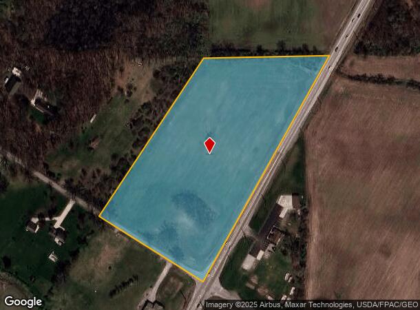
N Telegraph Rd, Monroe, MI 48162
This Property Is For Sale
NEARBY LISTINGS FOR SALE OR LEASE
Property Detail
N Telegraph Rd
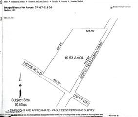
07-017-016-20
PER TWP SEC 17 T6S R9E (PER TWP) 10.48 AMOL COM AT E 1/4 COR SEC 17, TH W'LY ALG EW 1/4 LI SD SEC 761.80 FT FOR POB, SD PT
Residentialacreage
Monroe
X
Michigan
26115C0232E
10.48 AC
2024
Monroe County
2025
Detroit
831500
Monroe, MI
DEMOGRAPHICS near N Telegraph Rd
1 Mile
3 Mile
5 Mile
2024 Total Population
1,262
16,589
53,845
2029 Population
1,294
16,861
54,752
Pop Growth 2024-2029
+ 2.54%
+ 1.64%
+ 1.68%
Average Age
45
42
41
2024 Total Households
489
6,860
21,654
HH Growth 2024-2029
+ 2.66%
+ 1.59%
+ 1.61%
Median Household Inc
$88,529
$61,449
$61,139
Avg Household Size
2.50
2.30
2.40
2024 Avg HH Vehicles
3.00
2.00
2.00
Median Home Value
$289,822
$178,168
$162,831
Median Year Built
1991
1979
1970
Nearby Places
Map Layers
Map Styles
 Street
 Aerial
- Restaurants
- Banks
- Shops
- Fitness
- Groceries
PUBLIC TRANSPORTATION
AIRPORT
Detroit Metro Wayne County
DRIVE
WALK
Distance
Detroit Metro Wayne County
24 min
19.6 mi
Freight Ports
Port of Toledo
DRIVE
WALK
Distance
Port of Toledo
41 min
29.7 mi
Nearby Properties
Address
Land Use
TOTAL SIZE
Lot Size
Zoning
Address
Land Use
TOTAL SIZE
Lot Size
Zoning
200,000 SF
94.63 AC
CO
Address
Land Use
TOTAL SIZE
Lot Size
Zoning
Address
Land Use
TOTAL SIZE
Lot Size
Zoning
409,765 SF
41.46 AC
Address
Land Use
TOTAL SIZE
Lot Size
Zoning
95.60 AC
Address
Land Use
TOTAL SIZE
Lot Size
Zoning
195,744 SF
32.62 AC
C-2-COMMER
Address
Land Use
TOTAL SIZE
Lot Size
Zoning
315,000 SF
24.47 AC
Address
Land Use
TOTAL SIZE
Lot Size
Zoning
3.97 AC
Address
Land Use
TOTAL SIZE
Lot Size
Zoning
5,216 SF
81.10 AC
MHP
Address
Land Use
TOTAL SIZE
Lot Size
Zoning
134,464 SF
34.35 AC
Address
Land Use
TOTAL SIZE
Lot Size
Zoning
192,917 SF
15.81 AC
R3B-MULTIF
Address
Land Use
TOTAL SIZE
Lot Size
Zoning
69,590 SF
11.55 AC
C-2-COMMER
Address
Land Use
TOTAL SIZE
Lot Size
Zoning
291,322 SF
55.05 AC
Address
Land Use
TOTAL SIZE
Lot Size
Zoning
148,343 SF
15.15 AC
Address
Land Use
TOTAL SIZE
Lot Size
Zoning
3,822 SF
16.60 AC
R-1A
Address
Land Use
TOTAL SIZE
Lot Size
Zoning
138,119 SF
15.12 AC
Address
Land Use
TOTAL SIZE
Lot Size
Zoning
189,314 SF
28.56 AC
Address
Land Use
TOTAL SIZE
Lot Size
Zoning
94,324 SF
10.11 AC
Address
Land Use
TOTAL SIZE
Lot Size
Zoning
290,248 SF
52.03 AC
Address
Land Use
TOTAL SIZE
Lot Size
Zoning
142,400 SF
15.20 AC
Address
Land Use
TOTAL SIZE
Lot Size
Zoning
43,127 SF
8.10 AC
Address
Land Use
TOTAL SIZE
Lot Size
Zoning
31.45 AC
Address
Land Use
TOTAL SIZE
Lot Size
Zoning
109,626 SF
8.89 AC
Address
Land Use
TOTAL SIZE
Lot Size
Zoning
2,100 SF
36.48 AC
MHP
Address
Land Use
TOTAL SIZE
Lot Size
Zoning
85,062 SF
9.32 AC
Address
Land Use
TOTAL SIZE
Lot Size
Zoning
19,364 SF
30.80 AC
Address
Land Use
TOTAL SIZE
Lot Size
Zoning
59,326 SF
6.21 AC
Address
Land Use
TOTAL SIZE
Lot Size
Zoning
66,154 SF
6.22 AC
Address
Land Use
TOTAL SIZE
Lot Size
Zoning
40,857 SF
17.30 AC
Address
Land Use
TOTAL SIZE
Lot Size
Zoning
88,848 SF
5.74 AC
Address
Land Use
TOTAL SIZE
Lot Size
Zoning
48,117 SF
8.13 AC
R-1A
The World's #1 Commercial Real Estate Marketplace
Connect with us
© 2025 CoStar Group
The information above has been obtained from sources believed reliable. While we do not doubt its accuracy we have not verified it and make no guarantee, warranty or representation about it. It is your responsibility to independently confirm its accuracy and completeness. Any projections, opinions, assumptions, or estimates used are for example only and do not represent the current or future performance of the property. The value of this transaction to you depends on tax and other factors which should be evaluated by your tax, financial, and legal advisors. You and your advisors should conduct a careful, independent investigation of the property to determine to your satisfaction the suitability of the property for your needs.