Property Record
Us Highway 17 N, Wauchula, FL 33873
NEARBY LISTINGS FOR SALE OR LEASE
Property Detail
Us Highway 17 N
1034-25-0000-02980-0000
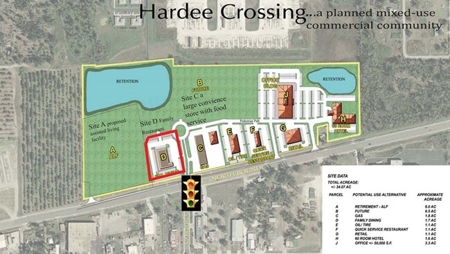
Phase One Subd
Commercialacreage
21.40 AC BEG AT NW COR NE1/4 OF SW1/4 RUN S TO SE COR OF NW1/4 OF SW1/4 THENCE W TO RR R/W THENCE N/LY ALONG RR R/W 250 FT THENCE E 125 FT THENCE N/LY // TO RR R/W 75 FT THENCE W 125 FT ENCE N/LY ALONG RR R/W 1013.63 FT THENCE E ALONG QUARTER SEC LIN
AE
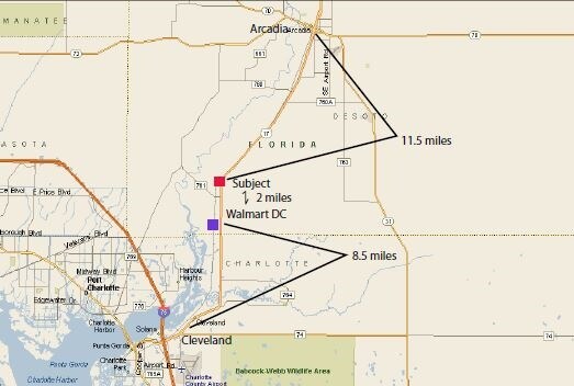
Hardee
12049C0191D
Florida
2025
21.40 AC
2025
Florida Central South Area
970301
Other Market Areas
DEMOGRAPHICS near Us Highway 17 N
1 Mile
3 Mile
5 Mile
2024 Total Population
4,212
9,724
14,765
2029 Population
4,291
9,875
15,018
Pop Growth 2024-2029
+ 1.88%
+ 1.55%
+ 1.71%
Average Age
36
37
37
2024 Total Households
1,382
3,248
4,979
HH Growth 2024-2029
+ 1.95%
+ 1.66%
+ 1.85%
Median Household Inc
$23,192
$34,397
$40,932
Avg Household Size
2.90
2.90
2.90
2024 Avg HH Vehicles
2.00
2.00
2.00
Median Home Value
$87,238
$114,239
$139,509
Median Year Built
1981
1978
1979
Nearby Places
Map Layers
Map Styles
 Street
 Aerial
- Restaurants
- Banks
- Shops
- Fitness
- Groceries
SALE & LEASE HISTORY
LISTING DATE
SALE/LEASE

Sep 24, 2016
For Sale
Nov 07, 2018
For Lease
Nearby Properties
Address
Land Use
TOTAL SIZE
Lot Size
Zoning
Address
Land Use
TOTAL SIZE
Lot Size
Zoning
25 AC
F-R
Address
Land Use
TOTAL SIZE
Lot Size
Zoning
22.21 AC
P-SP
Address
Land Use
TOTAL SIZE
Lot Size
Zoning
47,399 SF
55.51 AC
C-2
Address
Land Use
TOTAL SIZE
Lot Size
Zoning
50,071 SF
9.78 AC
C-2
Address
Land Use
TOTAL SIZE
Lot Size
Zoning
59,117 SF
70 AC
A-1
Address
Land Use
TOTAL SIZE
Lot Size
Zoning
107,610 SF
14.32 AC
C-1
Address
Land Use
TOTAL SIZE
Lot Size
Zoning
45,018 SF
17.48 AC
P-SP
Address
Land Use
TOTAL SIZE
Lot Size
Zoning
40,161 SF
4.48 AC
C-1
Address
Land Use
TOTAL SIZE
Lot Size
Zoning
104,690 SF
9.96 AC
F-R
Address
Land Use
TOTAL SIZE
Lot Size
Zoning
89,500 SF
6.80 AC
C-2
Address
Land Use
TOTAL SIZE
Lot Size
Zoning
54,007 SF
9 AC
P-SP
Address
Land Use
TOTAL SIZE
Lot Size
Zoning
13.28 AC
F-R
Address
Land Use
TOTAL SIZE
Lot Size
Zoning
47,374 SF
1.79 AC
P-SP
Address
Land Use
TOTAL SIZE
Lot Size
Zoning
28.95 AC
P-SP
Address
Land Use
TOTAL SIZE
Lot Size
Zoning
432 SF
9.75 AC
P-SP
Address
Land Use
TOTAL SIZE
Lot Size
Zoning
37,017 SF
100 AC
P-R
Address
Land Use
TOTAL SIZE
Lot Size
Zoning
60,546 SF
14.57 AC
R-3
Address
Land Use
TOTAL SIZE
Lot Size
Zoning
35,140 SF
2.02 AC
P-SP
Address
Land Use
TOTAL SIZE
Lot Size
Zoning
65,778 SF
7.46 AC
F-R
Address
Land Use
TOTAL SIZE
Lot Size
Zoning
330.48 AC
A-1
Address
Land Use
TOTAL SIZE
Lot Size
Zoning
53,214 SF
12.50 AC
R-1A
Address
Land Use
TOTAL SIZE
Lot Size
Zoning
26,155 SF
8.86 AC
A-1
Address
Land Use
TOTAL SIZE
Lot Size
Zoning
80,371 SF
7.52 AC
C-2
Address
Land Use
TOTAL SIZE
Lot Size
Zoning
38,275 SF
18.72 AC
C-2
Address
Land Use
TOTAL SIZE
Lot Size
Zoning
35,537 SF
30 AC
F-R
Address
Land Use
TOTAL SIZE
Lot Size
Zoning
27,168 SF
3.62 AC
C-1
Address
Land Use
TOTAL SIZE
Lot Size
Zoning
29,145 SF
0.80 AC
HC-1
Address
Land Use
TOTAL SIZE
Lot Size
Zoning
97,776 SF
6.29 AC
I
Address
Land Use
TOTAL SIZE
Lot Size
Zoning
40,860 SF
4.63 AC
C-2
Address
Land Use
TOTAL SIZE
Lot Size
Zoning
53,959 SF
16 AC
I-1
The World's #1 Commercial Real Estate Marketplace
Connect with us
© 2026 CoStar Group
The information above has been obtained from sources believed reliable. While we do not doubt its accuracy we have not verified it and make no guarantee, warranty or representation about it. It is your responsibility to independently confirm its accuracy and completeness. Any projections, opinions, assumptions, or estimates used are for example only and do not represent the current or future performance of the property. The value of this transaction to you depends on tax and other factors which should be evaluated by your tax, financial, and legal advisors. You and your advisors should conduct a careful, independent investigation of the property to determine to your satisfaction the suitability of the property for your needs.