Property Record
N Valdosta Rd, , GA
NEARBY LISTINGS FOR SALE OR LEASE
Property Detail
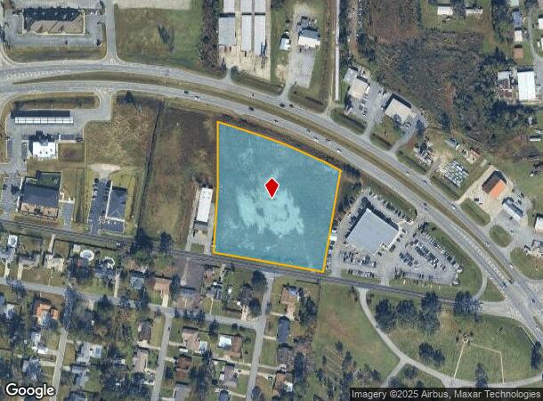
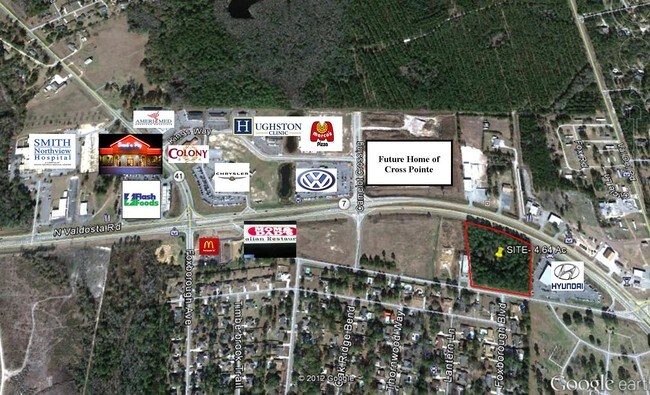
N Valdosta Rd
Valdosta, GA
N Valdosta / I-75
0073-209
LL 11 LD 12
Commercialacreage
Lowndes
X
Georgia
13027C0190D
4.64 AC
2024
Valdosta/Lake Park
2024
Other Market Areas
010302
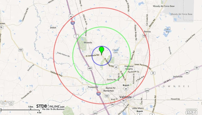
DEMOGRAPHICS near N Valdosta Rd
1 Mile
3 Mile
5 Mile
2024 Total Population
1,923
20,495
66,304
2029 Population
1,981
21,116
68,566
Pop Growth 2024-2029
+ 3.02%
+ 3.03%
+ 3.41%
Average Age
39
38
35
2024 Total Households
748
8,341
25,747
HH Growth 2024-2029
+ 3.07%
+ 3.14%
+ 3.58%
Median Household Inc
$86,050
$70,230
$42,690
Avg Household Size
2.50
2.40
2.40
2024 Avg HH Vehicles
2.00
2.00
2.00
Median Home Value
$189,010
$242,651
$179,417
Median Year Built
1995
1994
1990
Nearby Places
Map Layers
Map Styles
 Street
 Aerial
- Restaurants
- Banks
- Shops
- Fitness
- Groceries
PUBLIC TRANSPORTATION
AIRPORT
Valdosta Regional
DRIVE
WALK
Distance
Valdosta Regional
17 min
9.3 mi
SALE & LEASE HISTORY
LISTING DATE
SALE/LEASE

Jun 07, 2017
For Sale
Nearby Properties
Address
Land Use
TOTAL SIZE
Lot Size
Zoning
Address
Land Use
TOTAL SIZE
Lot Size
Zoning
39,024 SF
18.04 AC
P-D
Address
Land Use
TOTAL SIZE
Lot Size
Zoning
1,728 SF
24.30 AC
R-P, C-C
Address
Land Use
TOTAL SIZE
Lot Size
Zoning
4,878 SF
14.83 AC
R-P
Address
Land Use
TOTAL SIZE
Lot Size
Zoning
19,825 SF
16.93 AC
R-M
Address
Land Use
TOTAL SIZE
Lot Size
Zoning
2,574 SF
12 AC
R-P
Address
Land Use
TOTAL SIZE
Lot Size
Zoning
185,727 SF
20.33 AC
C-H
Address
Land Use
TOTAL SIZE
Lot Size
Zoning
68,592 SF
14.39 AC
C-H
Address
Land Use
TOTAL SIZE
Lot Size
Zoning
114,922 SF
11.38 AC
C-C
Address
Land Use
TOTAL SIZE
Lot Size
Zoning
24,928 SF
10 AC
R-M
Address
Land Use
TOTAL SIZE
Lot Size
Zoning
3,845 SF
14.13 AC
C-H
Address
Land Use
TOTAL SIZE
Lot Size
Zoning
53,880 SF
8.01 AC
C-H,C-C
Address
Land Use
TOTAL SIZE
Lot Size
Zoning
574 SF
7.28 AC
PPD
Address
Land Use
TOTAL SIZE
Lot Size
Zoning
13,056 SF
9.41 AC
R-M
Address
Land Use
TOTAL SIZE
Lot Size
Zoning
1,902 SF
10.58 AC
R-M
Address
Land Use
TOTAL SIZE
Lot Size
Zoning
110,646 SF
9.76 AC
R-P
Address
Land Use
TOTAL SIZE
Lot Size
Zoning
5,247 SF
8.42 AC
R-10
Address
Land Use
TOTAL SIZE
Lot Size
Zoning
45,241 SF
13.16 AC
R-1
Address
Land Use
TOTAL SIZE
Lot Size
Zoning
63,676 SF
3.25 AC
C-H
Address
Land Use
TOTAL SIZE
Lot Size
Zoning
9,180 SF
4.86 AC
C-H
Address
Land Use
TOTAL SIZE
Lot Size
Zoning
8,750 SF
8 AC
C-H
Address
Land Use
TOTAL SIZE
Lot Size
Zoning
1,260 SF
8.21 AC
C-H
Address
Land Use
TOTAL SIZE
Lot Size
Zoning
7,524 SF
6.94 AC
C-G
Address
Land Use
TOTAL SIZE
Lot Size
Zoning
1,624 SF
337.94 AC
R-15
Address
Land Use
TOTAL SIZE
Lot Size
Zoning
0.27 AC
C-C
Address
Land Use
TOTAL SIZE
Lot Size
Zoning
74,989 SF
10.31 AC
P-D
Address
Land Use
TOTAL SIZE
Lot Size
Zoning
60,950 SF
5.81 AC
R-P
Address
Land Use
TOTAL SIZE
Lot Size
Zoning
21,640 SF
6.33 AC
C-H
Address
Land Use
TOTAL SIZE
Lot Size
Zoning
11,815 SF
6.75 AC
C-H
Address
Land Use
TOTAL SIZE
Lot Size
Zoning
4,816 SF
2.82 AC
C-H
Address
Land Use
TOTAL SIZE
Lot Size
Zoning
23,549 SF
4.07 AC
C-H
The World's #1 Commercial Real Estate Marketplace
Connect with us
© 2026 CoStar Group
The information above has been obtained from sources believed reliable. While we do not doubt its accuracy we have not verified it and make no guarantee, warranty or representation about it. It is your responsibility to independently confirm its accuracy and completeness. Any projections, opinions, assumptions, or estimates used are for example only and do not represent the current or future performance of the property. The value of this transaction to you depends on tax and other factors which should be evaluated by your tax, financial, and legal advisors. You and your advisors should conduct a careful, independent investigation of the property to determine to your satisfaction the suitability of the property for your needs.