Property Record
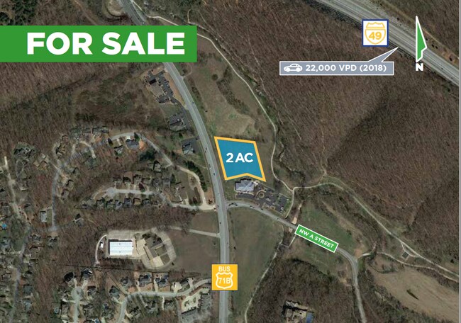
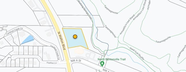
N Walton Blvd, Bentonville, AR

Property Detail
N Walton Blvd
Fayetteville-Springdale-Rogers, AR
P3-791
01-09592-000
BENTON
Commercialacreage
Arkansas
B and X Area of moderate flood hazard, usually the area between the limits of the 100-year and 500-year floods.
1
2025
2 AC
2025
Bentonville
020605
Fayetteville/Springdale/Rogers
NEARBY LISTINGS FOR SALE OR LEASE
DEMOGRAPHICS near N Walton Blvd
1 mile
3 mile
5 mile
2025 Total Population
2,242
23,571
79,350
2030 Population
2,460
26,224
87,797
Pop Growth 2025-2030
+ 9.72%
+ 11.26%
+ 10.65%
Average Age
39
39
37
2025 Total Households
826
9,096
30,740
HH Growth 2025-2030
+ 10.05%
+ 11.64%
+ 10.98%
Median Household Inc
$147,177
$121,718
$107,602
Avg Household Size
2.70
2.50
2.50
2025 Avg HH Vehicles
2.00
2.00
2.00
Median Home Value
$629,154
$525,415
$396,524
Median Year Built
1997
1998
2001
Nearby Places
Map Layers
Map Styles
 Street
 Aerial
Layers
 Traffic
 Biking
Places
Listings with unknown addresses are not visible on the map
- Restaurants
- Banks
- Shops
- Fitness
- Groceries
PUBLIC TRANSPORTATION
AIRPORT
Northwest Arkansas Ntl
Drive
Walk
Distance
Northwest Arkansas Ntl
26 min
14.2 mi
SALE & LEASE HISTORY
LISTING DATE
SALE/LEASE

Nov 12, 2020
For Sale
Nearby Properties
Address
Land Use
TOTAL SIZE
Lot Size
Zoning
Address
Land Use
TOTAL SIZE
Lot Size
Zoning
552,541 SF
26.92 AC
Address
Land Use
TOTAL SIZE
Lot Size
Zoning
149,727 SF
1.32 AC
Address
Land Use
TOTAL SIZE
Lot Size
Zoning
247,292 SF
1.57 AC
Address
Land Use
TOTAL SIZE
Lot Size
Zoning
208,865 SF
7.73 AC
Address
Land Use
TOTAL SIZE
Lot Size
Zoning
39,047 SF
1.43 AC
Address
Land Use
TOTAL SIZE
Lot Size
Zoning
64,098 SF
2.17 AC
Address
Land Use
TOTAL SIZE
Lot Size
Zoning
18,413 SF
0.68 AC
Address
Land Use
TOTAL SIZE
Lot Size
Zoning
118,875 SF
5.06 AC
Address
Land Use
TOTAL SIZE
Lot Size
Zoning
239,145 SF
32.91 AC
Address
Land Use
TOTAL SIZE
Lot Size
Zoning
170,184 SF
10.51 AC
Address
Land Use
TOTAL SIZE
Lot Size
Zoning
148,317 SF
1.74 AC
Address
Land Use
TOTAL SIZE
Lot Size
Zoning
228,855 SF
1.21 AC
Address
Land Use
TOTAL SIZE
Lot Size
Zoning
68,423 SF
1.22 AC
Address
Land Use
TOTAL SIZE
Lot Size
Zoning
71,586 SF
1.24 AC
Address
Land Use
TOTAL SIZE
Lot Size
Zoning
84,697 SF
10.08 AC
Address
Land Use
TOTAL SIZE
Lot Size
Zoning
31,870 SF
9.52 AC
Address
Land Use
TOTAL SIZE
Lot Size
Zoning
104,812 SF
42.30 AC
Address
Land Use
TOTAL SIZE
Lot Size
Zoning
76,684 SF
2.47 AC
Address
Land Use
TOTAL SIZE
Lot Size
Zoning
139,940 SF
15 AC
Address
Land Use
TOTAL SIZE
Lot Size
Zoning
138,513 SF
15.06 AC
Address
Land Use
TOTAL SIZE
Lot Size
Zoning
79,535 SF
9.15 AC
Address
Land Use
TOTAL SIZE
Lot Size
Zoning
45,704 SF
3.55 AC
Address
Land Use
TOTAL SIZE
Lot Size
Zoning
42,483 SF
7.67 AC
Address
Land Use
TOTAL SIZE
Lot Size
Zoning
38,410 SF
0.41 AC
Address
Land Use
TOTAL SIZE
Lot Size
Zoning
42,435 SF
6.95 AC
Address
Land Use
TOTAL SIZE
Lot Size
Zoning
50,643 SF
0.70 AC
Address
Land Use
TOTAL SIZE
Lot Size
Zoning
41,212 SF
2.75 AC
Address
Land Use
TOTAL SIZE
Lot Size
Zoning
26,104 SF
Address
Land Use
TOTAL SIZE
Lot Size
Zoning
25,235 SF
0.51 AC
Address
Land Use
TOTAL SIZE
Lot Size
Zoning
35,536 SF
0.55 AC
The World's #1 Commercial Real Estate Marketplace
Connect with us
© 2026 CoStar Group
The information above has been obtained from sources believed reliable. While we do not doubt its accuracy we have not verified it and make no guarantee, warranty or representation about it. It is your responsibility to independently confirm its accuracy and completeness. Any projections, opinions, assumptions, or estimates used are for example only and do not represent the current or future performance of the property. The value of this transaction to you depends on tax and other factors which should be evaluated by your tax, financial, and legal advisors. You and your advisors should conduct a careful, independent investigation of the property to determine to your satisfaction the suitability of the property for your needs.