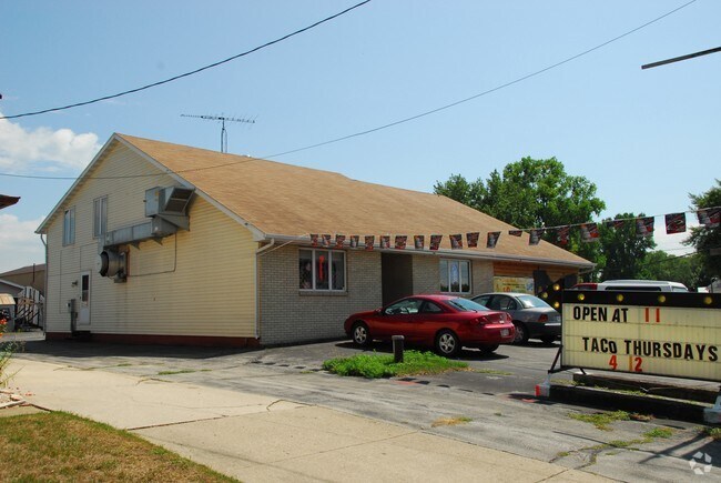
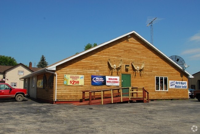
Property Record
N10307 Us Highway 151, Malone, WI 53049

NEARBY LISTINGS FOR SALE OR LEASE
-
-
View all Malone listings for sale on LoopNet.com
Property Detail
N10307 Us Highway 151
T05-17-18-26-03-004-00
S26 T17N R18E PT OF SW 1/4 NE 1/4 & SE 1/4 NW 1/4 COM 176.88' E OF SW COR NE 1/4 TH N67*03'W 221.63' TH N23*12'E 60' TH
Commercialnec
Fond Du Lac
X
Wisconsin
55039C0137F
0.35 AC
2024
Fond du Lac
2024
Milwaukee/Madison
042100
Fond du Lac, WI
DEMOGRAPHICS near N10307 Us Highway 151
1 Mile
3 Mile
5 Mile
2024 Total Population
668
1,215
2,658
2029 Population
669
1,214
2,651
Pop Growth 2024-2029
+ 0.15%
(0.08%)
(0.26%)
Average Age
46
46
46
2024 Total Households
277
502
1,092
HH Growth 2024-2029
0.00%
(0.20%)
(0.37%)
Median Household Inc
$70,908
$72,711
$73,111
Avg Household Size
2.40
2.40
2.40
2024 Avg HH Vehicles
2.00
3.00
3.00
Median Home Value
$259,890
$267,333
$279,038
Median Year Built
1957
1959
1962
Nearby Places
Map Layers
Map Styles
 Street
 Aerial
- Restaurants
- Banks
- Shops
- Fitness
- Groceries
PUBLIC TRANSPORTATION
AIRPORT
Appleton International
DRIVE
WALK
Distance
Appleton International
61 min
36.9 mi
Freight Ports
Port Milwaukee
DRIVE
WALK
Distance
Port Milwaukee
100 min
80.5 mi
Nearby Properties
Address
Land Use
TOTAL SIZE
Lot Size
Zoning
Address
Land Use
TOTAL SIZE
Lot Size
Zoning
14.48 AC
Address
Land Use
TOTAL SIZE
Lot Size
Zoning
35.25 AC
Address
Land Use
TOTAL SIZE
Lot Size
Zoning
Address
Land Use
TOTAL SIZE
Lot Size
Zoning
Address
Land Use
TOTAL SIZE
Lot Size
Zoning
Address
Land Use
TOTAL SIZE
Lot Size
Zoning
12.24 AC
Address
Land Use
TOTAL SIZE
Lot Size
Zoning
Address
Land Use
TOTAL SIZE
Lot Size
Zoning
Address
Land Use
TOTAL SIZE
Lot Size
Zoning
59.95 AC
Address
Land Use
TOTAL SIZE
Lot Size
Zoning
48.16 AC
Address
Land Use
TOTAL SIZE
Lot Size
Zoning
0.54 AC
Address
Land Use
TOTAL SIZE
Lot Size
Zoning
Address
Land Use
TOTAL SIZE
Lot Size
Zoning
Address
Land Use
TOTAL SIZE
Lot Size
Zoning
Address
Land Use
TOTAL SIZE
Lot Size
Zoning
20.40 AC
Address
Land Use
TOTAL SIZE
Lot Size
Zoning
0.52 AC
Address
Land Use
TOTAL SIZE
Lot Size
Zoning
4.18 AC
Address
Land Use
TOTAL SIZE
Lot Size
Zoning
1.33 AC
Address
Land Use
TOTAL SIZE
Lot Size
Zoning
4.48 AC
Address
Land Use
TOTAL SIZE
Lot Size
Zoning
Address
Land Use
TOTAL SIZE
Lot Size
Zoning
Address
Land Use
TOTAL SIZE
Lot Size
Zoning
Address
Land Use
TOTAL SIZE
Lot Size
Zoning
Address
Land Use
TOTAL SIZE
Lot Size
Zoning
41.44 AC
Address
Land Use
TOTAL SIZE
Lot Size
Zoning
6.16 AC
Address
Land Use
TOTAL SIZE
Lot Size
Zoning
Address
Land Use
TOTAL SIZE
Lot Size
Zoning
9.14 AC
Address
Land Use
TOTAL SIZE
Lot Size
Zoning
43.33 AC
Address
Land Use
TOTAL SIZE
Lot Size
Zoning
43.43 AC
The World's #1 Commercial Real Estate Marketplace
Connect with us
© 2026 CoStar Group
The information above has been obtained from sources believed reliable. While we do not doubt its accuracy we have not verified it and make no guarantee, warranty or representation about it. It is your responsibility to independently confirm its accuracy and completeness. Any projections, opinions, assumptions, or estimates used are for example only and do not represent the current or future performance of the property. The value of this transaction to you depends on tax and other factors which should be evaluated by your tax, financial, and legal advisors. You and your advisors should conduct a careful, independent investigation of the property to determine to your satisfaction the suitability of the property for your needs.