Property Record
N15w30921 Golf Rd, Delafield, WI 53018

Property Detail
N15w30921 Golf Rd
Milwaukee-Waukesha, WI
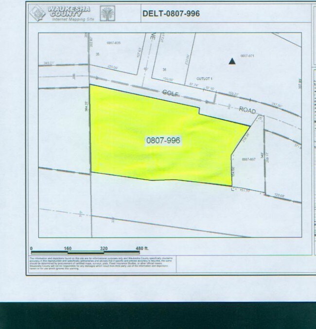
PT NW1/4 SW1/4 SEC 22 T7N R18E COM W1/4 COR S0050E 756.60 FT THE BGN S0050E 418.53 FT S8214E 278.40 FT N8840E 101.27 FT S8214E 253.50 FT N0050W 138.57 FT N3447E 157.49 FT NWLY 29.00 FT ALG CURVE N1245E 60.00 FT N7714W 56.90 FT N7749W 511.93 FT TO BGN
DELT-0807-996
Waukesha
Commercialnec
Wisconsin
B and X Area of moderate flood hazard, usually the area between the limits of the 100-year and 500-year floods.
7
2024
5.13 AC
2024
NE/Delafield
203704
Milwaukee/Madison
NEARBY LISTINGS FOR SALE OR LEASE
DEMOGRAPHICS near N15w30921 Golf Rd
1 mile
3 mile
5 mile
2025 Total Population
1,626
15,029
51,518
2030 Population
1,632
15,258
52,721
Pop Growth 2025-2030
+ 0.37%
+ 1.52%
+ 2.34%
Average Age
46
44
44
2025 Total Households
655
5,912
20,609
HH Growth 2025-2030
+ 0.61%
+ 1.59%
+ 2.35%
Median Household Inc
$154,664
$130,700
$111,810
Avg Household Size
2.50
2.50
2.50
2025 Avg HH Vehicles
2.00
2.00
2.00
Median Home Value
$619,718
$571,016
$468,018
Median Year Built
1988
1987
1989
Nearby Places
Map Layers
Map Styles
 Street
 Aerial
Layers
 Traffic
 Biking
Places
Listings with unknown addresses are not visible on the map
- Restaurants
- Banks
- Shops
- Fitness
- Groceries
PUBLIC TRANSPORTATION
AIRPORT
General Mitchell International
Drive
Walk
Distance
General Mitchell International
43 min
30.6 mi
Freight Ports
Port Milwaukee
Drive
Walk
Distance
Port Milwaukee
36 min
27.2 mi
Nearby Properties
Address
Land Use
TOTAL SIZE
Lot Size
Zoning
Address
Land Use
TOTAL SIZE
Lot Size
Zoning
Address
Land Use
TOTAL SIZE
Lot Size
Zoning
7.45 AC
Address
Land Use
TOTAL SIZE
Lot Size
Zoning
1.05 AC
Address
Land Use
TOTAL SIZE
Lot Size
Zoning
14.91 AC
Address
Land Use
TOTAL SIZE
Lot Size
Zoning
16.23 AC
Address
Land Use
TOTAL SIZE
Lot Size
Zoning
8.48 AC
Address
Land Use
TOTAL SIZE
Lot Size
Zoning
6.66 AC
Address
Land Use
TOTAL SIZE
Lot Size
Zoning
6.33 AC
Address
Land Use
TOTAL SIZE
Lot Size
Zoning
7.04 AC
Address
Land Use
TOTAL SIZE
Lot Size
Zoning
Address
Land Use
TOTAL SIZE
Lot Size
Zoning
Address
Land Use
TOTAL SIZE
Lot Size
Zoning
1.71 AC
Address
Land Use
TOTAL SIZE
Lot Size
Zoning
Address
Land Use
TOTAL SIZE
Lot Size
Zoning
28.53 AC
Address
Land Use
TOTAL SIZE
Lot Size
Zoning
10.89 AC
Address
Land Use
TOTAL SIZE
Lot Size
Zoning
12.11 AC
Address
Land Use
TOTAL SIZE
Lot Size
Zoning
2.83 AC
Address
Land Use
TOTAL SIZE
Lot Size
Zoning
18.15 AC
Address
Land Use
TOTAL SIZE
Lot Size
Zoning
3.74 AC
Address
Land Use
TOTAL SIZE
Lot Size
Zoning
2.86 AC
Address
Land Use
TOTAL SIZE
Lot Size
Zoning
11.21 AC
Address
Land Use
TOTAL SIZE
Lot Size
Zoning
Address
Land Use
TOTAL SIZE
Lot Size
Zoning
Address
Land Use
TOTAL SIZE
Lot Size
Zoning
12.98 AC
Address
Land Use
TOTAL SIZE
Lot Size
Zoning
5.31 AC
B-6
Address
Land Use
TOTAL SIZE
Lot Size
Zoning
7.10 AC
Address
Land Use
TOTAL SIZE
Lot Size
Zoning
Address
Land Use
TOTAL SIZE
Lot Size
Zoning
Address
Land Use
TOTAL SIZE
Lot Size
Zoning
Address
Land Use
TOTAL SIZE
Lot Size
Zoning
6.83 AC
The World's #1 Commercial Real Estate Marketplace
Connect with us
© 2026 CoStar Group
The information above has been obtained from sources believed reliable. While we do not doubt its accuracy we have not verified it and make no guarantee, warranty or representation about it. It is your responsibility to independently confirm its accuracy and completeness. Any projections, opinions, assumptions, or estimates used are for example only and do not represent the current or future performance of the property. The value of this transaction to you depends on tax and other factors which should be evaluated by your tax, financial, and legal advisors. You and your advisors should conduct a careful, independent investigation of the property to determine to your satisfaction the suitability of the property for your needs.