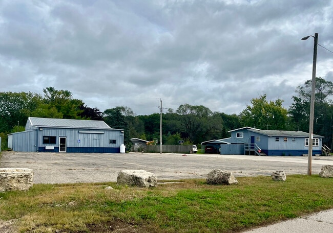
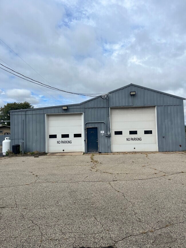
Property Record
N5106 State Road 35, Onalaska, WI 54650

Property Detail
N5106 State Road 35
010001142001
PRT SE-NW COM NW COR E 150FT S 615FT W 16FT S13D49ME 61FT N88D1ME 445.6FT S1D47ME 536FT S80D13MW 120.56FT TO POB S80D13MW 129.44FT N15DW 17.6FT S80DW 78FT N13D49MW 258.5FT N88D1ME 214.55FT S1D47ME 25FT N88D1ME 10.46FT S11D1ME 225.18FT TO POB SUBJ TO
Commercialnec
LA CROSSE
COMMERCIAL
Wisconsin
B and X Area of moderate flood hazard, usually the area between the limits of the 100-year and 500-year floods.
1.22 AC
2025
La Crosse/Onalaska
2025
Other Market Areas
010404
La Crosse-Onalaska, WI-MN
NEARBY LISTINGS FOR SALE OR LEASE
-
-
View all Onalaska listings for lease on LoopNet.com
DEMOGRAPHICS near N5106 State Road 35
1 mile
3 mile
5 mile
2025 Total Population
6,209
24,489
48,153
2030 Population
6,401
24,718
48,273
Pop Growth 2025-2030
+ 3.09%
+ 0.94%
+ 0.25%
Average Age
41
42
41
2025 Total Households
2,573
10,066
19,921
HH Growth 2025-2030
+ 2.91%
+ 0.69%
(0.01%)
Median Household Inc
$91,515
$83,171
$74,786
Avg Household Size
2.40
2.40
2.40
2025 Avg HH Vehicles
2.00
2.00
2.00
Median Home Value
$327,222
$309,407
$289,900
Median Year Built
1995
1990
1984
Nearby Places
Map Layers
Map Styles
 Street
 Aerial
Layers
 Traffic
 Biking
Places
Listings with unknown addresses are not visible on the map
- Restaurants
- Banks
- Shops
- Fitness
- Groceries
PUBLIC TRANSPORTATION
COMMUTER RAIL
La Crosse (Empire Builder - Amtrak)
Drive
Walk
Distance
La Crosse (Empire Builder - Amtrak)
15 min
5.8 mi
AIRPORT
La Crosse Regional
Drive
Walk
Distance
La Crosse Regional
14 min
5.8 mi
Freight Ports
Port Milwaukee
Drive
Walk
Distance
Port Milwaukee
235 min
210.3 mi
SALE & LEASE HISTORY
LISTING DATE
SALE/LEASE

Oct 15, 2025
For Lease
Oct 09, 2025
For Lease
Nearby Properties
Address
Land Use
TOTAL SIZE
Lot Size
Zoning
Address
Land Use
TOTAL SIZE
Lot Size
Zoning
7.68 AC
MZA
Address
Land Use
TOTAL SIZE
Lot Size
Zoning
29.80 AC
MZA
Address
Land Use
TOTAL SIZE
Lot Size
Zoning
14.59 AC
MZA
Address
Land Use
TOTAL SIZE
Lot Size
Zoning
2.52 AC
Address
Land Use
TOTAL SIZE
Lot Size
Zoning
15.41 AC
MZA
Address
Land Use
TOTAL SIZE
Lot Size
Zoning
4.40 AC
Address
Land Use
TOTAL SIZE
Lot Size
Zoning
19.98 AC
Address
Land Use
TOTAL SIZE
Lot Size
Zoning
3.75 AC
Address
Land Use
TOTAL SIZE
Lot Size
Zoning
4.31 AC
Address
Land Use
TOTAL SIZE
Lot Size
Zoning
6.19 AC
Address
Land Use
TOTAL SIZE
Lot Size
Zoning
1.96 AC
Address
Land Use
TOTAL SIZE
Lot Size
Zoning
11.04 AC
MZA
Address
Land Use
TOTAL SIZE
Lot Size
Zoning
9.25 AC
Address
Land Use
TOTAL SIZE
Lot Size
Zoning
12.61 AC
Address
Land Use
TOTAL SIZE
Lot Size
Zoning
Address
Land Use
TOTAL SIZE
Lot Size
Zoning
3.72 AC
MZA
Address
Land Use
TOTAL SIZE
Lot Size
Zoning
2.27 AC
Address
Land Use
TOTAL SIZE
Lot Size
Zoning
5.73 AC
Address
Land Use
TOTAL SIZE
Lot Size
Zoning
24.16 AC
COND USE
Address
Land Use
TOTAL SIZE
Lot Size
Zoning
1.98 AC
Address
Land Use
TOTAL SIZE
Lot Size
Zoning
2.07 AC
Address
Land Use
TOTAL SIZE
Lot Size
Zoning
1.98 AC
MZA
Address
Land Use
TOTAL SIZE
Lot Size
Zoning
2.16 AC
Address
Land Use
TOTAL SIZE
Lot Size
Zoning
2.76 AC
Address
Land Use
TOTAL SIZE
Lot Size
Zoning
20.59 AC
MZA
Address
Land Use
TOTAL SIZE
Lot Size
Zoning
6.03 AC
MZA
Address
Land Use
TOTAL SIZE
Lot Size
Zoning
5.97 AC
MZA
Address
Land Use
TOTAL SIZE
Lot Size
Zoning
2.30 AC
MZA
Address
Land Use
TOTAL SIZE
Lot Size
Zoning
2.41 AC
MZA
Address
Land Use
TOTAL SIZE
Lot Size
Zoning
3.85 AC
MZA
The World's #1 Commercial Real Estate Marketplace
Connect with us
© 2026 CoStar Group
The information above has been obtained from sources believed reliable. While we do not doubt its accuracy we have not verified it and make no guarantee, warranty or representation about it. It is your responsibility to independently confirm its accuracy and completeness. Any projections, opinions, assumptions, or estimates used are for example only and do not represent the current or future performance of the property. The value of this transaction to you depends on tax and other factors which should be evaluated by your tax, financial, and legal advisors. You and your advisors should conduct a careful, independent investigation of the property to determine to your satisfaction the suitability of the property for your needs.