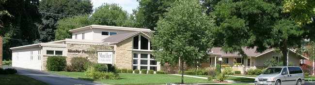
Property Record
N527-31 Hanover Ave, Cedarburg, WI 53012
NEARBY LISTINGS FOR SALE OR LEASE
Property Detail
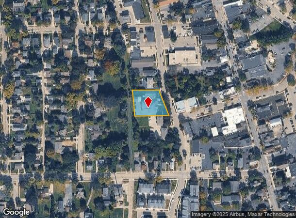
N527-31 Hanover Ave
Milwaukee-Waukesha-West Allis, WI
Assessors Plat
130500910002
711/268 635/348 PART LOT 10 BLK 9 S 148.38 FT LY W OF 2ND AVE ASSESSOR'S PLAT
Commercialnec
Ozaukee
X
Wisconsin
55089C0186G
10
2024
0.61 AC
2024
North Ozaukee
650102
Milwaukee/Madison
DEMOGRAPHICS near N527-31 Hanover Ave
1 Mile
3 Mile
5 Mile
2024 Total Population
5,158
25,441
46,890
2029 Population
5,181
26,059
48,597
Pop Growth 2024-2029
+ 0.45%
+ 2.43%
+ 3.64%
Average Age
42
43
43
2024 Total Households
2,143
10,475
18,859
HH Growth 2024-2029
+ 0.05%
+ 2.30%
+ 3.57%
Median Household Inc
$79,881
$81,994
$94,626
Avg Household Size
2.30
2.30
2.40
2024 Avg HH Vehicles
2.00
2.00
2.00
Median Home Value
$367,883
$326,876
$349,810
Median Year Built
1974
1975
1977
Nearby Places
Map Layers
Map Styles
 Street
 Aerial
- Restaurants
- Banks
- Shops
- Fitness
- Groceries
PUBLIC TRANSPORTATION
AIRPORT
General Mitchell International
DRIVE
WALK
Distance
General Mitchell International
45 min
28.3 mi
Nearby Properties
Address
Land Use
TOTAL SIZE
Lot Size
Zoning
Address
Land Use
TOTAL SIZE
Lot Size
Zoning
Address
Land Use
TOTAL SIZE
Lot Size
Zoning
14.07 AC
Address
Land Use
TOTAL SIZE
Lot Size
Zoning
Address
Land Use
TOTAL SIZE
Lot Size
Zoning
Address
Land Use
TOTAL SIZE
Lot Size
Zoning
Address
Land Use
TOTAL SIZE
Lot Size
Zoning
Address
Land Use
TOTAL SIZE
Lot Size
Zoning
13.19 AC
Address
Land Use
TOTAL SIZE
Lot Size
Zoning
7.64 AC
Address
Land Use
TOTAL SIZE
Lot Size
Zoning
Address
Land Use
TOTAL SIZE
Lot Size
Zoning
Address
Land Use
TOTAL SIZE
Lot Size
Zoning
27.88 AC
Address
Land Use
TOTAL SIZE
Lot Size
Zoning
Address
Land Use
TOTAL SIZE
Lot Size
Zoning
Address
Land Use
TOTAL SIZE
Lot Size
Zoning
9.30 AC
Address
Land Use
TOTAL SIZE
Lot Size
Zoning
Address
Land Use
TOTAL SIZE
Lot Size
Zoning
9.83 AC
Address
Land Use
TOTAL SIZE
Lot Size
Zoning
2.03 AC
Address
Land Use
TOTAL SIZE
Lot Size
Zoning
Address
Land Use
TOTAL SIZE
Lot Size
Zoning
Address
Land Use
TOTAL SIZE
Lot Size
Zoning
Address
Land Use
TOTAL SIZE
Lot Size
Zoning
Address
Land Use
TOTAL SIZE
Lot Size
Zoning
0.92 AC
Address
Land Use
TOTAL SIZE
Lot Size
Zoning
6.07 AC
Address
Land Use
TOTAL SIZE
Lot Size
Zoning
Address
Land Use
TOTAL SIZE
Lot Size
Zoning
Address
Land Use
TOTAL SIZE
Lot Size
Zoning
44.48 AC
Address
Land Use
TOTAL SIZE
Lot Size
Zoning
Address
Land Use
TOTAL SIZE
Lot Size
Zoning
Address
Land Use
TOTAL SIZE
Lot Size
Zoning
Address
Land Use
TOTAL SIZE
Lot Size
Zoning
7.82 AC
The World's #1 Commercial Real Estate Marketplace
Connect with us
© 2025 CoStar Group
The information above has been obtained from sources believed reliable. While we do not doubt its accuracy we have not verified it and make no guarantee, warranty or representation about it. It is your responsibility to independently confirm its accuracy and completeness. Any projections, opinions, assumptions, or estimates used are for example only and do not represent the current or future performance of the property. The value of this transaction to you depends on tax and other factors which should be evaluated by your tax, financial, and legal advisors. You and your advisors should conduct a careful, independent investigation of the property to determine to your satisfaction the suitability of the property for your needs.