Property Record
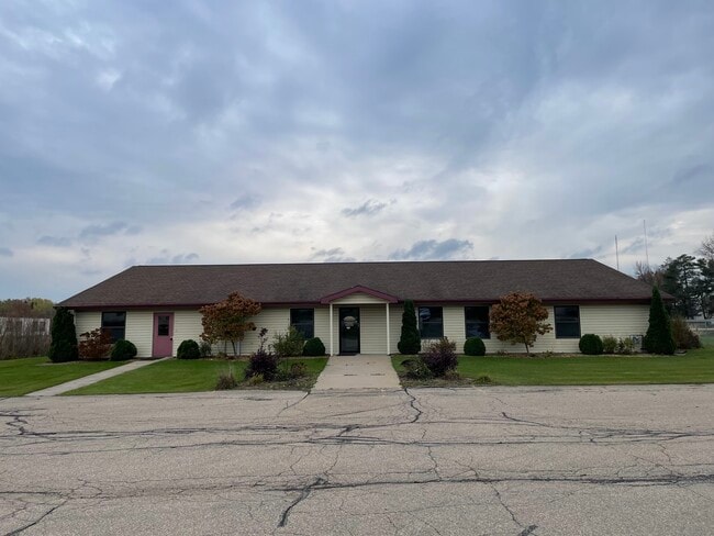
N5364 Poplar Rd, Shawano, WI 54166

Property Detail
N5364 Poplar Rd
Shawano, WI
PRT SW 1/4 SW 1/4 SEC 25 T27N R15E WAS LOT 1 AND OUTLOT 1 V5 CSM P495 MAP #1578 NKA LOT 2 CSM MAP #4733
040-25-3-30-0021
Shawano
Taxexempt
Wisconsin
B and X Area of moderate flood hazard, usually the area between the limits of the 100-year and 500-year floods.
1-2
0
1.32 AC
2025
Wisconsin North Area
100300
Other Market Areas
NEARBY LISTINGS FOR SALE OR LEASE
DEMOGRAPHICS near N5364 Poplar Rd
1 mile
3 mile
5 mile
2025 Total Population
2,474
11,343
14,825
2030 Population
2,534
11,626
15,270
Pop Growth 2025-2030
+ 2.43%
+ 2.49%
+ 3.00%
Average Age
41
42
43
2025 Total Households
1,048
4,882
6,472
HH Growth 2025-2030
+ 2.10%
+ 2.40%
+ 2.97%
Median Household Inc
$66,544
$58,793
$60,973
Avg Household Size
2.30
2.20
2.20
2025 Avg HH Vehicles
2.00
2.00
2.00
Median Home Value
$175,694
$168,623
$178,923
Median Year Built
1963
1972
1975
Nearby Places
Map Layers
Map Styles
 Street
 Aerial
Layers
 Traffic
 Biking
Places
Listings with unknown addresses are not visible on the map
- Restaurants
- Banks
- Shops
- Fitness
- Groceries
SALE & LEASE HISTORY
LISTING DATE
SALE/LEASE

Mar 09, 2022
For Sale
Dec 02, 2021
For Sale
Nearby Properties
Address
Land Use
TOTAL SIZE
Lot Size
Zoning
Address
Land Use
TOTAL SIZE
Lot Size
Zoning
18.66 AC
Address
Land Use
TOTAL SIZE
Lot Size
Zoning
80,756 SF
13.98 AC
Address
Land Use
TOTAL SIZE
Lot Size
Zoning
18.06 AC
Address
Land Use
TOTAL SIZE
Lot Size
Zoning
194,279 SF
23.10 AC
Address
Land Use
TOTAL SIZE
Lot Size
Zoning
24,904 SF
3.84 AC
Address
Land Use
TOTAL SIZE
Lot Size
Zoning
16,512 SF
10.84 AC
Address
Land Use
TOTAL SIZE
Lot Size
Zoning
13.40 AC
Address
Land Use
TOTAL SIZE
Lot Size
Zoning
48,235 SF
4.19 AC
Address
Land Use
TOTAL SIZE
Lot Size
Zoning
20.09 AC
Address
Land Use
TOTAL SIZE
Lot Size
Zoning
44,636 SF
3.06 AC
Address
Land Use
TOTAL SIZE
Lot Size
Zoning
14.93 AC
Address
Land Use
TOTAL SIZE
Lot Size
Zoning
14.37 AC
Address
Land Use
TOTAL SIZE
Lot Size
Zoning
18.51 AC
Address
Land Use
TOTAL SIZE
Lot Size
Zoning
13,328 SF
5.03 AC
Address
Land Use
TOTAL SIZE
Lot Size
Zoning
8.25 AC
Address
Land Use
TOTAL SIZE
Lot Size
Zoning
35,169 SF
8.77 AC
Address
Land Use
TOTAL SIZE
Lot Size
Zoning
1,416 SF
5.39 AC
Address
Land Use
TOTAL SIZE
Lot Size
Zoning
32,124 SF
5.86 AC
Address
Land Use
TOTAL SIZE
Lot Size
Zoning
9.29 AC
Address
Land Use
TOTAL SIZE
Lot Size
Zoning
42,000 SF
6.38 AC
Address
Land Use
TOTAL SIZE
Lot Size
Zoning
7,898 SF
12.02 AC
Address
Land Use
TOTAL SIZE
Lot Size
Zoning
7.91 AC
Address
Land Use
TOTAL SIZE
Lot Size
Zoning
5.87 AC
Address
Land Use
TOTAL SIZE
Lot Size
Zoning
7.60 AC
Address
Land Use
TOTAL SIZE
Lot Size
Zoning
38,524 SF
4.47 AC
Address
Land Use
TOTAL SIZE
Lot Size
Zoning
4.98 AC
Address
Land Use
TOTAL SIZE
Lot Size
Zoning
7,568 SF
4.75 AC
Address
Land Use
TOTAL SIZE
Lot Size
Zoning
4,680 SF
0.71 AC
Address
Land Use
TOTAL SIZE
Lot Size
Zoning
34,360 SF
3.05 AC
Address
Land Use
TOTAL SIZE
Lot Size
Zoning
The World's #1 Commercial Real Estate Marketplace
Connect with us
© 2026 CoStar Group
The information above has been obtained from sources believed reliable. While we do not doubt its accuracy we have not verified it and make no guarantee, warranty or representation about it. It is your responsibility to independently confirm its accuracy and completeness. Any projections, opinions, assumptions, or estimates used are for example only and do not represent the current or future performance of the property. The value of this transaction to you depends on tax and other factors which should be evaluated by your tax, financial, and legal advisors. You and your advisors should conduct a careful, independent investigation of the property to determine to your satisfaction the suitability of the property for your needs.