Property Record
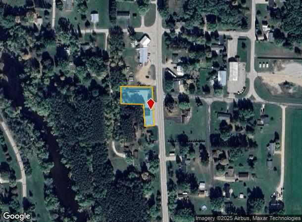
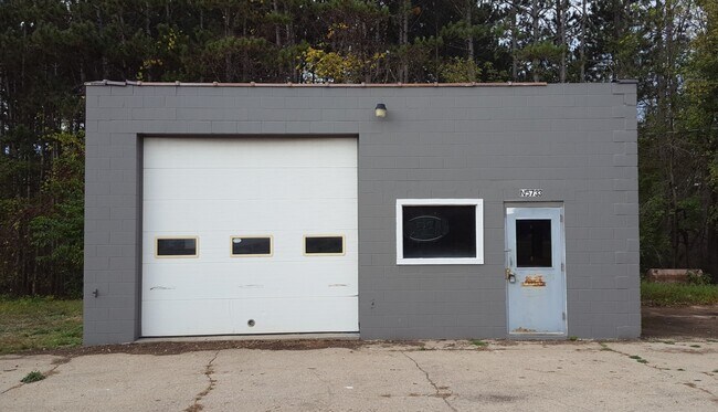
N5733 State Road 22 110, Manawa, WI 54949

NEARBY LISTINGS FOR SALE OR LEASE
-
-
View all Manawa listings for sale on LoopNet.com
Property Detail
N5733 State Road 22 110
13-21-43-37
SEC21 T23N R13E PRT SWSE DESC V657P172 & V765P158 & S60FT LTS6,7&8 BLK14 ORIG PL LY W HWYDESC V948P72 INCLUDES #857131 EX #857123 V587P179 V653P344&346 V657P172 V765P158 V948P72 .56A M/L
Commercialnec
Waupaca
X
Wisconsin
55135C0358D
6,7,8
2023
0.56 AC
2024
Wisconsin North Area
100400
Other Market Areas
480 SF
DEMOGRAPHICS near N5733 State Road 22 110
1 Mile
3 Mile
5 Mile
2024 Total Population
670
3,059
3,305
2029 Population
672
3,070
3,313
Pop Growth 2024-2029
+ 0.30%
+ 0.36%
+ 0.24%
Average Age
41
42
42
2024 Total Households
275
1,246
1,346
HH Growth 2024-2029
+ 0.36%
+ 0.24%
+ 0.15%
Median Household Inc
$73,827
$74,019
$73,779
Avg Household Size
2.40
2.40
2.40
2024 Avg HH Vehicles
2.00
2.00
2.00
Median Home Value
$160,988
$175,789
$177,994
Median Year Built
1973
1975
1975
Nearby Places
Map Layers
Map Styles
 Street
 Aerial
- Restaurants
- Banks
- Shops
- Fitness
- Groceries
PUBLIC TRANSPORTATION
AIRPORT
Appleton International
DRIVE
WALK
Distance
Appleton International
51 min
31.5 mi
Freight Ports
Port Milwaukee
DRIVE
WALK
Distance
Port Milwaukee
157 min
131.1 mi
SALE & LEASE HISTORY
LISTING DATE
SALE/LEASE

Mar 26, 2021
For Sale
Nearby Properties
Address
Land Use
TOTAL SIZE
Lot Size
Zoning
Address
Land Use
TOTAL SIZE
Lot Size
Zoning
55.86 AC
Address
Land Use
TOTAL SIZE
Lot Size
Zoning
10.02 AC
Address
Land Use
TOTAL SIZE
Lot Size
Zoning
53,760 SF
8.27 AC
Address
Land Use
TOTAL SIZE
Lot Size
Zoning
13,016 SF
2.40 AC
Address
Land Use
TOTAL SIZE
Lot Size
Zoning
9.04 AC
Address
Land Use
TOTAL SIZE
Lot Size
Zoning
25.63 AC
O-P
Address
Land Use
TOTAL SIZE
Lot Size
Zoning
3,136 SF
69 AC
A-G
Address
Land Use
TOTAL SIZE
Lot Size
Zoning
4,608 SF
40 AC
A-G
Address
Land Use
TOTAL SIZE
Lot Size
Zoning
4,188 SF
40 AC
A-G
Address
Land Use
TOTAL SIZE
Lot Size
Zoning
22,797 SF
1.10 AC
Address
Land Use
TOTAL SIZE
Lot Size
Zoning
30.52 AC
A-G
Address
Land Use
TOTAL SIZE
Lot Size
Zoning
4,784 SF
37.86 AC
Address
Land Use
TOTAL SIZE
Lot Size
Zoning
4,600 SF
43.10 AC
A-G
Address
Land Use
TOTAL SIZE
Lot Size
Zoning
13.98 AC
Address
Land Use
TOTAL SIZE
Lot Size
Zoning
5,256 SF
42.90 AC
A-G
Address
Land Use
TOTAL SIZE
Lot Size
Zoning
3,904 SF
41 AC
A-G
Address
Land Use
TOTAL SIZE
Lot Size
Zoning
6,032 SF
10.50 AC
AG
Address
Land Use
TOTAL SIZE
Lot Size
Zoning
980 SF
45.25 AC
A-G
Address
Land Use
TOTAL SIZE
Lot Size
Zoning
Address
Land Use
TOTAL SIZE
Lot Size
Zoning
0.99 AC
Address
Land Use
TOTAL SIZE
Lot Size
Zoning
4,779 SF
40 AC
AG
Address
Land Use
TOTAL SIZE
Lot Size
Zoning
5,046 SF
11 AC
A-G
Address
Land Use
TOTAL SIZE
Lot Size
Zoning
3,728 SF
11 AC
A-G
Address
Land Use
TOTAL SIZE
Lot Size
Zoning
22.50 AC
A-G
Address
Land Use
TOTAL SIZE
Lot Size
Zoning
784 SF
19.16 AC
O-N
Address
Land Use
TOTAL SIZE
Lot Size
Zoning
17.69 AC
A-G
Address
Land Use
TOTAL SIZE
Lot Size
Zoning
3,684 SF
36.31 AC
A-G
Address
Land Use
TOTAL SIZE
Lot Size
Zoning
3,072 SF
32.61 AC
A-G
Address
Land Use
TOTAL SIZE
Lot Size
Zoning
11,662 SF
1 AC
Address
Land Use
TOTAL SIZE
Lot Size
Zoning
3,860 SF
15.23 AC
A-G
The World's #1 Commercial Real Estate Marketplace
Connect with us
© 2025 CoStar Group
The information above has been obtained from sources believed reliable. While we do not doubt its accuracy we have not verified it and make no guarantee, warranty or representation about it. It is your responsibility to independently confirm its accuracy and completeness. Any projections, opinions, assumptions, or estimates used are for example only and do not represent the current or future performance of the property. The value of this transaction to you depends on tax and other factors which should be evaluated by your tax, financial, and legal advisors. You and your advisors should conduct a careful, independent investigation of the property to determine to your satisfaction the suitability of the property for your needs.