Property Record
N8353 State Highway 13, Phillips, WI 54555
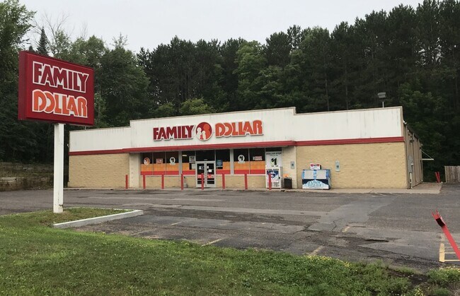

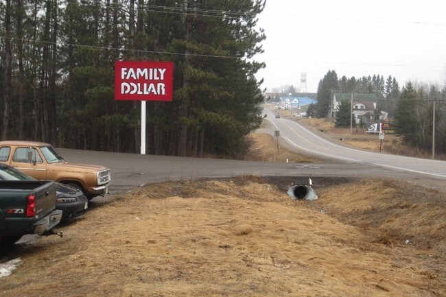
Property Detail
N8353 State Highway 13
50-034-4-37-01-19-1 04-000-10000
19-37-1E PRT OF N 1/2 SE-NE DESC IN 397253
Taxexempt
Price
COMMERCIAL
Wisconsin
0
1 AC
2025
Wisconsin North Area
970600
Other Market Areas
NEARBY LISTINGS FOR SALE OR LEASE
-
-
View all Phillips listings for lease on LoopNet.com
DEMOGRAPHICS near N8353 State Highway 13
1 mile
3 mile
5 mile
2025 Total Population
747
2,435
3,217
2030 Population
746
2,441
3,224
Pop Growth 2025-2030
(0.13%)
+ 0.25%
+ 0.22%
Average Age
43
46
47
2025 Total Households
313
1,104
1,478
HH Growth 2025-2030
0.00%
+ 0.36%
+ 0.34%
Median Household Inc
$56,176
$56,652
$57,232
Avg Household Size
2.10
2.10
2.10
2025 Avg HH Vehicles
2.00
2.00
2.00
Median Home Value
$108,654
$174,390
$178,333
Median Year Built
1959
1974
1975
Nearby Places
Map Layers
Map Styles
 Street
 Aerial
Layers
 Traffic
 Biking
Places
Listings with unknown addresses are not visible on the map
- Restaurants
- Banks
- Shops
- Fitness
- Groceries
SALE & LEASE HISTORY
LISTING DATE
SALE/LEASE

Sep 16, 2021
For Sale
Sep 16, 2021
For Lease
Nov 12, 2021
For Lease
Nov 11, 2021
For Sale
May 16, 2017
For Sale
Nearby Properties
Address
Land Use
TOTAL SIZE
Lot Size
Zoning
Address
Land Use
TOTAL SIZE
Lot Size
Zoning
8.24 AC
I1
Address
Land Use
TOTAL SIZE
Lot Size
Zoning
6.97 AC
I1
Address
Land Use
TOTAL SIZE
Lot Size
Zoning
2.17 AC
I1
Address
Land Use
TOTAL SIZE
Lot Size
Zoning
40 AC
AGRICULTUR
Address
Land Use
TOTAL SIZE
Lot Size
Zoning
173.84 AC
I1
Address
Land Use
TOTAL SIZE
Lot Size
Zoning
5.06 AC
Address
Land Use
TOTAL SIZE
Lot Size
Zoning
11.33 AC
I1
Address
Land Use
TOTAL SIZE
Lot Size
Zoning
1.80 AC
I1
Address
Land Use
TOTAL SIZE
Lot Size
Zoning
11.29 AC
I1
Address
Land Use
TOTAL SIZE
Lot Size
Zoning
2.34 AC
C1
Address
Land Use
TOTAL SIZE
Lot Size
Zoning
3.49 AC
AGRICULTUR
Address
Land Use
TOTAL SIZE
Lot Size
Zoning
0.17 AC
C1
Address
Land Use
TOTAL SIZE
Lot Size
Zoning
4.14 AC
I1
Address
Land Use
TOTAL SIZE
Lot Size
Zoning
8.58 AC
RECREATION
Address
Land Use
TOTAL SIZE
Lot Size
Zoning
1.30 AC
C1
Address
Land Use
TOTAL SIZE
Lot Size
Zoning
11.50 AC
RECREATION
Address
Land Use
TOTAL SIZE
Lot Size
Zoning
Address
Land Use
TOTAL SIZE
Lot Size
Zoning
1.98 AC
REC BUSINE
Address
Land Use
TOTAL SIZE
Lot Size
Zoning
2.37 AC
R1
Address
Land Use
TOTAL SIZE
Lot Size
Zoning
0.86 AC
R2
Address
Land Use
TOTAL SIZE
Lot Size
Zoning
2.71 AC
C1
Address
Land Use
TOTAL SIZE
Lot Size
Zoning
3.26 AC
C1
Address
Land Use
TOTAL SIZE
Lot Size
Zoning
1.13 AC
RECREATION
Address
Land Use
TOTAL SIZE
Lot Size
Zoning
0.17 AC
C1
Address
Land Use
TOTAL SIZE
Lot Size
Zoning
1.56 AC
C1
Address
Land Use
TOTAL SIZE
Lot Size
Zoning
4 AC
RECREATION
Address
Land Use
TOTAL SIZE
Lot Size
Zoning
3.33 AC
Address
Land Use
TOTAL SIZE
Lot Size
Zoning
56.02 AC
COMMERCIAL
Address
Land Use
TOTAL SIZE
Lot Size
Zoning
1.88 AC
RECREATION
Address
Land Use
TOTAL SIZE
Lot Size
Zoning
1.61 AC
R2
The World's #1 Commercial Real Estate Marketplace
Connect with us
© 2026 CoStar Group
The information above has been obtained from sources believed reliable. While we do not doubt its accuracy we have not verified it and make no guarantee, warranty or representation about it. It is your responsibility to independently confirm its accuracy and completeness. Any projections, opinions, assumptions, or estimates used are for example only and do not represent the current or future performance of the property. The value of this transaction to you depends on tax and other factors which should be evaluated by your tax, financial, and legal advisors. You and your advisors should conduct a careful, independent investigation of the property to determine to your satisfaction the suitability of the property for your needs.