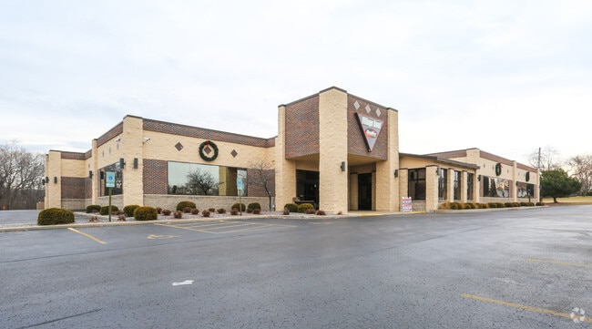
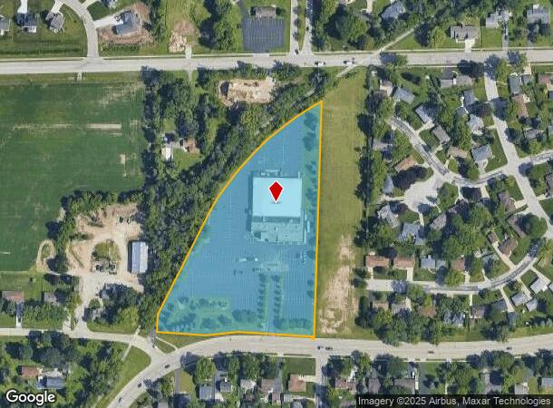
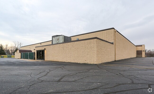
Property Record
N86w18330 Main St, Menomonee Falls, WI 53051
NEARBY LISTINGS FOR SALE OR LEASE
Property Detail
N86w18330 Main St
MNFV-0034-997-001
PT NW1/4 SEC 9 T8N R20E COM NE CRNR S872441W 780.50 FT S572338W 230.67 FT TO THE POINT OF BGN; S00819E 747.28 FT; N883308W 6.70 FT; N012652E 5.00 FT; N883308W 233.49 FT; S824637W 101.16 FT; N883308W 167.42 FT; N001144E 50.83 FT; N262314E 361.14 FT NE
Commercialnec
Waukesha
X
Wisconsin
55133C0092H
8
2024
5.49 AC
2024
NE/Menomonee Falls
200101
Milwaukee/Madison
36,365 SF
Milwaukee-Waukesha-West Allis, WI
DEMOGRAPHICS near N86w18330 Main St
1 Mile
3 Mile
5 Mile
2024 Total Population
5,527
28,143
66,125
2029 Population
5,504
28,207
66,164
Pop Growth 2024-2029
(0.42%)
+ 0.23%
+ 0.06%
Average Age
42
44
43
2024 Total Households
2,369
12,079
27,185
HH Growth 2024-2029
(0.51%)
+ 0.23%
(0.09%)
Median Household Inc
$81,980
$86,091
$93,762
Avg Household Size
2.30
2.30
2.40
2024 Avg HH Vehicles
2.00
2.00
2.00
Median Home Value
$256,089
$280,933
$311,082
Median Year Built
1965
1975
1983
Nearby Places
Map Layers
Map Styles
 Street
 Aerial
- Restaurants
- Banks
- Shops
- Fitness
- Groceries
PUBLIC TRANSPORTATION
AIRPORT
General Mitchell International
DRIVE
WALK
Distance
General Mitchell International
43 min
25.8 mi
Freight Ports
Port Milwaukee
DRIVE
WALK
Distance
Port Milwaukee
37 min
22.1 mi
Nearby Properties
Address
Land Use
TOTAL SIZE
Lot Size
Zoning
Address
Land Use
TOTAL SIZE
Lot Size
Zoning
244,996 SF
16.82 AC
Address
Land Use
TOTAL SIZE
Lot Size
Zoning
145,836 SF
11 AC
Address
Land Use
TOTAL SIZE
Lot Size
Zoning
294,486 SF
12.78 AC
Address
Land Use
TOTAL SIZE
Lot Size
Zoning
Address
Land Use
TOTAL SIZE
Lot Size
Zoning
211,754 SF
30.52 AC
Address
Land Use
TOTAL SIZE
Lot Size
Zoning
36,042 SF
4.51 AC
Address
Land Use
TOTAL SIZE
Lot Size
Zoning
186,372 SF
22.16 AC
Address
Land Use
TOTAL SIZE
Lot Size
Zoning
Address
Land Use
TOTAL SIZE
Lot Size
Zoning
94,698 SF
10.67 AC
Address
Land Use
TOTAL SIZE
Lot Size
Zoning
91,708 SF
6.66 AC
Address
Land Use
TOTAL SIZE
Lot Size
Zoning
204,175 SF
2.48 AC
Address
Land Use
TOTAL SIZE
Lot Size
Zoning
147,240 SF
2.53 AC
Address
Land Use
TOTAL SIZE
Lot Size
Zoning
147,240 SF
3.06 AC
Address
Land Use
TOTAL SIZE
Lot Size
Zoning
104,642 SF
7.06 AC
Address
Land Use
TOTAL SIZE
Lot Size
Zoning
302,895 SF
7.90 AC
Address
Land Use
TOTAL SIZE
Lot Size
Zoning
245,615 SF
15.88 AC
Address
Land Use
TOTAL SIZE
Lot Size
Zoning
127,496 SF
2.88 AC
Address
Land Use
TOTAL SIZE
Lot Size
Zoning
147,987 SF
15.23 AC
Address
Land Use
TOTAL SIZE
Lot Size
Zoning
152,006 SF
12.92 AC
Address
Land Use
TOTAL SIZE
Lot Size
Zoning
153,383 SF
17.43 AC
Address
Land Use
TOTAL SIZE
Lot Size
Zoning
Address
Land Use
TOTAL SIZE
Lot Size
Zoning
53,681 SF
38.43 AC
Address
Land Use
TOTAL SIZE
Lot Size
Zoning
14.12 AC
Address
Land Use
TOTAL SIZE
Lot Size
Zoning
125,857 SF
13.99 AC
Address
Land Use
TOTAL SIZE
Lot Size
Zoning
63,916 SF
1.99 AC
Address
Land Use
TOTAL SIZE
Lot Size
Zoning
89,808 SF
2.70 AC
Address
Land Use
TOTAL SIZE
Lot Size
Zoning
202,250 SF
9.80 AC
Address
Land Use
TOTAL SIZE
Lot Size
Zoning
62,936 SF
2.71 AC
Address
Land Use
TOTAL SIZE
Lot Size
Zoning
104,636 SF
11.97 AC
Address
Land Use
TOTAL SIZE
Lot Size
Zoning
The World's #1 Commercial Real Estate Marketplace
Connect with us
© 2025 CoStar Group
The information above has been obtained from sources believed reliable. While we do not doubt its accuracy we have not verified it and make no guarantee, warranty or representation about it. It is your responsibility to independently confirm its accuracy and completeness. Any projections, opinions, assumptions, or estimates used are for example only and do not represent the current or future performance of the property. The value of this transaction to you depends on tax and other factors which should be evaluated by your tax, financial, and legal advisors. You and your advisors should conduct a careful, independent investigation of the property to determine to your satisfaction the suitability of the property for your needs.