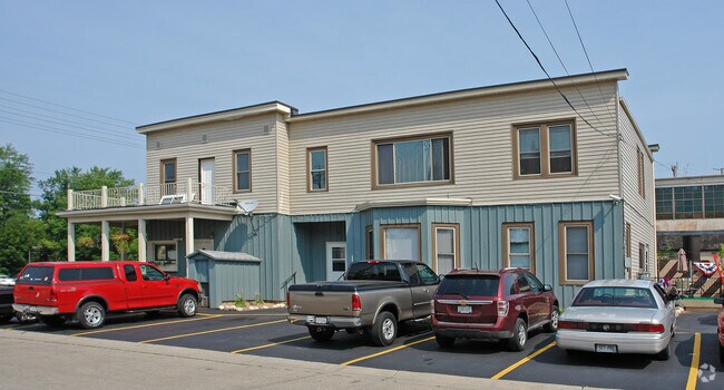
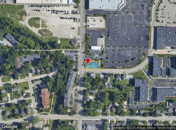
Property Record
N91w16356 Pershing Ave, Menomonee Falls, WI 53051

NEARBY LISTINGS FOR SALE OR LEASE
Property Detail
N91w16356 Pershing Ave
Milwaukee-Waukesha-West Allis, WI
Camps Additioncamps Additioncamps Additi
MNFV-0012-018-002
PT SE1/4 SEC 3 T8N R20E; COM AT PNT WHERE E LINE OF HWY WHICH RUNS N & S ALNG W LINE OF 1/4 SEC INTERSEC S LINE RR; E ALNG S LINE OF RR 160 FT; S & PARALLEL WITH W LINE OF 1/4 SEC 120 FT; W & PARALLEL TO FIRST DESC LINE 160 FT; N 120 FT TO BGN :: EX
Commercialnec
Waukesha
X
Wisconsin
55089C0240G
8,1,2
2024
0.24 AC
2024
NE/Menomonee Falls
200102
Milwaukee/Madison
7,826 SF
DEMOGRAPHICS near N91w16356 Pershing Ave
1 Mile
3 Mile
5 Mile
2024 Total Population
9,163
35,143
71,810
2029 Population
9,047
34,981
71,569
Pop Growth 2024-2029
(1.27%)
(0.46%)
(0.34%)
Average Age
42
44
42
2024 Total Households
4,148
15,241
29,412
HH Growth 2024-2029
(1.40%)
(0.51%)
(0.42%)
Median Household Inc
$83,392
$85,842
$83,106
Avg Household Size
2.20
2.30
2.40
2024 Avg HH Vehicles
2.00
2.00
2.00
Median Home Value
$259,100
$283,119
$291,231
Median Year Built
1967
1979
1980
Nearby Places
- Restaurants
- Banks
- Shops
- Fitness
- Groceries
PUBLIC TRANSPORTATION
AIRPORT
General Mitchell International
DRIVE
WALK
Distance
General Mitchell International
40 min
25.5 mi
Freight Ports
Port Milwaukee
DRIVE
WALK
Distance
Port Milwaukee
34 min
21.7 mi
SALE & LEASE HISTORY
LISTING DATE
SALE/LEASE

Apr 02, 2024
For Lease
Nearby Properties
Address
Land Use
TOTAL SIZE
Lot Size
Zoning
Address
Land Use
TOTAL SIZE
Lot Size
Zoning
244,996 SF
16.82 AC
Address
Land Use
TOTAL SIZE
Lot Size
Zoning
145,836 SF
11 AC
Address
Land Use
TOTAL SIZE
Lot Size
Zoning
294,486 SF
12.78 AC
Address
Land Use
TOTAL SIZE
Lot Size
Zoning
530,458 SF
26.32 AC
Address
Land Use
TOTAL SIZE
Lot Size
Zoning
Address
Land Use
TOTAL SIZE
Lot Size
Zoning
211,754 SF
30.52 AC
Address
Land Use
TOTAL SIZE
Lot Size
Zoning
36,042 SF
4.51 AC
Address
Land Use
TOTAL SIZE
Lot Size
Zoning
186,372 SF
22.16 AC
Address
Land Use
TOTAL SIZE
Lot Size
Zoning
292,944 SF
17.32 AC
Address
Land Use
TOTAL SIZE
Lot Size
Zoning
Address
Land Use
TOTAL SIZE
Lot Size
Zoning
94,698 SF
10.67 AC
Address
Land Use
TOTAL SIZE
Lot Size
Zoning
91,708 SF
6.66 AC
Address
Land Use
TOTAL SIZE
Lot Size
Zoning
204,175 SF
2.48 AC
Address
Land Use
TOTAL SIZE
Lot Size
Zoning
147,240 SF
2.53 AC
Address
Land Use
TOTAL SIZE
Lot Size
Zoning
147,240 SF
3.06 AC
Address
Land Use
TOTAL SIZE
Lot Size
Zoning
23.77 AC
Address
Land Use
TOTAL SIZE
Lot Size
Zoning
104,642 SF
7.06 AC
Address
Land Use
TOTAL SIZE
Lot Size
Zoning
302,895 SF
7.90 AC
Address
Land Use
TOTAL SIZE
Lot Size
Zoning
245,615 SF
15.88 AC
Address
Land Use
TOTAL SIZE
Lot Size
Zoning
24.02 AC
Address
Land Use
TOTAL SIZE
Lot Size
Zoning
142,177 SF
2.60 AC
Address
Land Use
TOTAL SIZE
Lot Size
Zoning
241,880 SF
17.39 AC
Address
Land Use
TOTAL SIZE
Lot Size
Zoning
12.23 AC
Address
Land Use
TOTAL SIZE
Lot Size
Zoning
Address
Land Use
TOTAL SIZE
Lot Size
Zoning
378,511 SF
22.19 AC
Address
Land Use
TOTAL SIZE
Lot Size
Zoning
127,496 SF
2.88 AC
Address
Land Use
TOTAL SIZE
Lot Size
Zoning
147,987 SF
15.23 AC
Address
Land Use
TOTAL SIZE
Lot Size
Zoning
419,659 SF
33.55 AC
IL1
Address
Land Use
TOTAL SIZE
Lot Size
Zoning
152,006 SF
12.92 AC
Address
Land Use
TOTAL SIZE
Lot Size
Zoning
153,383 SF
17.43 AC
The World's #1 Commercial Real Estate Marketplace
Connect with us
© 2025 CoStar Group
The information above has been obtained from sources believed reliable. While we do not doubt its accuracy we have not verified it and make no guarantee, warranty or representation about it. It is your responsibility to independently confirm its accuracy and completeness. Any projections, opinions, assumptions, or estimates used are for example only and do not represent the current or future performance of the property. The value of this transaction to you depends on tax and other factors which should be evaluated by your tax, financial, and legal advisors. You and your advisors should conduct a careful, independent investigation of the property to determine to your satisfaction the suitability of the property for your needs.