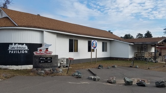
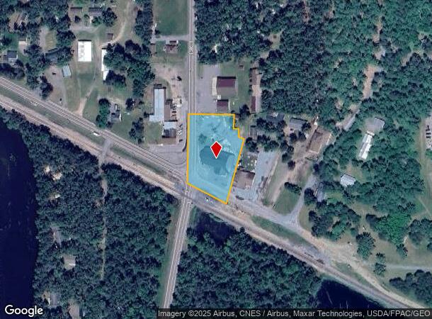
Property Record
N9501 Thunderbird Ln, Merrillan, WI 54754
NEARBY LISTINGS FOR SALE OR LEASE
-
-
View all Merrillan listings for sale on LoopNet.com
Property Detail
N9501 Thunderbird Ln
Other Market Areas
1922 Assessors Map Of Outlots
002-0229.0020
LOT 4 CSM 4472
Commercialnec
Jackson
X
Wisconsin
55053C0211C
4
2024
1.38 AC
2024
Eau Claire/Menomonie
960200
DEMOGRAPHICS near N9501 Thunderbird Ln
1 mile
3 mile
5 mile
2024 Total Population
411
968
1,266
2029 Population
410
967
1,262
Pop Growth 2024-2029
(0.24%)
(0.10%)
(0.32%)
Average Age
48
48
47
2024 Total Households
190
451
579
HH Growth 2024-2029
(0.53%)
0.00%
(0.17%)
Median Household Inc
$64,166
$59,387
$59,153
Avg Household Size
2.20
2.10
2.20
2024 Avg HH Vehicles
2.00
2.00
2.00
Median Home Value
$203,030
$201,493
$194,535
Median Year Built
1987
1984
1983
Nearby Places
Map Layers
Map Styles
 Street
 Aerial
Transit
 Traffic
 Biking
Places
Listings with unknown addresses are not visible on the map
- Restaurants
- Banks
- Shops
- Fitness
- Groceries
SALE & LEASE HISTORY
LISTING DATE
SALE/LEASE

Jan 17, 2019
For Sale
Nearby Properties
Address
Land Use
TOTAL SIZE
Lot Size
Zoning
Address
Land Use
TOTAL SIZE
Lot Size
Zoning
1.44 AC
Address
Land Use
TOTAL SIZE
Lot Size
Zoning
5.46 AC
Address
Land Use
TOTAL SIZE
Lot Size
Zoning
Address
Land Use
TOTAL SIZE
Lot Size
Zoning
2.54 AC
Address
Land Use
TOTAL SIZE
Lot Size
Zoning
1.97 AC
Address
Land Use
TOTAL SIZE
Lot Size
Zoning
1.04 AC
Address
Land Use
TOTAL SIZE
Lot Size
Zoning
0.93 AC
Address
Land Use
TOTAL SIZE
Lot Size
Zoning
1.18 AC
Address
Land Use
TOTAL SIZE
Lot Size
Zoning
2.19 AC
Address
Land Use
TOTAL SIZE
Lot Size
Zoning
1.15 AC
Address
Land Use
TOTAL SIZE
Lot Size
Zoning
1.13 AC
Address
Land Use
TOTAL SIZE
Lot Size
Zoning
1.12 AC
Address
Land Use
TOTAL SIZE
Lot Size
Zoning
0.73 AC
Address
Land Use
TOTAL SIZE
Lot Size
Zoning
0.88 AC
Address
Land Use
TOTAL SIZE
Lot Size
Zoning
1.58 AC
Address
Land Use
TOTAL SIZE
Lot Size
Zoning
11.32 AC
R2
Address
Land Use
TOTAL SIZE
Lot Size
Zoning
Address
Land Use
TOTAL SIZE
Lot Size
Zoning
1.25 AC
Address
Land Use
TOTAL SIZE
Lot Size
Zoning
Address
Land Use
TOTAL SIZE
Lot Size
Zoning
Address
Land Use
TOTAL SIZE
Lot Size
Zoning
0.95 AC
Address
Land Use
TOTAL SIZE
Lot Size
Zoning
2.29 AC
Address
Land Use
TOTAL SIZE
Lot Size
Zoning
Address
Land Use
TOTAL SIZE
Lot Size
Zoning
0.71 AC
Address
Land Use
TOTAL SIZE
Lot Size
Zoning
1.50 AC
Address
Land Use
TOTAL SIZE
Lot Size
Zoning
0.96 AC
Address
Land Use
TOTAL SIZE
Lot Size
Zoning
0.99 AC
R2
Address
Land Use
TOTAL SIZE
Lot Size
Zoning
Address
Land Use
TOTAL SIZE
Lot Size
Zoning
1.23 AC
Address
Land Use
TOTAL SIZE
Lot Size
Zoning
1.21 AC
The World's #1 Commercial Real Estate Marketplace
Connect with us
© 2026 CoStar Group
The information above has been obtained from sources believed reliable. While we do not doubt its accuracy we have not verified it and make no guarantee, warranty or representation about it. It is your responsibility to independently confirm its accuracy and completeness. Any projections, opinions, assumptions, or estimates used are for example only and do not represent the current or future performance of the property. The value of this transaction to you depends on tax and other factors which should be evaluated by your tax, financial, and legal advisors. You and your advisors should conduct a careful, independent investigation of the property to determine to your satisfaction the suitability of the property for your needs.