Property Record
Nall Rd, Bucyrus, KS 66013
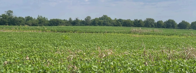

This Property Is For Sale
NEARBY LISTINGS FOR SALE OR LEASE
Property Detail
Nall Rd
014-20-0-00-00-013.00-0
S20, T15, R25, ACRES 9.86, E890 OF N495 OF SE4 LESS ROW
Agriculturalland
Miami
X
Kansas
20121C0085D
9.86 AC
2025
Outer South Kansas City
2025
Kansas City
053804
Kansas City, MO-KS
DEMOGRAPHICS near Nall Rd
1 Mile
3 Mile
5 Mile
2024 Total Population
173
2,322
6,889
2029 Population
177
2,394
7,192
Pop Growth 2024-2029
+ 2.31%
+ 3.10%
+ 4.40%
Average Age
44
43
43
2024 Total Households
61
829
2,432
HH Growth 2024-2029
+ 3.28%
+ 3.26%
+ 4.52%
Median Household Inc
$154,167
$131,316
$129,515
Avg Household Size
2.70
2.70
2.80
2024 Avg HH Vehicles
3.00
3.00
3.00
Median Home Value
$641,666
$497,265
$541,761
Median Year Built
1983
1982
1987
Nearby Places
- Restaurants
- Banks
- Shops
- Fitness
- Groceries
Nearby Properties
Address
Land Use
TOTAL SIZE
Lot Size
Zoning
Address
Land Use
TOTAL SIZE
Lot Size
Zoning
71,610 SF
6.11 AC
RN1
Address
Land Use
TOTAL SIZE
Lot Size
Zoning
48,165 SF
5.79 AC
RUR
Address
Land Use
TOTAL SIZE
Lot Size
Zoning
12,112 SF
5.50 AC
RN1
Address
Land Use
TOTAL SIZE
Lot Size
Zoning
45.23 AC
RUR
Address
Land Use
TOTAL SIZE
Lot Size
Zoning
9,800 SF
15.74 AC
PEC3
Address
Land Use
TOTAL SIZE
Lot Size
Zoning
16,108 SF
68.40 AC
RN2
Address
Land Use
TOTAL SIZE
Lot Size
Zoning
8,496 SF
10 AC
RUR
Address
Land Use
TOTAL SIZE
Lot Size
Zoning
8,816 SF
0.49 AC
PRB1A
Address
Land Use
TOTAL SIZE
Lot Size
Zoning
23,230 SF
6.38 AC
PEC3
Address
Land Use
TOTAL SIZE
Lot Size
Zoning
17,366 SF
52.91 AC
RUR
Address
Land Use
TOTAL SIZE
Lot Size
Zoning
6,388 SF
9.64 AC
RUR
Address
Land Use
TOTAL SIZE
Lot Size
Zoning
6,000 SF
6.93 AC
PEC3
Address
Land Use
TOTAL SIZE
Lot Size
Zoning
9.52 AC
RUR
Address
Land Use
TOTAL SIZE
Lot Size
Zoning
4,777 SF
1.45 AC
PRB2
Address
Land Use
TOTAL SIZE
Lot Size
Zoning
4,641 SF
2.10 AC
PRB2
Address
Land Use
TOTAL SIZE
Lot Size
Zoning
9,044 SF
1.09 AC
PEC3
Address
Land Use
TOTAL SIZE
Lot Size
Zoning
4,104 SF
2.23 AC
PRB2
Address
Land Use
TOTAL SIZE
Lot Size
Zoning
11,983 SF
14.75 AC
RUR
Address
Land Use
TOTAL SIZE
Lot Size
Zoning
8,694 SF
1.23 AC
PRB2
Address
Land Use
TOTAL SIZE
Lot Size
Zoning
2,887 SF
2.37 AC
PRB2
Address
Land Use
TOTAL SIZE
Lot Size
Zoning
8,400 SF
5.56 AC
PEC3
Address
Land Use
TOTAL SIZE
Lot Size
Zoning
9,702 SF
159.26 AC
RUR
Address
Land Use
TOTAL SIZE
Lot Size
Zoning
11,044 SF
11.50 AC
RUR
Address
Land Use
TOTAL SIZE
Lot Size
Zoning
8,400 SF
6.17 AC
PEC3
Address
Land Use
TOTAL SIZE
Lot Size
Zoning
7,168 SF
0.96 AC
PEC3
Address
Land Use
TOTAL SIZE
Lot Size
Zoning
7,254 SF
7.23 AC
PEC3
Address
Land Use
TOTAL SIZE
Lot Size
Zoning
9,747 SF
0.83 AC
PEC3
Address
Land Use
TOTAL SIZE
Lot Size
Zoning
8,002 SF
22.45 AC
RN1
Address
Land Use
TOTAL SIZE
Lot Size
Zoning
3,600 SF
2.39 AC
PRB2
Address
Land Use
TOTAL SIZE
Lot Size
Zoning
10,003 SF
29.94 AC
RUR
The World's #1 Commercial Real Estate Marketplace
Connect with us
© 2025 CoStar Group
The information above has been obtained from sources believed reliable. While we do not doubt its accuracy we have not verified it and make no guarantee, warranty or representation about it. It is your responsibility to independently confirm its accuracy and completeness. Any projections, opinions, assumptions, or estimates used are for example only and do not represent the current or future performance of the property. The value of this transaction to you depends on tax and other factors which should be evaluated by your tax, financial, and legal advisors. You and your advisors should conduct a careful, independent investigation of the property to determine to your satisfaction the suitability of the property for your needs.