Property Record
Nana Hope St, Ewa Beach, HI 96706
NEARBY LISTINGS FOR SALE OR LEASE
Property Detail
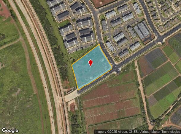
Nana Hope St
Urban Honolulu, HI
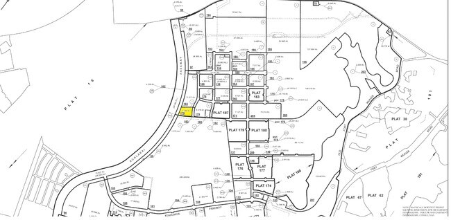
LOT 3 HOOPILI PHASE 6 LG LOT SUBD FP 2526 3.349 ACRES TOG/ESMT SUBJ/ESMTS/RESTRICTION OF VEHICLE ACCESS
1-9-1-017-178-0000
Honolulu
Resorthotel
Hawaii
D
3
15003C0310G
3.35 AC
2024
West Oahu
2025
Hawaii
008627
DEMOGRAPHICS near Nana Hope St
1 Mile
3 Mile
5 Mile
2024 Total Population
10,356
101,207
152,631
2029 Population
10,013
96,813
145,666
Pop Growth 2024-2029
(3.31%)
(4.34%)
(4.56%)
Average Age
32
37
38
2024 Total Households
2,682
28,515
42,138
HH Growth 2024-2029
(4.03%)
(4.87%)
(5.19%)
Median Household Inc
$111,669
$110,385
$108,403
Avg Household Size
3.70
3.30
3.40
2024 Avg HH Vehicles
2.00
2.00
2.00
Median Home Value
$734,489
$718,534
$721,822
Median Year Built
2009
1997
1995
Nearby Places
Map Layers
Map Styles
 Street
 Aerial
- Restaurants
- Banks
- Shops
- Fitness
- Groceries
PUBLIC TRANSPORTATION
TRANSIT/SUBWAY
Keone'ae U.H. West Oahu Station (SKYLINE - DTS)
DRIVE
WALK
Distance
Keone'ae U.H. West Oahu Station (SKYLINE - DTS)
1 min
9 min
0.5 mi
AIRPORT
Daniel K Inouye International
DRIVE
WALK
Distance
Daniel K Inouye International
23 min
15.2 mi
Freight Ports
Honolulu Harbor, Oahu
DRIVE
WALK
Distance
Honolulu Harbor, Oahu
31 min
19.4 mi
Nearby Properties
Address
Land Use
TOTAL SIZE
Lot Size
Zoning
Address
Land Use
TOTAL SIZE
Lot Size
Zoning
310,432 SF
192.56 AC
BMX-3
Address
Land Use
TOTAL SIZE
Lot Size
Zoning
645,869 SF
48.95 AC
AG-1
Address
Land Use
TOTAL SIZE
Lot Size
Zoning
48.66 AC
I-2
Address
Land Use
TOTAL SIZE
Lot Size
Zoning
82,948 SF
16.06 AC
AG-1
Address
Land Use
TOTAL SIZE
Lot Size
Zoning
229,396 SF
11.31 AC
BMX-3
Address
Land Use
TOTAL SIZE
Lot Size
Zoning
2,225 SF
19.72 AC
AG-1
Address
Land Use
TOTAL SIZE
Lot Size
Zoning
222,228 SF
7.15 AC
B-2
Address
Land Use
TOTAL SIZE
Lot Size
Zoning
238,418 SF
9.46 AC
F-1
Address
Land Use
TOTAL SIZE
Lot Size
Zoning
158,113 SF
21.79 AC
B-2
Address
Land Use
TOTAL SIZE
Lot Size
Zoning
1,714 SF
200.33 AC
AG-1
Address
Land Use
TOTAL SIZE
Lot Size
Zoning
63,936 SF
62.24 AC
F-1
Address
Land Use
TOTAL SIZE
Lot Size
Zoning
208,386 SF
2.84 AC
B-2
Address
Land Use
TOTAL SIZE
Lot Size
Zoning
139,755 SF
18.79 AC
B-2
Address
Land Use
TOTAL SIZE
Lot Size
Zoning
13.47 AC
AMX-2
Address
Land Use
TOTAL SIZE
Lot Size
Zoning
29.14 AC
IMX-1
Address
Land Use
TOTAL SIZE
Lot Size
Zoning
38.08 AC
A/51/50
Address
Land Use
TOTAL SIZE
Lot Size
Zoning
9,768 SF
48.81 AC
F-1
Address
Land Use
TOTAL SIZE
Lot Size
Zoning
424,593 SF
8.73 AC
B-2
Address
Land Use
TOTAL SIZE
Lot Size
Zoning
74,111 SF
26.27 AC
U/63/80
Address
Land Use
TOTAL SIZE
Lot Size
Zoning
136,868 SF
2.84 AC
B-2
Address
Land Use
TOTAL SIZE
Lot Size
Zoning
41,964 SF
69.57 AC
F-1
Address
Land Use
TOTAL SIZE
Lot Size
Zoning
157,460 SF
9.51 AC
BMX-3
Address
Land Use
TOTAL SIZE
Lot Size
Zoning
24,364 SF
B-2
Address
Land Use
TOTAL SIZE
Lot Size
Zoning
106,692 SF
5.02 AC
BMX-3
Address
Land Use
TOTAL SIZE
Lot Size
Zoning
105,618 SF
4.99 AC
BMX-3
Address
Land Use
TOTAL SIZE
Lot Size
Zoning
18,943 SF
B-2
Address
Land Use
TOTAL SIZE
Lot Size
Zoning
18,472 SF
22.07 AC
F-1
Address
Land Use
TOTAL SIZE
Lot Size
Zoning
14,608 SF
20.60 AC
F-1
Address
Land Use
TOTAL SIZE
Lot Size
Zoning
79,561 SF
1.40 AC
BMX-3
The World's #1 Commercial Real Estate Marketplace
Connect with us
© 2025 CoStar Group
The information above has been obtained from sources believed reliable. While we do not doubt its accuracy we have not verified it and make no guarantee, warranty or representation about it. It is your responsibility to independently confirm its accuracy and completeness. Any projections, opinions, assumptions, or estimates used are for example only and do not represent the current or future performance of the property. The value of this transaction to you depends on tax and other factors which should be evaluated by your tax, financial, and legal advisors. You and your advisors should conduct a careful, independent investigation of the property to determine to your satisfaction the suitability of the property for your needs.