Property Record
Nandina St, Devore Heights, CA 92407

Property Detail
Nandina St
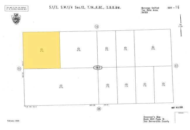
0611-161-01
NW 1/4 SW 1/4 SW 1/4 SEC 12 TP 1N R 8E
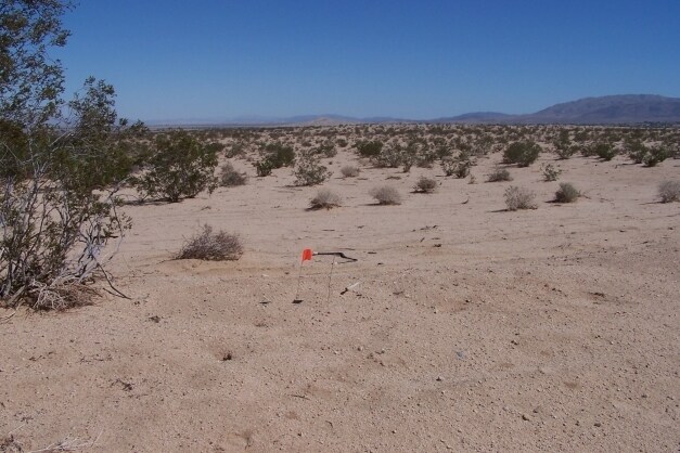
Vacantlandnec
SAN BERNARDINO
RL5
California
D Areas with possible but undetermined flood hazards.
10 AC
2025
Twentynine Palms
2025
Inland Empire (California)
004601
Riverside-San Bernardino-Ontario, CA
NEARBY LISTINGS FOR SALE OR LEASE
DEMOGRAPHICS near Nandina St
1 mile
3 mile
5 mile
2025 Total Population
205
5,211
29,914
2030 Population
216
5,382
30,727
Pop Growth 2025-2030
+ 5.37%
+ 3.28%
+ 2.72%
Average Age
46
38
33
2025 Total Households
89
2,069
9,362
HH Growth 2025-2030
+ 5.62%
+ 3.29%
+ 3.86%
Median Household Inc
$65,689
$68,337
$57,846
Avg Household Size
2.20
2.50
2.50
2025 Avg HH Vehicles
2.00
2.00
2.00
Median Home Value
$250,000
$281,090
$290,058
Median Year Built
1978
1981
1988
Nearby Places
Map Layers
Map Styles
 Street
 Aerial
Transit
 Traffic
 Biking
Places
Listings with unknown addresses are not visible on the map
- Restaurants
- Banks
- Shops
- Fitness
- Groceries
Nearby Properties
Address
Land Use
TOTAL SIZE
Lot Size
Zoning
Address
Land Use
TOTAL SIZE
Lot Size
Zoning
18,735 SF
3.18 AC
Address
Land Use
TOTAL SIZE
Lot Size
Zoning
91.66 AC
Address
Land Use
TOTAL SIZE
Lot Size
Zoning
Address
Land Use
TOTAL SIZE
Lot Size
Zoning
7,886 SF
6.43 AC
Address
Land Use
TOTAL SIZE
Lot Size
Zoning
12,748 SF
4.02 AC
Address
Land Use
TOTAL SIZE
Lot Size
Zoning
18.03 AC
Address
Land Use
TOTAL SIZE
Lot Size
Zoning
316.97 AC
Address
Land Use
TOTAL SIZE
Lot Size
Zoning
3,844 SF
4.81 AC
Address
Land Use
TOTAL SIZE
Lot Size
Zoning
160 AC
Address
Land Use
TOTAL SIZE
Lot Size
Zoning
Address
Land Use
TOTAL SIZE
Lot Size
Zoning
70.82 AC
Address
Land Use
TOTAL SIZE
Lot Size
Zoning
1,105 SF
4.14 AC
Address
Land Use
TOTAL SIZE
Lot Size
Zoning
Address
Land Use
TOTAL SIZE
Lot Size
Zoning
900 SF
4.11 AC
Address
Land Use
TOTAL SIZE
Lot Size
Zoning
73.31 AC
Address
Land Use
TOTAL SIZE
Lot Size
Zoning
10 AC
Address
Land Use
TOTAL SIZE
Lot Size
Zoning
960 SF
1.14 AC
Address
Land Use
TOTAL SIZE
Lot Size
Zoning
5,902 SF
8.89 AC
Address
Land Use
TOTAL SIZE
Lot Size
Zoning
80 AC
RL
Address
Land Use
TOTAL SIZE
Lot Size
Zoning
Address
Land Use
TOTAL SIZE
Lot Size
Zoning
80.18 AC
Address
Land Use
TOTAL SIZE
Lot Size
Zoning
4,500 SF
4.39 AC
Address
Land Use
TOTAL SIZE
Lot Size
Zoning
4,309 SF
1.03 AC
Address
Land Use
TOTAL SIZE
Lot Size
Zoning
78.44 AC
Address
Land Use
TOTAL SIZE
Lot Size
Zoning
8.18 AC
Address
Land Use
TOTAL SIZE
Lot Size
Zoning
9.15 AC
Address
Land Use
TOTAL SIZE
Lot Size
Zoning
4.74 AC
Address
Land Use
TOTAL SIZE
Lot Size
Zoning
1,134 SF
0.63 AC
Address
Land Use
TOTAL SIZE
Lot Size
Zoning
120 AC
RL5
Address
Land Use
TOTAL SIZE
Lot Size
Zoning
40 AC
The World's #1 Commercial Real Estate Marketplace
Connect with us
© 2026 CoStar Group
The information above has been obtained from sources believed reliable. While we do not doubt its accuracy we have not verified it and make no guarantee, warranty or representation about it. It is your responsibility to independently confirm its accuracy and completeness. Any projections, opinions, assumptions, or estimates used are for example only and do not represent the current or future performance of the property. The value of this transaction to you depends on tax and other factors which should be evaluated by your tax, financial, and legal advisors. You and your advisors should conduct a careful, independent investigation of the property to determine to your satisfaction the suitability of the property for your needs.