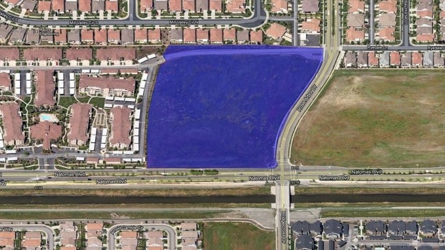
Property Record
5651 Natomas Blvd, Sacramento, CA 95835
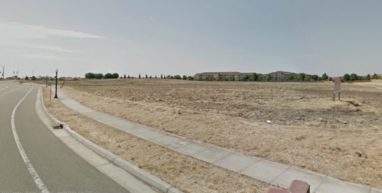

This Property Is For Sale
NEARBY LISTINGS FOR SALE OR LEASE
Property Detail
5651 Natomas Blvd
Sacramento--Roseville--Arden-Arcade, CA
Parcel Map
201-0440-077
LOT95 HERITAGE NATOMAS PARK VILLAGE 18
Recreationalacreage
Sacramento
A99
California
06067C0045J
30
2024
4.60 AC
2025
North Natomas
007110
Sacramento
DEMOGRAPHICS near 5651 Natomas Blvd
1 Mile
3 Mile
5 Mile
2024 Total Population
17,492
64,301
159,754
2029 Population
17,583
65,165
161,299
Pop Growth 2024-2029
+ 0.52%
+ 1.34%
+ 0.97%
Average Age
40
38
37
2024 Total Households
6,305
22,725
53,395
HH Growth 2024-2029
+ 0.54%
+ 1.38%
+ 0.97%
Median Household Inc
$101,954
$106,314
$90,318
Avg Household Size
2.80
2.80
2.90
2024 Avg HH Vehicles
2.00
2.00
2.00
Median Home Value
$491,723
$495,192
$454,496
Median Year Built
2004
2004
1999
Nearby Places
Map Layers
Map Styles
 Street
 Aerial
- Restaurants
- Banks
- Shops
- Fitness
- Groceries
PUBLIC TRANSPORTATION
COMMUTER RAIL
Sacramento (Capitol Corridor - Capitol Corridor Joint Powers Authority)
DRIVE
WALK
Distance
Sacramento (Capitol Corridor - Capitol Corridor Joint Powers Authority)
14 min
8.9 mi
AIRPORT
Sacramento International
DRIVE
WALK
Distance
Sacramento International
14 min
7.5 mi
Freight Ports
Port of Stockton
DRIVE
WALK
Distance
Port of Stockton
65 min
54.8 mi
Nearby Properties
Address
Land Use
TOTAL SIZE
Lot Size
Zoning
Address
Land Use
TOTAL SIZE
Lot Size
Zoning
363,761 SF
10.34 AC
SC-PUD
Address
Land Use
TOTAL SIZE
Lot Size
Zoning
522,025 SF
65.80 AC
SC-PUD EC-
Address
Land Use
TOTAL SIZE
Lot Size
Zoning
153,090 SF
7.77 AC
MP
Address
Land Use
TOTAL SIZE
Lot Size
Zoning
343,500 SF
12.68 AC
R-2B-R-PUD
Address
Land Use
TOTAL SIZE
Lot Size
Zoning
100.41 AC
C-2-PUD
Address
Land Use
TOTAL SIZE
Lot Size
Zoning
241,321 SF
14.43 AC
R-3-PUD
Address
Land Use
TOTAL SIZE
Lot Size
Zoning
388,609 SF
14.67 AC
R-3-PUD
Address
Land Use
TOTAL SIZE
Lot Size
Zoning
17.55 AC
SPA
Address
Land Use
TOTAL SIZE
Lot Size
Zoning
429,346 SF
18.88 AC
R-2B-PUD E
Address
Land Use
TOTAL SIZE
Lot Size
Zoning
131.26 AC
SPA
Address
Land Use
TOTAL SIZE
Lot Size
Zoning
298,493 SF
18.56 AC
EC-40-PUD
Address
Land Use
TOTAL SIZE
Lot Size
Zoning
195,928 SF
8.62 AC
EC-40-PUD
Address
Land Use
TOTAL SIZE
Lot Size
Zoning
164,061 SF
8.15 AC
R-3-PUD
Address
Land Use
TOTAL SIZE
Lot Size
Zoning
282,292 SF
14.42 AC
R-3-PUD
Address
Land Use
TOTAL SIZE
Lot Size
Zoning
6.23 AC
EC-50-PUD
Address
Land Use
TOTAL SIZE
Lot Size
Zoning
9.01 AC
EC-80-PUD
Address
Land Use
TOTAL SIZE
Lot Size
Zoning
217,682 SF
9.57 AC
R-3-PUD
Address
Land Use
TOTAL SIZE
Lot Size
Zoning
92,240 SF
5.59 AC
MP
Address
Land Use
TOTAL SIZE
Lot Size
Zoning
209,376 SF
9.14 AC
MP M-1
Address
Land Use
TOTAL SIZE
Lot Size
Zoning
13.90 AC
SC-PUD
Address
Land Use
TOTAL SIZE
Lot Size
Zoning
Address
Land Use
TOTAL SIZE
Lot Size
Zoning
1,784 SF
15.07 AC
M-1
Address
Land Use
TOTAL SIZE
Lot Size
Zoning
222,792 SF
12.50 AC
MP
Address
Land Use
TOTAL SIZE
Lot Size
Zoning
204,999 SF
8.32 AC
R-3-PUD
Address
Land Use
TOTAL SIZE
Lot Size
Zoning
343,355 SF
19.10 AC
MP M-1
Address
Land Use
TOTAL SIZE
Lot Size
Zoning
264,620 SF
0.68 AC
R-4-PUD
Address
Land Use
TOTAL SIZE
Lot Size
Zoning
4.19 AC
EC-65-PUD
Address
Land Use
TOTAL SIZE
Lot Size
Zoning
264,620 SF
8.89 AC
R-4-PUD
Address
Land Use
TOTAL SIZE
Lot Size
Zoning
188,958 SF
6.75 AC
R-3-PUD
Address
Land Use
TOTAL SIZE
Lot Size
Zoning
4.01 AC
C-2-PUD
The World's #1 Commercial Real Estate Marketplace
Connect with us
© 2025 CoStar Group
The information above has been obtained from sources believed reliable. While we do not doubt its accuracy we have not verified it and make no guarantee, warranty or representation about it. It is your responsibility to independently confirm its accuracy and completeness. Any projections, opinions, assumptions, or estimates used are for example only and do not represent the current or future performance of the property. The value of this transaction to you depends on tax and other factors which should be evaluated by your tax, financial, and legal advisors. You and your advisors should conduct a careful, independent investigation of the property to determine to your satisfaction the suitability of the property for your needs.