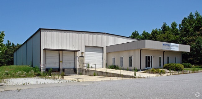
Property Record
2428 Nc Highway 11 N, Kinston, NC 28501

Property Detail
2428 Nc Highway 11 N
453603346751
HWY 11 NORTH MOST WOODS LOW/WET
Timberlandforesttreesagricultural
LENOIR
I1
North Carolina
AE The base floodplain where base flood elevations are provided. AE Zones are now used on new format FIRMs instead of A1-A30 Zones.
31.21 AC
2025
North Carolina Southeast Area
2025
Other Market Areas
010100
Kinston, NC
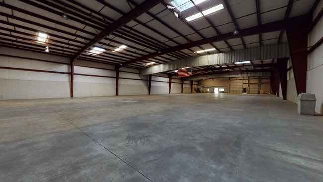
17,010 SF
NEARBY LISTINGS FOR SALE OR LEASE
DEMOGRAPHICS near 2428 Nc Highway 11 N
1 mile
3 mile
5 mile
2025 Total Population
345
14,504
23,776
2030 Population
352
14,877
24,261
Pop Growth 2025-2030
+ 2.03%
+ 2.57%
+ 2.04%
Average Age
45
43
43
2025 Total Households
150
6,401
10,313
HH Growth 2025-2030
+ 2.00%
+ 2.70%
+ 2.13%
Median Household Inc
$39,999
$33,207
$38,391
Avg Household Size
2.30
2.20
2.20
2025 Avg HH Vehicles
3.00
1.00
2.00
Median Home Value
$67,567
$85,818
$105,982
Median Year Built
1980
1966
1969
Nearby Places
Map Layers
Map Styles
 Street
 Aerial
Layers
 Traffic
 Biking
Places
Listings with unknown addresses are not visible on the map
- Restaurants
- Banks
- Shops
- Fitness
- Groceries
PUBLIC TRANSPORTATION
AIRPORT
Pitt-Greenville
Drive
Walk
Distance
Pitt-Greenville
40 min
28.0 mi
Albert J Ellis
Drive
Walk
Distance
Albert J Ellis
68 min
38.3 mi
Coastal Carolina Regional
Drive
Walk
Distance
Coastal Carolina Regional
55 min
41.4 mi
Freight Ports
Port of Morehead City
Drive
Walk
Distance
Port of Morehead City
114 min
79.3 mi
SALE & LEASE HISTORY
LISTING DATE
SALE/LEASE

Nov 10, 2020
For Sale
Jan 28, 2021
For Lease
Feb 13, 2026
For Sale
Nearby Properties
Address
Land Use
TOTAL SIZE
Lot Size
Zoning
Address
Land Use
TOTAL SIZE
Lot Size
Zoning
274,824 SF
54.92 AC
OI
Address
Land Use
TOTAL SIZE
Lot Size
Zoning
114,876 SF
64.24 AC
RA6
Address
Land Use
TOTAL SIZE
Lot Size
Zoning
37,588 SF
111.16 AC
Address
Land Use
TOTAL SIZE
Lot Size
Zoning
191,518 SF
20.71 AC
SC
Address
Land Use
TOTAL SIZE
Lot Size
Zoning
144,099 SF
23.48 AC
RA8
Address
Land Use
TOTAL SIZE
Lot Size
Zoning
119,634 SF
1.86 AC
B2
Address
Land Use
TOTAL SIZE
Lot Size
Zoning
51,934 SF
0.32 AC
B2
Address
Land Use
TOTAL SIZE
Lot Size
Zoning
5,664 SF
407.13 AC
RA6
Address
Land Use
TOTAL SIZE
Lot Size
Zoning
53,768 SF
33.29 AC
I1
Address
Land Use
TOTAL SIZE
Lot Size
Zoning
18,213 SF
159.12 AC
OI
Address
Land Use
TOTAL SIZE
Lot Size
Zoning
23,086 SF
7.39 AC
RA5
Address
Land Use
TOTAL SIZE
Lot Size
Zoning
44,800 SF
9.75 AC
O&I
Address
Land Use
TOTAL SIZE
Lot Size
Zoning
6,178 SF
6.33 AC
RA5
Address
Land Use
TOTAL SIZE
Lot Size
Zoning
11,270 SF
112 AC
RA6
Address
Land Use
TOTAL SIZE
Lot Size
Zoning
64,506 SF
10.64 AC
I1
Address
Land Use
TOTAL SIZE
Lot Size
Zoning
8,640 SF
8.03 AC
RA5
Address
Land Use
TOTAL SIZE
Lot Size
Zoning
83,088 SF
1.19 AC
B2
Address
Land Use
TOTAL SIZE
Lot Size
Zoning
5,206 SF
53.41 AC
IB
Address
Land Use
TOTAL SIZE
Lot Size
Zoning
290,820 SF
25.95 AC
I1
Address
Land Use
TOTAL SIZE
Lot Size
Zoning
3,724 SF
8.84 AC
RA5
Address
Land Use
TOTAL SIZE
Lot Size
Zoning
51,828 SF
7.05 AC
O&I
Address
Land Use
TOTAL SIZE
Lot Size
Zoning
6,760 SF
147.39 AC
RA6
Address
Land Use
TOTAL SIZE
Lot Size
Zoning
7,140 SF
5.04 AC
Address
Land Use
TOTAL SIZE
Lot Size
Zoning
14,651 SF
2.85 AC
B1
Address
Land Use
TOTAL SIZE
Lot Size
Zoning
31,335 SF
9.96 AC
SC
Address
Land Use
TOTAL SIZE
Lot Size
Zoning
8,680 SF
12.35 AC
RA5
Address
Land Use
TOTAL SIZE
Lot Size
Zoning
51,447 SF
5.84 AC
SC
Address
Land Use
TOTAL SIZE
Lot Size
Zoning
78,432 SF
6.66 AC
Address
Land Use
TOTAL SIZE
Lot Size
Zoning
18,716 SF
276.57 AC
RA6
Address
Land Use
TOTAL SIZE
Lot Size
Zoning
37,690 SF
14.26 AC
RO & B1
The World's #1 Commercial Real Estate Marketplace
Connect with us
© 2026 CoStar Group
The information above has been obtained from sources believed reliable. While we do not doubt its accuracy we have not verified it and make no guarantee, warranty or representation about it. It is your responsibility to independently confirm its accuracy and completeness. Any projections, opinions, assumptions, or estimates used are for example only and do not represent the current or future performance of the property. The value of this transaction to you depends on tax and other factors which should be evaluated by your tax, financial, and legal advisors. You and your advisors should conduct a careful, independent investigation of the property to determine to your satisfaction the suitability of the property for your needs.