Property Record
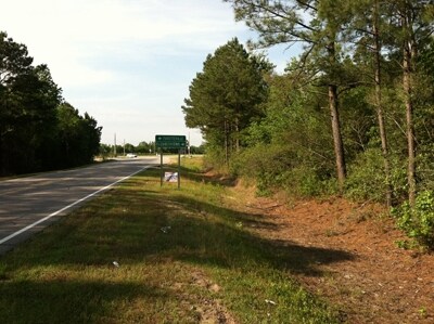
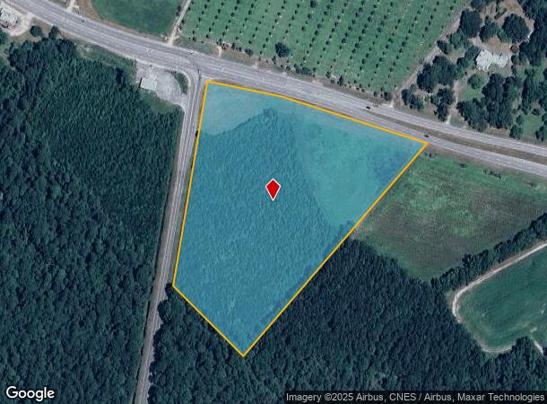
Nc 131 Hwy, Harrells, NC 28444
NEARBY LISTINGS FOR SALE OR LEASE
-
-
View all Harrells listings for sale on LoopNet.com
Property Detail
Nc 131 Hwy
036510465559
036510465559 FR MINNIE MYERS CANADY NC HWY 131
Residentialacreage
Bladen
X
North Carolina
3720036400J
10.67 AC
2025
North Carolina Southeast Area
2025
Other Market Areas
971003
DEMOGRAPHICS near Nc 131 Hwy
1 Mile
3 Mile
5 Mile
2024 Total Population
161
959
2,409
2029 Population
158
947
2,382
Pop Growth 2024-2029
(1.86%)
(1.25%)
(1.12%)
Average Age
44
43
42
2024 Total Households
69
403
989
HH Growth 2024-2029
(2.90%)
(1.24%)
(1.11%)
Median Household Inc
$31,071
$31,923
$34,796
Avg Household Size
2.30
2.40
2.40
2024 Avg HH Vehicles
2.00
2.00
2.00
Median Home Value
$103,704
$107,025
$106,122
Median Year Built
1960
1980
1986
Nearby Places
Map Layers
Map Styles
 Street
 Aerial
- Restaurants
- Banks
- Shops
- Fitness
- Groceries
PUBLIC TRANSPORTATION
AIRPORT
Fayetteville Regional/Grannis Field
DRIVE
WALK
Distance
Fayetteville Regional/Grannis Field
35 min
23.9 mi
Freight Ports
Port of Wilmington
DRIVE
WALK
Distance
Port of Wilmington
92 min
66.2 mi
SALE & LEASE HISTORY
LISTING DATE
SALE/LEASE

Oct 24, 2018
For Sale
Nearby Properties
Address
Land Use
TOTAL SIZE
Lot Size
Zoning
Address
Land Use
TOTAL SIZE
Lot Size
Zoning
353,250 SF
539.31 AC
I
Address
Land Use
TOTAL SIZE
Lot Size
Zoning
118,176 SF
16.90 AC
I
Address
Land Use
TOTAL SIZE
Lot Size
Zoning
12,447 SF
309.74 AC
I
Address
Land Use
TOTAL SIZE
Lot Size
Zoning
13,986 SF
12.65 AC
RA
Address
Land Use
TOTAL SIZE
Lot Size
Zoning
7,212 SF
4.52 AC
RA
Address
Land Use
TOTAL SIZE
Lot Size
Zoning
9,675 SF
5 AC
RA
Address
Land Use
TOTAL SIZE
Lot Size
Zoning
3,164 SF
0.43 AC
Address
Land Use
TOTAL SIZE
Lot Size
Zoning
9,288 SF
2 AC
Address
Land Use
TOTAL SIZE
Lot Size
Zoning
12,640 SF
46.30 AC
RA
Address
Land Use
TOTAL SIZE
Lot Size
Zoning
8,686 SF
6.43 AC
RA
Address
Land Use
TOTAL SIZE
Lot Size
Zoning
3,504 SF
6.41 AC
RA
Address
Land Use
TOTAL SIZE
Lot Size
Zoning
2,468 SF
1.83 AC
C
Address
Land Use
TOTAL SIZE
Lot Size
Zoning
3,035 SF
3 AC
RA
Address
Land Use
TOTAL SIZE
Lot Size
Zoning
2,954 SF
0.80 AC
C
Address
Land Use
TOTAL SIZE
Lot Size
Zoning
2,976 SF
7.96 AC
RA
Address
Land Use
TOTAL SIZE
Lot Size
Zoning
2,447 SF
3.30 AC
RA
Address
Land Use
TOTAL SIZE
Lot Size
Zoning
3,000 SF
5.16 AC
RA
Address
Land Use
TOTAL SIZE
Lot Size
Zoning
95.28 AC
RA
Address
Land Use
TOTAL SIZE
Lot Size
Zoning
1,116 SF
1.20 AC
Address
Land Use
TOTAL SIZE
Lot Size
Zoning
3,368 SF
1 AC
RA
Address
Land Use
TOTAL SIZE
Lot Size
Zoning
109.30 AC
RA
Address
Land Use
TOTAL SIZE
Lot Size
Zoning
768 SF
1.56 AC
RA
Address
Land Use
TOTAL SIZE
Lot Size
Zoning
1,586 SF
0.73 AC
Address
Land Use
TOTAL SIZE
Lot Size
Zoning
720 SF
33.30 AC
Address
Land Use
TOTAL SIZE
Lot Size
Zoning
2,160 SF
14.31 AC
RA
Address
Land Use
TOTAL SIZE
Lot Size
Zoning
1,956 SF
1.25 AC
RA
Address
Land Use
TOTAL SIZE
Lot Size
Zoning
2,184 SF
1.45 AC
RA
Address
Land Use
TOTAL SIZE
Lot Size
Zoning
2,310 SF
0.69 AC
RA
Address
Land Use
TOTAL SIZE
Lot Size
Zoning
2,348 SF
1 AC
Address
Land Use
TOTAL SIZE
Lot Size
Zoning
1,824 SF
0.50 AC
RA
The World's #1 Commercial Real Estate Marketplace
Connect with us
© 2025 CoStar Group
The information above has been obtained from sources believed reliable. While we do not doubt its accuracy we have not verified it and make no guarantee, warranty or representation about it. It is your responsibility to independently confirm its accuracy and completeness. Any projections, opinions, assumptions, or estimates used are for example only and do not represent the current or future performance of the property. The value of this transaction to you depends on tax and other factors which should be evaluated by your tax, financial, and legal advisors. You and your advisors should conduct a careful, independent investigation of the property to determine to your satisfaction the suitability of the property for your needs.