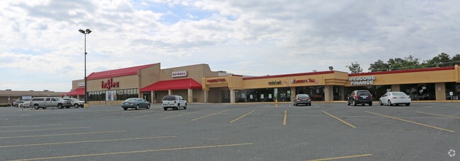
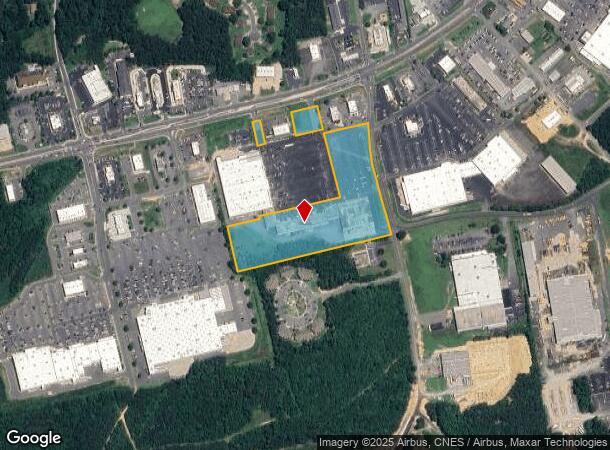
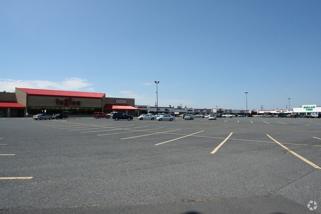
Property Record
Nc 24/27 Byp, Albemarle, NC 28001

NEARBY LISTINGS FOR SALE OR LEASE
Property Detail
Nc 24/27 Byp
6558-03-01-3487
BLDGS 636 NC 24/27 BYPASS 654820026
Supermarket
Stanly
X
North Carolina
3710655800J
10.53 AC
2025
Stanly County
2025
Charlotte
931203
Albemarle, NC
33,200 SF
DEMOGRAPHICS near Nc 24/27 Byp
1 Mile
3 Mile
5 Mile
2024 Total Population
3,185
16,647
25,010
2029 Population
3,456
18,070
27,042
Pop Growth 2024-2029
+ 8.51%
+ 8.55%
+ 8.12%
Average Age
41
41
42
2024 Total Households
1,290
6,989
10,151
HH Growth 2024-2029
+ 8.68%
+ 8.53%
+ 8.22%
Median Household Inc
$33,139
$42,812
$48,672
Avg Household Size
2.30
2.30
2.30
2024 Avg HH Vehicles
2.00
2.00
2.00
Median Home Value
$169,163
$156,357
$161,157
Median Year Built
1969
1965
1967
Nearby Places
Map Layers
Map Styles
 Street
 Aerial
- Restaurants
- Banks
- Shops
- Fitness
- Groceries
SALE & LEASE HISTORY
LISTING DATE
SALE/LEASE

May 10, 2017
For Lease
Dec 07, 2020
For Lease
Nearby Properties
Address
Land Use
TOTAL SIZE
Lot Size
Zoning
Address
Land Use
TOTAL SIZE
Lot Size
Zoning
232,921 SF
16.84 AC
MULTIPLE
Address
Land Use
TOTAL SIZE
Lot Size
Zoning
123,879 SF
24.13 AC
Address
Land Use
TOTAL SIZE
Lot Size
Zoning
70,906 SF
4.22 AC
CBD
Address
Land Use
TOTAL SIZE
Lot Size
Zoning
142,992 SF
13.23 AC
MULTIPLE
Address
Land Use
TOTAL SIZE
Lot Size
Zoning
187,271 SF
20.52 AC
GHBD
Address
Land Use
TOTAL SIZE
Lot Size
Zoning
114,360 SF
27.17 AC
R-10
Address
Land Use
TOTAL SIZE
Lot Size
Zoning
90,552 SF
25.76 AC
R-10
Address
Land Use
TOTAL SIZE
Lot Size
Zoning
87,267 SF
16.91 AC
MUSCD
Address
Land Use
TOTAL SIZE
Lot Size
Zoning
97,596 SF
6.07 AC
R-8A
Address
Land Use
TOTAL SIZE
Lot Size
Zoning
47,550 SF
2.89 AC
HMD
Address
Land Use
TOTAL SIZE
Lot Size
Zoning
151,681 SF
14.43 AC
GHBD
Address
Land Use
TOTAL SIZE
Lot Size
Zoning
277,547 SF
25 AC
HID
Address
Land Use
TOTAL SIZE
Lot Size
Zoning
41,184 SF
0.99 AC
CBD
Address
Land Use
TOTAL SIZE
Lot Size
Zoning
282.74 AC
MULTIPLE
Address
Land Use
TOTAL SIZE
Lot Size
Zoning
9,212 SF
27.04 AC
MULTIPLE
Address
Land Use
TOTAL SIZE
Lot Size
Zoning
140,459 SF
11.62 AC
MULTIPLE
Address
Land Use
TOTAL SIZE
Lot Size
Zoning
30,831 SF
2.32 AC
CBD
Address
Land Use
TOTAL SIZE
Lot Size
Zoning
104,384 SF
11.68 AC
MULTIPLE
Address
Land Use
TOTAL SIZE
Lot Size
Zoning
13,603 SF
6.37 AC
R-10
Address
Land Use
TOTAL SIZE
Lot Size
Zoning
20,008 SF
3 AC
NBD
Address
Land Use
TOTAL SIZE
Lot Size
Zoning
37,431 SF
10.56 AC
R-10
Address
Land Use
TOTAL SIZE
Lot Size
Zoning
92,896 SF
7.92 AC
GHBD
Address
Land Use
TOTAL SIZE
Lot Size
Zoning
57,086 SF
1.10 AC
RO
Address
Land Use
TOTAL SIZE
Lot Size
Zoning
19,826 SF
10.18 AC
MULTIPLE
Address
Land Use
TOTAL SIZE
Lot Size
Zoning
56,294 SF
8.80 AC
RO
Address
Land Use
TOTAL SIZE
Lot Size
Zoning
28,491 SF
4.94 AC
R-10
Address
Land Use
TOTAL SIZE
Lot Size
Zoning
31,461 SF
10.55 AC
R-8
Address
Land Use
TOTAL SIZE
Lot Size
Zoning
29,124 SF
2.45 AC
MULTIPLE
Address
Land Use
TOTAL SIZE
Lot Size
Zoning
9,105 SF
3.23 AC
GHBD
The World's #1 Commercial Real Estate Marketplace
Connect with us
© 2025 CoStar Group
The information above has been obtained from sources believed reliable. While we do not doubt its accuracy we have not verified it and make no guarantee, warranty or representation about it. It is your responsibility to independently confirm its accuracy and completeness. Any projections, opinions, assumptions, or estimates used are for example only and do not represent the current or future performance of the property. The value of this transaction to you depends on tax and other factors which should be evaluated by your tax, financial, and legal advisors. You and your advisors should conduct a careful, independent investigation of the property to determine to your satisfaction the suitability of the property for your needs.