Property Record
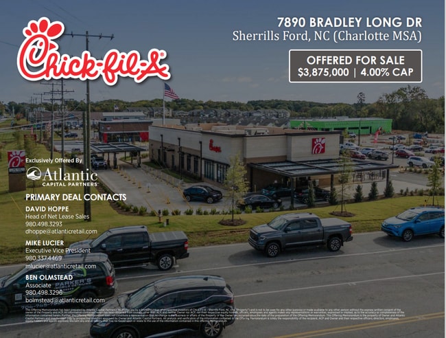
7890 Bradley Long Dr, Sherrills Ford, NC 28673
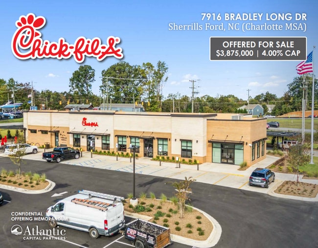


Property Detail
7890 Bradley Long Dr
Hickory-Lenoir-Morganton, NC
LOT 10 PLAT 82-145
4607168216580000
CATAWBA
Vacantlandnec
North Carolina
PD-CD
10
B and X Area of moderate flood hazard, usually the area between the limits of the 100-year and 500-year floods.
2.12 AC
2024
Catawba County
2025
Charlotte
011505
NEARBY LISTINGS FOR SALE OR LEASE
DEMOGRAPHICS near 7890 Bradley Long Dr
1 mile
3 mile
5 mile
2025 Total Population
2,531
11,032
34,587
2030 Population
2,749
11,962
37,694
Pop Growth 2025-2030
+ 8.61%
+ 8.43%
+ 8.98%
Average Age
47
46
44
2025 Total Households
1,075
4,546
13,416
HH Growth 2025-2030
+ 8.74%
+ 8.56%
+ 9.06%
Median Household Inc
$102,101
$101,879
$115,315
Avg Household Size
2.30
2.40
2.60
2025 Avg HH Vehicles
2.00
2.00
2.00
Median Home Value
$476,945
$527,811
$606,818
Median Year Built
2000
2000
2002
Nearby Places
Map Layers
Map Styles
 Street
 Aerial
Layers
 Traffic
 Biking
Places
Listings with unknown addresses are not visible on the map
- Restaurants
- Banks
- Shops
- Fitness
- Groceries
PUBLIC TRANSPORTATION
AIRPORT
Charlotte/Douglas International
Drive
Walk
Distance
Charlotte/Douglas International
51 min
31.4 mi
Concord-Padgett Regional
Drive
Walk
Distance
Concord-Padgett Regional
45 min
32.9 mi
Freight Ports
North Charleston Terminal
Drive
Walk
Distance
North Charleston Terminal
262 min
227.3 mi
SALE & LEASE HISTORY
LISTING DATE
SALE/LEASE

Oct 21, 2025
For Sale
Nearby Properties
Address
Land Use
TOTAL SIZE
Lot Size
Zoning
Address
Land Use
TOTAL SIZE
Lot Size
Zoning
31,198 SF
26.01 AC
PD-CD
Address
Land Use
TOTAL SIZE
Lot Size
Zoning
1,288 SF
16.04 AC
PD-CD
Address
Land Use
TOTAL SIZE
Lot Size
Zoning
1,709.40 AC
GI
Address
Land Use
TOTAL SIZE
Lot Size
Zoning
60,860 SF
9.81 AC
PD-CD
Address
Land Use
TOTAL SIZE
Lot Size
Zoning
79,137 SF
6.34 AC
HC
Address
Land Use
TOTAL SIZE
Lot Size
Zoning
80,181 SF
17.50 AC
R-20
Address
Land Use
TOTAL SIZE
Lot Size
Zoning
1,912 SF
31.99 AC
HC
Address
Land Use
TOTAL SIZE
Lot Size
Zoning
20,595 SF
2.65 AC
PD-CD
Address
Land Use
TOTAL SIZE
Lot Size
Zoning
1,850 SF
36.60 AC
PD
Address
Land Use
TOTAL SIZE
Lot Size
Zoning
33,342 SF
9.79 AC
RC
Address
Land Use
TOTAL SIZE
Lot Size
Zoning
1,500 SF
11.02 AC
PD
Address
Land Use
TOTAL SIZE
Lot Size
Zoning
2,000 SF
33.70 AC
R-30
Address
Land Use
TOTAL SIZE
Lot Size
Zoning
18,316 SF
3.61 AC
PD-CD
Address
Land Use
TOTAL SIZE
Lot Size
Zoning
37,999 SF
3.41 AC
HC
Address
Land Use
TOTAL SIZE
Lot Size
Zoning
6,889 SF
1.75 AC
PD-CD
Address
Land Use
TOTAL SIZE
Lot Size
Zoning
4,329 SF
1.43 AC
PD-CD
Address
Land Use
TOTAL SIZE
Lot Size
Zoning
12,352 SF
4.55 AC
HC
Address
Land Use
TOTAL SIZE
Lot Size
Zoning
5,290 SF
1.21 AC
PD-CD
Address
Land Use
TOTAL SIZE
Lot Size
Zoning
8.04 AC
R-20
Address
Land Use
TOTAL SIZE
Lot Size
Zoning
10,883 SF
2.50 AC
PD
Address
Land Use
TOTAL SIZE
Lot Size
Zoning
9,000 SF
6.04 AC
PD
Address
Land Use
TOTAL SIZE
Lot Size
Zoning
5,090 SF
1.01 AC
PD-CD
Address
Land Use
TOTAL SIZE
Lot Size
Zoning
13,876 SF
3.74 AC
R-30
Address
Land Use
TOTAL SIZE
Lot Size
Zoning
12,717 SF
1.47 AC
PD-CD
Address
Land Use
TOTAL SIZE
Lot Size
Zoning
5,307 SF
0.98 AC
R-30
Address
Land Use
TOTAL SIZE
Lot Size
Zoning
13.60 AC
PD-CD
Address
Land Use
TOTAL SIZE
Lot Size
Zoning
29,070 SF
5.36 AC
PD
Address
Land Use
TOTAL SIZE
Lot Size
Zoning
7,569 SF
1.53 AC
PD-CD
Address
Land Use
TOTAL SIZE
Lot Size
Zoning
19,692 SF
3.74 AC
PD
Address
Land Use
TOTAL SIZE
Lot Size
Zoning
79.78 AC
R-30
The World's #1 Commercial Real Estate Marketplace
Connect with us
© 2026 CoStar Group
The information above has been obtained from sources believed reliable. While we do not doubt its accuracy we have not verified it and make no guarantee, warranty or representation about it. It is your responsibility to independently confirm its accuracy and completeness. Any projections, opinions, assumptions, or estimates used are for example only and do not represent the current or future performance of the property. The value of this transaction to you depends on tax and other factors which should be evaluated by your tax, financial, and legal advisors. You and your advisors should conduct a careful, independent investigation of the property to determine to your satisfaction the suitability of the property for your needs.