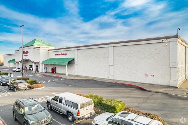
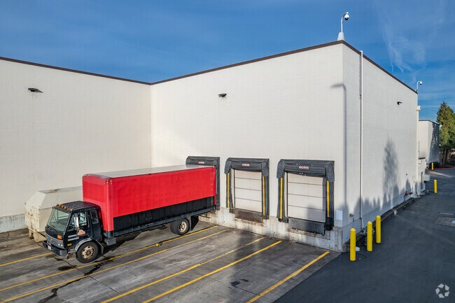
Property Record
905 Ne 136Th Ave, Vancouver, WA 98684

NEARBY LISTINGS FOR SALE OR LEASE
Property Detail
905 Ne 136Th Ave
Portland-Vancouver-Hillsboro, OR-WA
3-628
164739-000
LOT 1 SP3-628 12.57A FOR ASSESSOR USE ONLY LOT 1 SP3-628 12.57A
Supermarket
Clark
X
Washington
53011C0393D
1
2025
12.57 AC
2025
Cascade Park
041337
Portland
99,720 SF
DEMOGRAPHICS near 905 Ne 136Th Ave
1 Mile
3 Mile
5 Mile
2024 Total Population
16,938
125,114
240,573
2029 Population
18,366
135,075
259,961
Pop Growth 2024-2029
+ 8.43%
+ 7.96%
+ 8.06%
Average Age
39
40
39
2024 Total Households
6,603
48,297
90,451
HH Growth 2024-2029
+ 8.62%
+ 8.11%
+ 8.19%
Median Household Inc
$76,613
$77,624
$79,962
Avg Household Size
2.50
2.50
2.60
2024 Avg HH Vehicles
2.00
2.00
2.00
Median Home Value
$399,589
$399,959
$411,850
Median Year Built
1993
1992
1993
Nearby Places
Map Layers
Map Styles
 Street
 Aerial
- Restaurants
- Banks
- Shops
- Fitness
- Groceries
PUBLIC TRANSPORTATION
COMMUTER RAIL
DRIVE
WALK
Distance
20 min
9.9 mi
AIRPORT
Portland International
DRIVE
WALK
Distance
Portland International
17 min
8.7 mi
Freight Ports
Port of Vancouver
DRIVE
WALK
Distance
Port of Vancouver
23 min
12.5 mi
Nearby Properties
Address
Land Use
TOTAL SIZE
Lot Size
Zoning
Address
Land Use
TOTAL SIZE
Lot Size
Zoning
2,279,068 SF
137.78 AC
IL
Address
Land Use
TOTAL SIZE
Lot Size
Zoning
780,691 SF
17.66 AC
OCI
Address
Land Use
TOTAL SIZE
Lot Size
Zoning
681,799 SF
36.22 AC
IL
Address
Land Use
TOTAL SIZE
Lot Size
Zoning
399,563 SF
12.98 AC
CC
Address
Land Use
TOTAL SIZE
Lot Size
Zoning
304,876 SF
11.34 AC
R-18
Address
Land Use
TOTAL SIZE
Lot Size
Zoning
340,500 SF
19.01 AC
R-22
Address
Land Use
TOTAL SIZE
Lot Size
Zoning
264,044 SF
11.16 AC
CC
Address
Land Use
TOTAL SIZE
Lot Size
Zoning
339,894 SF
27.82 AC
R-22
Address
Land Use
TOTAL SIZE
Lot Size
Zoning
237,558 SF
15.48 AC
R-22
Address
Land Use
TOTAL SIZE
Lot Size
Zoning
341,504 SF
19.49 AC
R-22
Address
Land Use
TOTAL SIZE
Lot Size
Zoning
49,124 SF
17.26 AC
R-18
Address
Land Use
TOTAL SIZE
Lot Size
Zoning
233,766 SF
5.34 AC
R-30
Address
Land Use
TOTAL SIZE
Lot Size
Zoning
104,279 SF
6.09 AC
MX
Address
Land Use
TOTAL SIZE
Lot Size
Zoning
204,999 SF
5.71 AC
MX
Address
Land Use
TOTAL SIZE
Lot Size
Zoning
280,065 SF
14.80 AC
R-22
Address
Land Use
TOTAL SIZE
Lot Size
Zoning
253,976 SF
11.46 AC
MX
Address
Land Use
TOTAL SIZE
Lot Size
Zoning
285,765 SF
14.41 AC
R-22
Address
Land Use
TOTAL SIZE
Lot Size
Zoning
201,471 SF
8.76 AC
CG
Address
Land Use
TOTAL SIZE
Lot Size
Zoning
212,641 SF
8.03 AC
R-22
Address
Land Use
TOTAL SIZE
Lot Size
Zoning
171,584 SF
6.26 AC
MX
Address
Land Use
TOTAL SIZE
Lot Size
Zoning
244,812 SF
16.33 AC
CC
Address
Land Use
TOTAL SIZE
Lot Size
Zoning
177,297 SF
11.10 AC
R-18
Address
Land Use
TOTAL SIZE
Lot Size
Zoning
275,661 SF
15.23 AC
R-30
Address
Land Use
TOTAL SIZE
Lot Size
Zoning
301,864 SF
9.53 AC
R-22
Address
Land Use
TOTAL SIZE
Lot Size
Zoning
134,442 SF
6.35 AC
OCI
Address
Land Use
TOTAL SIZE
Lot Size
Zoning
188,974 SF
7.19 AC
R-30
Address
Land Use
TOTAL SIZE
Lot Size
Zoning
199,197 SF
10.60 AC
R-22
Address
Land Use
TOTAL SIZE
Lot Size
Zoning
273,844 SF
13.09 AC
R-22
Address
Land Use
TOTAL SIZE
Lot Size
Zoning
244,000 SF
14.38 AC
R-30
The World's #1 Commercial Real Estate Marketplace
Connect with us
© 2025 CoStar Group
The information above has been obtained from sources believed reliable. While we do not doubt its accuracy we have not verified it and make no guarantee, warranty or representation about it. It is your responsibility to independently confirm its accuracy and completeness. Any projections, opinions, assumptions, or estimates used are for example only and do not represent the current or future performance of the property. The value of this transaction to you depends on tax and other factors which should be evaluated by your tax, financial, and legal advisors. You and your advisors should conduct a careful, independent investigation of the property to determine to your satisfaction the suitability of the property for your needs.