Property Record
Public Owned, Lees Summit, MO 64082
NEARBY LISTINGS FOR SALE OR LEASE
Property Detail
Public Owned
70-500-03-07-01-2-00-000
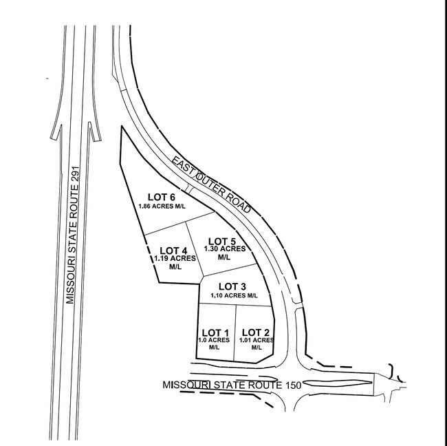
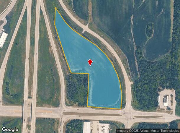
SEC-29 TWP-47 RNG-31 PT SW 1/4 DAF: BEG AT PT 570 MOL W & 1 15 MOL N OF SE COR SD SW 1/4 TH NLY 158 MOL TH NWLY 120 M OL TH NWLY 90 MOL TH NWLY 122 MOL TH NWLY 120 MOL TH NWLY
Agriculturalland
Jackson
X
Missouri
29095C0551G
7.50 AC
2024
Southeast Jackson County
2025
Kansas City
018101
Kansas City, MO-KS
DEMOGRAPHICS near Public Owned
1 Mile
3 Mile
5 Mile
2024 Total Population
4,523
24,593
66,006
2029 Population
4,530
24,989
66,244
Pop Growth 2024-2029
+ 0.15%
+ 1.61%
+ 0.36%
Average Age
40
39
39
2024 Total Households
1,566
8,732
24,542
HH Growth 2024-2029
+ 0.06%
+ 1.68%
+ 0.29%
Median Household Inc
$112,053
$121,490
$102,332
Avg Household Size
2.80
2.80
2.60
2024 Avg HH Vehicles
2.00
2.00
2.00
Median Home Value
$281,219
$320,427
$280,322
Median Year Built
1997
2000
1991
Nearby Places
- Restaurants
- Banks
- Shops
- Fitness
- Groceries
PUBLIC TRANSPORTATION
COMMUTER RAIL
Lee's Summit Amtrak (Lincoln Service Missouri River Runner - Amtrak, Missouri River Runner - Amtrak)
DRIVE
WALK
Distance
Lee's Summit Amtrak (Lincoln Service Missouri River Runner - Amtrak, Missouri River Runner - Amtrak)
8 min
4.6 mi
Freight Ports
Tulsa Port Of Catoosa
DRIVE
WALK
Distance
Tulsa Port Of Catoosa
254 min
233.5 mi
Nearby Properties
Address
Land Use
TOTAL SIZE
Lot Size
Zoning
Address
Land Use
TOTAL SIZE
Lot Size
Zoning
249,821 SF
87.90 AC
Address
Land Use
TOTAL SIZE
Lot Size
Zoning
563,000 SF
40.34 AC
Address
Land Use
TOTAL SIZE
Lot Size
Zoning
281,235 SF
70.15 AC
Address
Land Use
TOTAL SIZE
Lot Size
Zoning
200,526 SF
Address
Land Use
TOTAL SIZE
Lot Size
Zoning
18,509 SF
20.39 AC
Address
Land Use
TOTAL SIZE
Lot Size
Zoning
143,335 SF
Address
Land Use
TOTAL SIZE
Lot Size
Zoning
155,194 SF
21.03 AC
Address
Land Use
TOTAL SIZE
Lot Size
Zoning
36,744 SF
20.20 AC
Address
Land Use
TOTAL SIZE
Lot Size
Zoning
140,194 SF
29.50 AC
Address
Land Use
TOTAL SIZE
Lot Size
Zoning
65,290 SF
15.70 AC
Address
Land Use
TOTAL SIZE
Lot Size
Zoning
48,764 SF
8.25 AC
Address
Land Use
TOTAL SIZE
Lot Size
Zoning
74,741 SF
20 AC
Address
Land Use
TOTAL SIZE
Lot Size
Zoning
89,962 SF
10.37 AC
Address
Land Use
TOTAL SIZE
Lot Size
Zoning
171,779 SF
11.42 AC
Address
Land Use
TOTAL SIZE
Lot Size
Zoning
33,063 SF
17.56 AC
Address
Land Use
TOTAL SIZE
Lot Size
Zoning
Address
Land Use
TOTAL SIZE
Lot Size
Zoning
11,203 SF
1.27 AC
Address
Land Use
TOTAL SIZE
Lot Size
Zoning
Address
Land Use
TOTAL SIZE
Lot Size
Zoning
47,298 SF
11.67 AC
Address
Land Use
TOTAL SIZE
Lot Size
Zoning
225,792 SF
9.59 AC
Address
Land Use
TOTAL SIZE
Lot Size
Zoning
29,336 SF
Address
Land Use
TOTAL SIZE
Lot Size
Zoning
95,210 SF
21.28 AC
Address
Land Use
TOTAL SIZE
Lot Size
Zoning
61,263 SF
Address
Land Use
TOTAL SIZE
Lot Size
Zoning
34,840 SF
9.81 AC
Address
Land Use
TOTAL SIZE
Lot Size
Zoning
7,674 SF
Address
Land Use
TOTAL SIZE
Lot Size
Zoning
Address
Land Use
TOTAL SIZE
Lot Size
Zoning
24,567 SF
1.01 AC
Address
Land Use
TOTAL SIZE
Lot Size
Zoning
Address
Land Use
TOTAL SIZE
Lot Size
Zoning
19,632 SF
2.42 AC
Address
Land Use
TOTAL SIZE
Lot Size
Zoning
15,295 SF
The World's #1 Commercial Real Estate Marketplace
Connect with us
© 2025 CoStar Group
The information above has been obtained from sources believed reliable. While we do not doubt its accuracy we have not verified it and make no guarantee, warranty or representation about it. It is your responsibility to independently confirm its accuracy and completeness. Any projections, opinions, assumptions, or estimates used are for example only and do not represent the current or future performance of the property. The value of this transaction to you depends on tax and other factors which should be evaluated by your tax, financial, and legal advisors. You and your advisors should conduct a careful, independent investigation of the property to determine to your satisfaction the suitability of the property for your needs.