Property Record
2675 S 67Th Ave, Phoenix, AZ 85043

Current Lease Availabilities
NEARBY LISTINGS FOR SALE OR LEASE
Property Detail
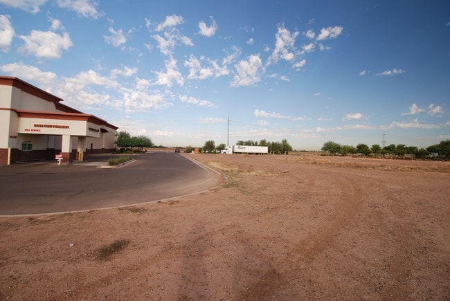
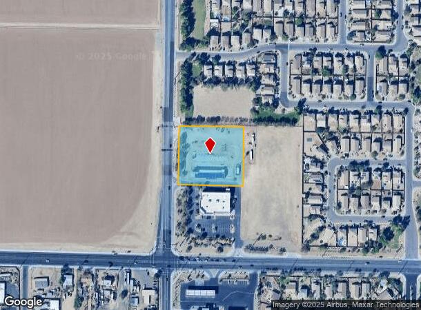
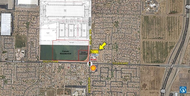
2675 S 67Th Ave
Phoenix-Mesa-Chandler, AZ
Northeast Corner Of Lower Buckeye Road &
104-37-635
NORTHEAST CORNER OF LOWER BUCKEYE ROAD & 67TH AVENUE MCR 828-27
Commercialacreage
Maricopa
X
Arizona
04013C2190M
3
2025
1.95 AC
2025
Southwest Phoenix
112516
Phoenix
5,600 SF
DEMOGRAPHICS near 2675 S 67Th Ave
1 mile
3 mile
5 mile
2024 Total Population
11,311
64,381
269,400
2029 Population
12,261
69,983
290,254
Pop Growth 2024-2029
+ 8.40%
+ 8.70%
+ 7.74%
Average Age
31
31
32
2024 Total Households
2,869
17,471
73,145
HH Growth 2024-2029
+ 8.47%
+ 8.96%
+ 7.86%
Median Household Inc
$59,711
$66,966
$61,206
Avg Household Size
3.80
3.50
3.50
2024 Avg HH Vehicles
2.00
2.00
2.00
Median Home Value
$271,776
$286,823
$267,297
Median Year Built
2004
2004
1995
Nearby Places
Map Layers
Map Styles
 Street
 Aerial
Transit
 Traffic
 Biking
Places
Listings with unknown addresses are not visible on the map
- Restaurants
- Banks
- Shops
- Fitness
- Groceries
PUBLIC TRANSPORTATION
AIRPORT
Phoenix Sky Harbor International
Drive
Walk
Distance
Phoenix Sky Harbor International
24 min
16.3 mi
Phoenix-Mesa Gateway
Drive
Walk
Distance
Phoenix-Mesa Gateway
51 min
39.4 mi
Nearby Properties
Address
Land Use
TOTAL SIZE
Lot Size
Zoning
Address
Land Use
TOTAL SIZE
Lot Size
Zoning
569,517 SF
33.38 AC
PUD
Address
Land Use
TOTAL SIZE
Lot Size
Zoning
68,452 SF
37.95 AC
R-35
Address
Land Use
TOTAL SIZE
Lot Size
Zoning
60.41 AC
CPGCP
Address
Land Use
TOTAL SIZE
Lot Size
Zoning
86,350 SF
25.82 AC
I-1
Address
Land Use
TOTAL SIZE
Lot Size
Zoning
1,539,348 SF
143.97 AC
A-1
Address
Land Use
TOTAL SIZE
Lot Size
Zoning
61,508 SF
23.76 AC
I-1
Address
Land Use
TOTAL SIZE
Lot Size
Zoning
1,377,683 SF
72.08 AC
I-1
Address
Land Use
TOTAL SIZE
Lot Size
Zoning
899,427 SF
73.79 AC
R1-6
Address
Land Use
TOTAL SIZE
Lot Size
Zoning
1,267,497 SF
70.43 AC
A1
Address
Land Use
TOTAL SIZE
Lot Size
Zoning
1,205,743 SF
59.34 AC
I-1
Address
Land Use
TOTAL SIZE
Lot Size
Zoning
1,100,500 SF
57.61 AC
PUD
Address
Land Use
TOTAL SIZE
Lot Size
Zoning
1,063,188 SF
59.94 AC
Address
Land Use
TOTAL SIZE
Lot Size
Zoning
270,483 SF
53.58 AC
R-43AG
Address
Land Use
TOTAL SIZE
Lot Size
Zoning
4,900 SF
12.05 AC
R1-6
Address
Land Use
TOTAL SIZE
Lot Size
Zoning
554,581 SF
37.82 AC
A1
Address
Land Use
TOTAL SIZE
Lot Size
Zoning
375,848 SF
117.15 AC
A1
Address
Land Use
TOTAL SIZE
Lot Size
Zoning
1,009,390 SF
44.22 AC
A1
Address
Land Use
TOTAL SIZE
Lot Size
Zoning
697,149 SF
37.60 AC
CP/GCP
Address
Land Use
TOTAL SIZE
Lot Size
Zoning
750,037 SF
49.40 AC
I1
Address
Land Use
TOTAL SIZE
Lot Size
Zoning
659,834 SF
42.04 AC
R-6
Address
Land Use
TOTAL SIZE
Lot Size
Zoning
351,903 SF
29.13 AC
A1
Address
Land Use
TOTAL SIZE
Lot Size
Zoning
436,817 SF
23.21 AC
I-P
Address
Land Use
TOTAL SIZE
Lot Size
Zoning
580,382 SF
31.77 AC
PAD
Address
Land Use
TOTAL SIZE
Lot Size
Zoning
682,727 SF
37.38 AC
I-1
Address
Land Use
TOTAL SIZE
Lot Size
Zoning
569,792 SF
32.25 AC
I-1
Address
Land Use
TOTAL SIZE
Lot Size
Zoning
592,330 SF
36.89 AC
I-2
Address
Land Use
TOTAL SIZE
Lot Size
Zoning
684,420 SF
38.13 AC
I-1
Address
Land Use
TOTAL SIZE
Lot Size
Zoning
662,796 SF
42.11 AC
I-1
Address
Land Use
TOTAL SIZE
Lot Size
Zoning
169,155 SF
32.84 AC
R-35
Address
Land Use
TOTAL SIZE
Lot Size
Zoning
532,713 SF
27.31 AC
The World's #1 Commercial Real Estate Marketplace
Connect with us
© 2026 CoStar Group
The information above has been obtained from sources believed reliable. While we do not doubt its accuracy we have not verified it and make no guarantee, warranty or representation about it. It is your responsibility to independently confirm its accuracy and completeness. Any projections, opinions, assumptions, or estimates used are for example only and do not represent the current or future performance of the property. The value of this transaction to you depends on tax and other factors which should be evaluated by your tax, financial, and legal advisors. You and your advisors should conduct a careful, independent investigation of the property to determine to your satisfaction the suitability of the property for your needs.