Property Record
119 Main St E, Northfield, MN 55057


This Property Is For Sale
Property Detail
119 Main St E
Faribault-Northfield, MN
NW4 SE4 EX 1-35
02.25.4.25.001
RICE
Agriculturalland
Minnesota
B and X Area of moderate flood hazard, usually the area between the limits of the 100-year and 500-year floods.
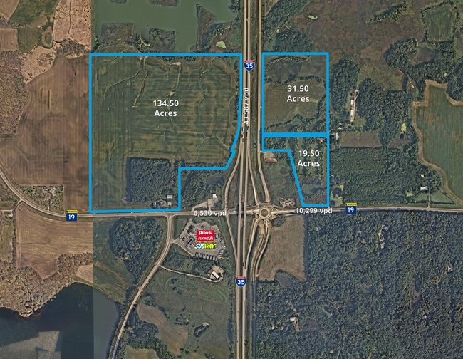
31.50 AC
2026
Minnesota South Area
2026
Other Market Areas
070601
NEARBY LISTINGS FOR SALE OR LEASE
-
-
View all Northfield listings for sale on LoopNet.com
DEMOGRAPHICS near 119 Main St E
1 mile
3 mile
5 mile
2025 Total Population
145
1,158
4,039
2030 Population
150
1,189
4,148
Pop Growth 2025-2030
+ 3.45%
+ 2.68%
+ 2.70%
Average Age
41
41
42
2025 Total Households
52
413
1,459
HH Growth 2025-2030
+ 1.92%
+ 2.91%
+ 2.95%
Median Household Inc
$110,937
$110,145
$108,776
Avg Household Size
2.80
2.80
2.70
2025 Avg HH Vehicles
3.00
3.00
3.00
Median Home Value
$420,000
$437,647
$427,104
Median Year Built
1992
1991
1992
Nearby Places
Map Layers
Map Styles
 Street
 Aerial
Layers
 Traffic
 Biking
Places
Listings with unknown addresses are not visible on the map
- Restaurants
- Banks
- Shops
- Fitness
- Groceries
PUBLIC TRANSPORTATION
AIRPORT
Minneapolis-St Paul International/Wold-Chamberlain
Drive
Walk
Distance
Minneapolis-St Paul International/Wold-Chamberlain
40 min
32.9 mi
Freight Ports
Port Milwaukee
Drive
Walk
Distance
Port Milwaukee
383 min
338.1 mi
Nearby Properties
Address
Land Use
TOTAL SIZE
Lot Size
Zoning
Address
Land Use
TOTAL SIZE
Lot Size
Zoning
3,366 SF
10.20 AC
Address
Land Use
TOTAL SIZE
Lot Size
Zoning
3,520 SF
213.79 AC
Address
Land Use
TOTAL SIZE
Lot Size
Zoning
2,735 SF
54 AC
Address
Land Use
TOTAL SIZE
Lot Size
Zoning
120.19 AC
Address
Land Use
TOTAL SIZE
Lot Size
Zoning
2,872 SF
70.53 AC
Address
Land Use
TOTAL SIZE
Lot Size
Zoning
4,038 SF
38.30 AC
Address
Land Use
TOTAL SIZE
Lot Size
Zoning
4,456 SF
37.86 AC
Address
Land Use
TOTAL SIZE
Lot Size
Zoning
6,884 SF
3.86 AC
Address
Land Use
TOTAL SIZE
Lot Size
Zoning
2,413 SF
17.50 AC
Address
Land Use
TOTAL SIZE
Lot Size
Zoning
1,138 SF
75.96 AC
Address
Land Use
TOTAL SIZE
Lot Size
Zoning
31.10 AC
Address
Land Use
TOTAL SIZE
Lot Size
Zoning
1,521 SF
4.60 AC
Address
Land Use
TOTAL SIZE
Lot Size
Zoning
3,572 SF
16.50 AC
Address
Land Use
TOTAL SIZE
Lot Size
Zoning
5,832 SF
68.30 AC
Address
Land Use
TOTAL SIZE
Lot Size
Zoning
62.54 AC
Address
Land Use
TOTAL SIZE
Lot Size
Zoning
2,858 SF
6.19 AC
Address
Land Use
TOTAL SIZE
Lot Size
Zoning
7,200 SF
13.16 AC
Address
Land Use
TOTAL SIZE
Lot Size
Zoning
900 SF
3.50 AC
Address
Land Use
TOTAL SIZE
Lot Size
Zoning
Address
Land Use
TOTAL SIZE
Lot Size
Zoning
3,150 SF
3 AC
Address
Land Use
TOTAL SIZE
Lot Size
Zoning
2,550 SF
14.34 AC
Address
Land Use
TOTAL SIZE
Lot Size
Zoning
65.50 AC
Address
Land Use
TOTAL SIZE
Lot Size
Zoning
70.07 AC
Address
Land Use
TOTAL SIZE
Lot Size
Zoning
8,816 SF
5.52 AC
Address
Land Use
TOTAL SIZE
Lot Size
Zoning
39.47 AC
Address
Land Use
TOTAL SIZE
Lot Size
Zoning
36.03 AC
Address
Land Use
TOTAL SIZE
Lot Size
Zoning
The World's #1 Commercial Real Estate Marketplace
Connect with us
© 2026 CoStar Group
The information above has been obtained from sources believed reliable. While we do not doubt its accuracy we have not verified it and make no guarantee, warranty or representation about it. It is your responsibility to independently confirm its accuracy and completeness. Any projections, opinions, assumptions, or estimates used are for example only and do not represent the current or future performance of the property. The value of this transaction to you depends on tax and other factors which should be evaluated by your tax, financial, and legal advisors. You and your advisors should conduct a careful, independent investigation of the property to determine to your satisfaction the suitability of the property for your needs.