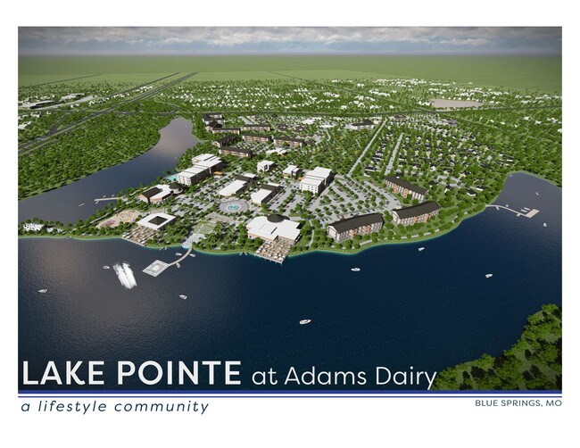
Property Record
1400 Ne Adams Dairy Rd, Blue Springs, MO 64014

NEARBY LISTINGS FOR SALE OR LEASE
-
-
-
-
-
-
-
No Photo
-
View all Blue Springs listings for sale on LoopNet.com
Property Detail
1400 Ne Adams Dairy Rd
36-500-01-05-01-1-00-000
EC-29 TWP-49 RNG-30 --- PT NE 1/4 DAF: BEG SE COR TH NLY 169 TO TRU POB TH SWLY 207 MOL TH WLY 541 MOL TH NLY 220 MO L TH ELY 336 MOL TH SLY 189 MOL TH NWLY 482.7 TH SWLY 133
Agriculturalland
Jackson
AE
Missouri
29095C0336G
17 AC
2024
East Jackson County
2025
Kansas City
014905
Kansas City, MO-KS
DEMOGRAPHICS near 1400 Ne Adams Dairy Rd
1 Mile
3 Mile
5 Mile
2024 Total Population
5,047
46,096
77,333
2029 Population
4,957
45,618
76,577
Pop Growth 2024-2029
(1.78%)
(1.04%)
(0.98%)
Average Age
40
38
38
2024 Total Households
1,782
17,105
28,313
HH Growth 2024-2029
(1.96%)
(1.14%)
(1.11%)
Median Household Inc
$102,500
$79,839
$85,217
Avg Household Size
2.80
2.60
2.70
2024 Avg HH Vehicles
2.00
2.00
2.00
Median Home Value
$266,965
$228,986
$237,864
Median Year Built
1990
1988
1989
Nearby Places
Map Layers
Map Styles
 Street
 Aerial
- Restaurants
- Banks
- Shops
- Fitness
- Groceries
SALE & LEASE HISTORY
LISTING DATE
SALE/LEASE

Jul 31, 2018
For Sale
Nearby Properties
Address
Land Use
TOTAL SIZE
Lot Size
Zoning
Address
Land Use
TOTAL SIZE
Lot Size
Zoning
292,760 SF
32.17 AC
Address
Land Use
TOTAL SIZE
Lot Size
Zoning
448,225 SF
38.38 AC
Address
Land Use
TOTAL SIZE
Lot Size
Zoning
228,168 SF
25.12 AC
Address
Land Use
TOTAL SIZE
Lot Size
Zoning
584,820 SF
38 AC
Address
Land Use
TOTAL SIZE
Lot Size
Zoning
255,288 SF
25.67 AC
Address
Land Use
TOTAL SIZE
Lot Size
Zoning
28,639 SF
10.40 AC
Address
Land Use
TOTAL SIZE
Lot Size
Zoning
321,331 SF
55.69 AC
Address
Land Use
TOTAL SIZE
Lot Size
Zoning
127,621 SF
23 AC
Address
Land Use
TOTAL SIZE
Lot Size
Zoning
214,518 SF
22.16 AC
Address
Land Use
TOTAL SIZE
Lot Size
Zoning
430,717 SF
69.75 AC
Address
Land Use
TOTAL SIZE
Lot Size
Zoning
48,440 SF
21.49 AC
Address
Land Use
TOTAL SIZE
Lot Size
Zoning
71,169 SF
0.82 AC
Address
Land Use
TOTAL SIZE
Lot Size
Zoning
74,031 SF
0.02 AC
Address
Land Use
TOTAL SIZE
Lot Size
Zoning
96,371 SF
10.55 AC
Address
Land Use
TOTAL SIZE
Lot Size
Zoning
98,523 SF
9.48 AC
Address
Land Use
TOTAL SIZE
Lot Size
Zoning
42,176 SF
22.04 AC
Address
Land Use
TOTAL SIZE
Lot Size
Zoning
36,952 SF
20.90 AC
Address
Land Use
TOTAL SIZE
Lot Size
Zoning
93,336 SF
11.67 AC
Address
Land Use
TOTAL SIZE
Lot Size
Zoning
80,458 SF
0.40 AC
Address
Land Use
TOTAL SIZE
Lot Size
Zoning
48,270 SF
4.61 AC
Address
Land Use
TOTAL SIZE
Lot Size
Zoning
82,602 SF
8.80 AC
Address
Land Use
TOTAL SIZE
Lot Size
Zoning
49,601 SF
8.03 AC
Address
Land Use
TOTAL SIZE
Lot Size
Zoning
98,600 SF
4.50 AC
Address
Land Use
TOTAL SIZE
Lot Size
Zoning
130,178 SF
10.25 AC
Address
Land Use
TOTAL SIZE
Lot Size
Zoning
67,986 SF
9.88 AC
Address
Land Use
TOTAL SIZE
Lot Size
Zoning
75,977 SF
8.86 AC
Address
Land Use
TOTAL SIZE
Lot Size
Zoning
36,000 SF
5.22 AC
Address
Land Use
TOTAL SIZE
Lot Size
Zoning
61,567 SF
10 AC
Address
Land Use
TOTAL SIZE
Lot Size
Zoning
80,774 SF
Address
Land Use
TOTAL SIZE
Lot Size
Zoning
110,829 SF
20.78 AC
The World's #1 Commercial Real Estate Marketplace
Connect with us
© 2025 CoStar Group
The information above has been obtained from sources believed reliable. While we do not doubt its accuracy we have not verified it and make no guarantee, warranty or representation about it. It is your responsibility to independently confirm its accuracy and completeness. Any projections, opinions, assumptions, or estimates used are for example only and do not represent the current or future performance of the property. The value of this transaction to you depends on tax and other factors which should be evaluated by your tax, financial, and legal advisors. You and your advisors should conduct a careful, independent investigation of the property to determine to your satisfaction the suitability of the property for your needs.