Property Record
Ne Seward Ave, Topeka, KS 66616
NEARBY LISTINGS FOR SALE OR LEASE
Property Detail
Ne Seward Ave
Topeka, KS
Champney Industrial Sub
107-26-0-40-01-003-000
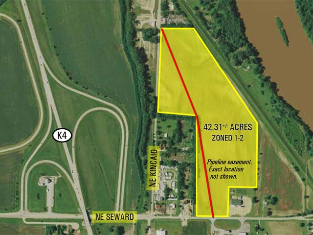
S26, T11, R16, ACRES 42.31, BEG 160 S & 33 E OF NW COR SE 1/4 TH E 380(S) SE 420(S) NE 20(S) SE 155(S) SW 50(S) SE 100(S) NE 50 (S) SELY 800(S) S 950(S) W 338.29
Agriculturalland
Shawnee
A
Kansas
20177C0236E
9
2024
42.31 AC
2025
Topeka
001000
Kansas City
DEMOGRAPHICS near Ne Seward Ave
1 Mile
3 Mile
5 Mile
2024 Total Population
175
14,680
54,297
2029 Population
174
14,599
54,267
Pop Growth 2024-2029
(0.57%)
(0.55%)
(0.06%)
Average Age
42
39
39
2024 Total Households
72
5,424
21,347
HH Growth 2024-2029
0.00%
(0.65%)
+ 0.02%
Median Household Inc
$56,666
$46,972
$44,739
Avg Household Size
2.30
2.40
2.40
2024 Avg HH Vehicles
2.00
2.00
2.00
Median Home Value
$94,827
$91,626
$102,881
Median Year Built
1955
1957
1962
Nearby Places
Map Layers
Map Styles
 Street
 Aerial
- Restaurants
- Banks
- Shops
- Fitness
- Groceries
PUBLIC TRANSPORTATION
COMMUTER RAIL
Topeka Amtrak Station (Southwest Chief - Amtrak)
DRIVE
WALK
Distance
Topeka Amtrak Station (Southwest Chief - Amtrak)
5 min
2.2 mi
Freight Ports
Tulsa Port Of Catoosa
DRIVE
WALK
Distance
Tulsa Port Of Catoosa
281 min
236.0 mi
Nearby Properties
Address
Land Use
TOTAL SIZE
Lot Size
Zoning
Address
Land Use
TOTAL SIZE
Lot Size
Zoning
52,453 SF
17.12 AC
C5,OI2
Address
Land Use
TOTAL SIZE
Lot Size
Zoning
64,058 SF
3.31 AC
C4,OI2
Address
Land Use
TOTAL SIZE
Lot Size
Zoning
3.31 AC
OI2
Address
Land Use
TOTAL SIZE
Lot Size
Zoning
285,005 SF
3.10 AC
C4,C5,I1
Address
Land Use
TOTAL SIZE
Lot Size
Zoning
65,687 SF
7.47 AC
C2,I1,M2
Address
Land Use
TOTAL SIZE
Lot Size
Zoning
137,637 SF
10.43 AC
M2
Address
Land Use
TOTAL SIZE
Lot Size
Zoning
98,898 SF
1.91 AC
C5
Address
Land Use
TOTAL SIZE
Lot Size
Zoning
107,592 SF
14.98 AC
C4,I1,OI2
Address
Land Use
TOTAL SIZE
Lot Size
Zoning
181,781 SF
569.17 AC
R1
Address
Land Use
TOTAL SIZE
Lot Size
Zoning
127,947 SF
7.12 AC
C5
Address
Land Use
TOTAL SIZE
Lot Size
Zoning
54,654 SF
0.56 AC
C5
Address
Land Use
TOTAL SIZE
Lot Size
Zoning
112,413 SF
0.73 AC
C5
Address
Land Use
TOTAL SIZE
Lot Size
Zoning
101,766 SF
2.39 AC
C5,I1
Address
Land Use
TOTAL SIZE
Lot Size
Zoning
101,166 SF
3.31 AC
C5
Address
Land Use
TOTAL SIZE
Lot Size
Zoning
161,335 SF
37.32 AC
R1
Address
Land Use
TOTAL SIZE
Lot Size
Zoning
32,838 SF
3.25 AC
MS1
Address
Land Use
TOTAL SIZE
Lot Size
Zoning
92,118 SF
10.87 AC
R2
Address
Land Use
TOTAL SIZE
Lot Size
Zoning
61,680 SF
2.20 AC
C5
Address
Land Use
TOTAL SIZE
Lot Size
Zoning
188,606 SF
8.42 AC
I1
Address
Land Use
TOTAL SIZE
Lot Size
Zoning
51,514 SF
1.87 AC
I2
Address
Land Use
TOTAL SIZE
Lot Size
Zoning
15,927 SF
1.44 AC
C4
Address
Land Use
TOTAL SIZE
Lot Size
Zoning
70,058 SF
1.03 AC
C5
Address
Land Use
TOTAL SIZE
Lot Size
Zoning
75,691 SF
5.91 AC
M1,M2
Address
Land Use
TOTAL SIZE
Lot Size
Zoning
25,758 SF
1.64 AC
M2
Address
Land Use
TOTAL SIZE
Lot Size
Zoning
21,978 SF
2.79 AC
C2,M4
Address
Land Use
TOTAL SIZE
Lot Size
Zoning
26,269 SF
8.18 AC
RR1
Address
Land Use
TOTAL SIZE
Lot Size
Zoning
14,216 SF
0.78 AC
Address
Land Use
TOTAL SIZE
Lot Size
Zoning
88,401 SF
1.51 AC
C5
Address
Land Use
TOTAL SIZE
Lot Size
Zoning
18,984 SF
0.35 AC
HL,X3
Address
Land Use
TOTAL SIZE
Lot Size
Zoning
47,037 SF
8 AC
R2
The World's #1 Commercial Real Estate Marketplace
Connect with us
© 2025 CoStar Group
The information above has been obtained from sources believed reliable. While we do not doubt its accuracy we have not verified it and make no guarantee, warranty or representation about it. It is your responsibility to independently confirm its accuracy and completeness. Any projections, opinions, assumptions, or estimates used are for example only and do not represent the current or future performance of the property. The value of this transaction to you depends on tax and other factors which should be evaluated by your tax, financial, and legal advisors. You and your advisors should conduct a careful, independent investigation of the property to determine to your satisfaction the suitability of the property for your needs.