Property Record
Near Intracoastal Canal, Aransas Pass, TX 78336

Property Detail
Near Intracoastal Canal
Corpus Christi, TX
A201 ELIZABETH TALLEY SURVEY, ACRES 21.31, (ADD'N IMPS)
R57126
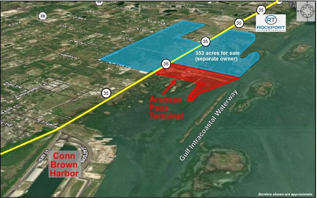
ARANSAS
Residentialacreage
Texas
AE The base floodplain where base flood elevations are provided. AE Zones are now used on new format FIRMs instead of A1-A30 Zones.
16 AC
2025
Rockport/N Aransas
2025
Corpus Christi
010202
NEARBY LISTINGS FOR SALE OR LEASE
DEMOGRAPHICS near Near Intracoastal Canal
1 mile
3 mile
5 mile
2025 Total Population
639
10,498
15,936
2030 Population
674
11,082
16,762
Pop Growth 2025-2030
+ 5.48%
+ 5.56%
+ 5.18%
Average Age
43
44
43
2025 Total Households
249
4,253
6,376
HH Growth 2025-2030
+ 5.62%
+ 5.81%
+ 5.33%
Median Household Inc
$61,356
$55,387
$58,248
Avg Household Size
2.60
2.40
2.40
2025 Avg HH Vehicles
1.00
2.00
2.00
Median Home Value
$240,909
$199,934
$208,886
Median Year Built
1999
1995
1994
Nearby Places
Map Layers
Map Styles
 Street
 Aerial
Layers
 Traffic
 Biking
Places
Listings with unknown addresses are not visible on the map
- Restaurants
- Banks
- Shops
- Fitness
- Groceries
PUBLIC TRANSPORTATION
AIRPORT
Corpus Christi International
Drive
Walk
Distance
Corpus Christi International
44 min
31.2 mi
Freight Ports
Port of Corpus Christi
Drive
Walk
Distance
Port of Corpus Christi
31 min
23.2 mi
SALE & LEASE HISTORY
LISTING DATE
SALE/LEASE

Sep 30, 2024
For Sale
Aug 16, 2022
For Sale
Nearby Properties
Address
Land Use
TOTAL SIZE
Lot Size
Zoning
Address
Land Use
TOTAL SIZE
Lot Size
Zoning
39,253 SF
54.77 AC
Address
Land Use
TOTAL SIZE
Lot Size
Zoning
61,410 SF
7.86 AC
Address
Land Use
TOTAL SIZE
Lot Size
Zoning
43,294 SF
8.56 AC
Address
Land Use
TOTAL SIZE
Lot Size
Zoning
36,324 SF
8.89 AC
Address
Land Use
TOTAL SIZE
Lot Size
Zoning
58,474 SF
2.60 AC
Address
Land Use
TOTAL SIZE
Lot Size
Zoning
51,488 SF
2.75 AC
Address
Land Use
TOTAL SIZE
Lot Size
Zoning
46,364 SF
3.18 AC
Address
Land Use
TOTAL SIZE
Lot Size
Zoning
42,328 SF
3.25 AC
Address
Land Use
TOTAL SIZE
Lot Size
Zoning
165,600 SF
12.32 AC
Address
Land Use
TOTAL SIZE
Lot Size
Zoning
19,710 SF
4.70 AC
Address
Land Use
TOTAL SIZE
Lot Size
Zoning
27,557 SF
12.34 AC
Address
Land Use
TOTAL SIZE
Lot Size
Zoning
94,505 SF
4.20 AC
Address
Land Use
TOTAL SIZE
Lot Size
Zoning
39,734 SF
2.20 AC
Address
Land Use
TOTAL SIZE
Lot Size
Zoning
22,774 SF
1.51 AC
Address
Land Use
TOTAL SIZE
Lot Size
Zoning
Address
Land Use
TOTAL SIZE
Lot Size
Zoning
7,525 SF
15.81 AC
Address
Land Use
TOTAL SIZE
Lot Size
Zoning
63,396 SF
4 AC
Address
Land Use
TOTAL SIZE
Lot Size
Zoning
4,046 SF
7.15 AC
Address
Land Use
TOTAL SIZE
Lot Size
Zoning
20,460 SF
3.97 AC
Address
Land Use
TOTAL SIZE
Lot Size
Zoning
10,235 SF
34.85 AC
Address
Land Use
TOTAL SIZE
Lot Size
Zoning
22,536 SF
0.09 AC
Address
Land Use
TOTAL SIZE
Lot Size
Zoning
6,188 SF
20.10 AC
Address
Land Use
TOTAL SIZE
Lot Size
Zoning
32,791 SF
4.86 AC
Address
Land Use
TOTAL SIZE
Lot Size
Zoning
5,253 SF
7.72 AC
Address
Land Use
TOTAL SIZE
Lot Size
Zoning
24,063 SF
1.75 AC
Address
Land Use
TOTAL SIZE
Lot Size
Zoning
19,309 SF
0.64 AC
Address
Land Use
TOTAL SIZE
Lot Size
Zoning
1,986 SF
5 AC
Address
Land Use
TOTAL SIZE
Lot Size
Zoning
63,334 SF
0.89 AC
Address
Land Use
TOTAL SIZE
Lot Size
Zoning
48,360 SF
5.40 AC
Address
Land Use
TOTAL SIZE
Lot Size
Zoning
3,634 SF
9.89 AC
The World's #1 Commercial Real Estate Marketplace
Connect with us
© 2026 CoStar Group
The information above has been obtained from sources believed reliable. While we do not doubt its accuracy we have not verified it and make no guarantee, warranty or representation about it. It is your responsibility to independently confirm its accuracy and completeness. Any projections, opinions, assumptions, or estimates used are for example only and do not represent the current or future performance of the property. The value of this transaction to you depends on tax and other factors which should be evaluated by your tax, financial, and legal advisors. You and your advisors should conduct a careful, independent investigation of the property to determine to your satisfaction the suitability of the property for your needs.