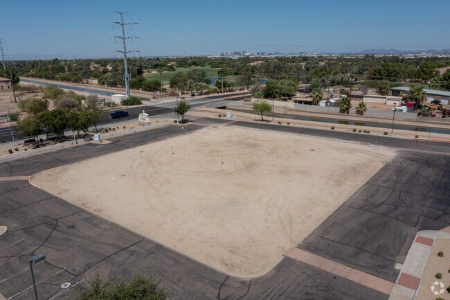
Property Record
3210 E Baseline Rd, Phoenix, AZ 85042

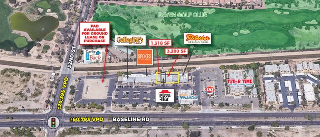
Current Lease Availabilities
Property Detail
3210 E Baseline Rd
Phoenix-Mesa-Chandler, AZ
RAVENS MCR 714-19
122-97-239
MARICOPA
Commercialnec
Arizona
C-N
1
A Areas with a 1% annual chance of flooding and a 26% chance of flooding over the life of a 30-year mortgage.
1.75 AC
2025
South Mountain
2025
Phoenix
116300
NEARBY LISTINGS FOR SALE OR LEASE
DEMOGRAPHICS near 3210 E Baseline Rd
1 mile
3 mile
5 mile
2025 Total Population
8,322
83,326
232,906
2030 Population
8,699
86,260
241,283
Pop Growth 2025-2030
+ 4.53%
+ 3.52%
+ 3.60%
Average Age
38
37
37
2025 Total Households
3,316
29,536
85,899
HH Growth 2025-2030
+ 4.64%
+ 3.59%
+ 3.59%
Median Household Inc
$99,652
$81,966
$77,760
Avg Household Size
2.50
2.70
2.60
2025 Avg HH Vehicles
2.00
2.00
2.00
Median Home Value
$592,832
$391,031
$420,849
Median Year Built
2001
1986
1986
Nearby Places
Map Layers
Map Styles
 Street
 Aerial
Layers
 Traffic
 Biking
Places
Listings with unknown addresses are not visible on the map
- Restaurants
- Banks
- Shops
- Fitness
- Groceries
PUBLIC TRANSPORTATION
AIRPORT
Phoenix Sky Harbor International
Drive
Walk
Distance
Phoenix Sky Harbor International
14 min
6.9 mi
Phoenix-Mesa Gateway
Drive
Walk
Distance
Phoenix-Mesa Gateway
39 min
27.1 mi
Nearby Properties
Address
Land Use
TOTAL SIZE
Lot Size
Zoning
Address
Land Use
TOTAL SIZE
Lot Size
Zoning
12.93 AC
I-P
Address
Land Use
TOTAL SIZE
Lot Size
Zoning
81,816 SF
7.95 AC
Address
Land Use
TOTAL SIZE
Lot Size
Zoning
94,162 SF
9.40 AC
I-2
Address
Land Use
TOTAL SIZE
Lot Size
Zoning
1,479,006 SF
84.96 AC
C-R
Address
Land Use
TOTAL SIZE
Lot Size
Zoning
10,776 SF
10.14 AC
C-C
Address
Land Use
TOTAL SIZE
Lot Size
Zoning
331,050 SF
39 AC
I-1
Address
Land Use
TOTAL SIZE
Lot Size
Zoning
32,968 SF
2.10 AC
I-P
Address
Land Use
TOTAL SIZE
Lot Size
Zoning
359,401 SF
96.70 AC
R-6
Address
Land Use
TOTAL SIZE
Lot Size
Zoning
180,690 SF
11.20 AC
I-P
Address
Land Use
TOTAL SIZE
Lot Size
Zoning
586,083 SF
69.82 AC
Address
Land Use
TOTAL SIZE
Lot Size
Zoning
309.82 AC
R-35
Address
Land Use
TOTAL SIZE
Lot Size
Zoning
301,102 SF
27.45 AC
Address
Land Use
TOTAL SIZE
Lot Size
Zoning
734,975 SF
10.53 AC
Address
Land Use
TOTAL SIZE
Lot Size
Zoning
442,003 SF
24.85 AC
M-H
Address
Land Use
TOTAL SIZE
Lot Size
Zoning
320,708 SF
16.25 AC
A1
Address
Land Use
TOTAL SIZE
Lot Size
Zoning
353,363 SF
21.29 AC
A-1
Address
Land Use
TOTAL SIZE
Lot Size
Zoning
112,968 SF
10.55 AC
R-43AG
Address
Land Use
TOTAL SIZE
Lot Size
Zoning
283,648 SF
6.83 AC
Address
Land Use
TOTAL SIZE
Lot Size
Zoning
3.59 AC
Address
Land Use
TOTAL SIZE
Lot Size
Zoning
214,325 SF
12.09 AC
A1
Address
Land Use
TOTAL SIZE
Lot Size
Zoning
391,186 SF
16.44 AC
M-H
Address
Land Use
TOTAL SIZE
Lot Size
Zoning
278,400 SF
10.17 AC
R-6
Address
Land Use
TOTAL SIZE
Lot Size
Zoning
356,904 SF
18.74 AC
GID
Address
Land Use
TOTAL SIZE
Lot Size
Zoning
220,379 SF
16.87 AC
Address
Land Use
TOTAL SIZE
Lot Size
Zoning
308,180 SF
18.77 AC
I-P
Address
Land Use
TOTAL SIZE
Lot Size
Zoning
155,440 SF
6.35 AC
A2
Address
Land Use
TOTAL SIZE
Lot Size
Zoning
261.15 AC
RE-35
Address
Land Use
TOTAL SIZE
Lot Size
Zoning
225,031 SF
17.80 AC
I-P
Address
Land Use
TOTAL SIZE
Lot Size
Zoning
477,320 SF
26.58 AC
I-P
Address
Land Use
TOTAL SIZE
Lot Size
Zoning
172,272 SF
5.74 AC
CPGCP
The World's #1 Commercial Real Estate Marketplace
Connect with us
© 2026 CoStar Group
The information above has been obtained from sources believed reliable. While we do not doubt its accuracy we have not verified it and make no guarantee, warranty or representation about it. It is your responsibility to independently confirm its accuracy and completeness. Any projections, opinions, assumptions, or estimates used are for example only and do not represent the current or future performance of the property. The value of this transaction to you depends on tax and other factors which should be evaluated by your tax, financial, and legal advisors. You and your advisors should conduct a careful, independent investigation of the property to determine to your satisfaction the suitability of the property for your needs.