Property Record
2950 W Cornman Rd, Casa Grande, AZ 85194
This Property Is For Sale
NEARBY LISTINGS FOR SALE OR LEASE
Property Detail
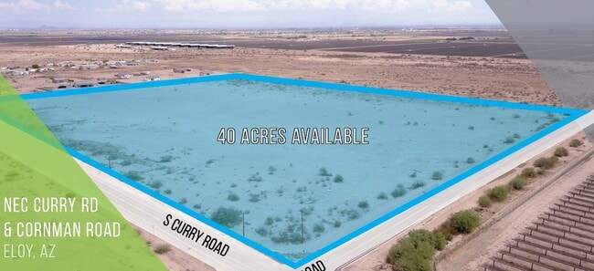
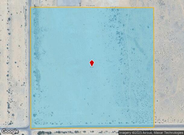
2950 W Cornman Rd
402-03-016
SW SW OF SEC 2-7S-7E EXC W-33 FOR R/W (1 AC TO R/W) 39.00 AC
Vacantlandnec
Pinal
X
Arizona
04021C1600E
39 AC
2024
Pinal County
2025
Phoenix
001200
Phoenix-Mesa-Scottsdale, AZ
DEMOGRAPHICS near 2950 W Cornman Rd
1 Mile
3 Mile
5 Mile
2024 Total Population
954
5,249
10,417
2029 Population
1,135
6,247
12,385
Pop Growth 2024-2029
+ 18.97%
+ 19.01%
+ 18.89%
Average Age
37
53
49
2024 Total Households
280
2,226
4,242
HH Growth 2024-2029
+ 18.57%
+ 18.87%
+ 18.72%
Median Household Inc
$39,999
$82,805
$74,730
Avg Household Size
2.90
2.30
2.40
2024 Avg HH Vehicles
2.00
2.00
2.00
Median Home Value
$267,105
$408,867
$385,209
Median Year Built
1995
2007
2006
Nearby Places
- Restaurants
- Banks
- Shops
- Fitness
- Groceries
Nearby Properties
Address
Land Use
TOTAL SIZE
Lot Size
Zoning
Address
Land Use
TOTAL SIZE
Lot Size
Zoning
33.69 AC
Address
Land Use
TOTAL SIZE
Lot Size
Zoning
30,877 SF
40 AC
GR
Address
Land Use
TOTAL SIZE
Lot Size
Zoning
116.28 AC
Address
Land Use
TOTAL SIZE
Lot Size
Zoning
2,906 SF
38.05 AC
Address
Land Use
TOTAL SIZE
Lot Size
Zoning
498.64 AC
Address
Land Use
TOTAL SIZE
Lot Size
Zoning
589.97 AC
Address
Land Use
TOTAL SIZE
Lot Size
Zoning
579.59 AC
Address
Land Use
TOTAL SIZE
Lot Size
Zoning
2,160 SF
80 AC
Address
Land Use
TOTAL SIZE
Lot Size
Zoning
Address
Land Use
TOTAL SIZE
Lot Size
Zoning
73.05 AC
Address
Land Use
TOTAL SIZE
Lot Size
Zoning
53.77 AC
UNDESIGNAT
Address
Land Use
TOTAL SIZE
Lot Size
Zoning
14,400 SF
40 AC
Address
Land Use
TOTAL SIZE
Lot Size
Zoning
50.97 AC
Address
Land Use
TOTAL SIZE
Lot Size
Zoning
54.59 AC
Address
Land Use
TOTAL SIZE
Lot Size
Zoning
28.93 AC
Address
Land Use
TOTAL SIZE
Lot Size
Zoning
29,516 SF
4.09 AC
Address
Land Use
TOTAL SIZE
Lot Size
Zoning
10,540 SF
3.78 AC
UNDESIGNAT
Address
Land Use
TOTAL SIZE
Lot Size
Zoning
21,027 SF
5.50 AC
Address
Land Use
TOTAL SIZE
Lot Size
Zoning
4,800 SF
4.07 AC
Address
Land Use
TOTAL SIZE
Lot Size
Zoning
9,464 SF
7.56 AC
GR
Address
Land Use
TOTAL SIZE
Lot Size
Zoning
5,564 SF
0.77 AC
UNDESIGNAT
Address
Land Use
TOTAL SIZE
Lot Size
Zoning
11,412 SF
4.09 AC
UNDESIGNAT
Address
Land Use
TOTAL SIZE
Lot Size
Zoning
9,144 SF
1.59 AC
UNDESIGNAT
Address
Land Use
TOTAL SIZE
Lot Size
Zoning
Address
Land Use
TOTAL SIZE
Lot Size
Zoning
2,196 SF
12.12 AC
Address
Land Use
TOTAL SIZE
Lot Size
Zoning
12,540 SF
5.57 AC
The World's #1 Commercial Real Estate Marketplace
Connect with us
© 2025 CoStar Group
The information above has been obtained from sources believed reliable. While we do not doubt its accuracy we have not verified it and make no guarantee, warranty or representation about it. It is your responsibility to independently confirm its accuracy and completeness. Any projections, opinions, assumptions, or estimates used are for example only and do not represent the current or future performance of the property. The value of this transaction to you depends on tax and other factors which should be evaluated by your tax, financial, and legal advisors. You and your advisors should conduct a careful, independent investigation of the property to determine to your satisfaction the suitability of the property for your needs.