Property Record
W Interstate Highway 40, Amarillo, TX 79124
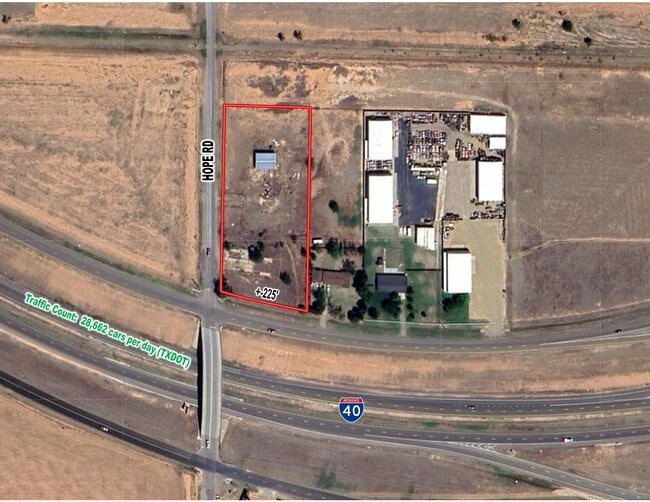

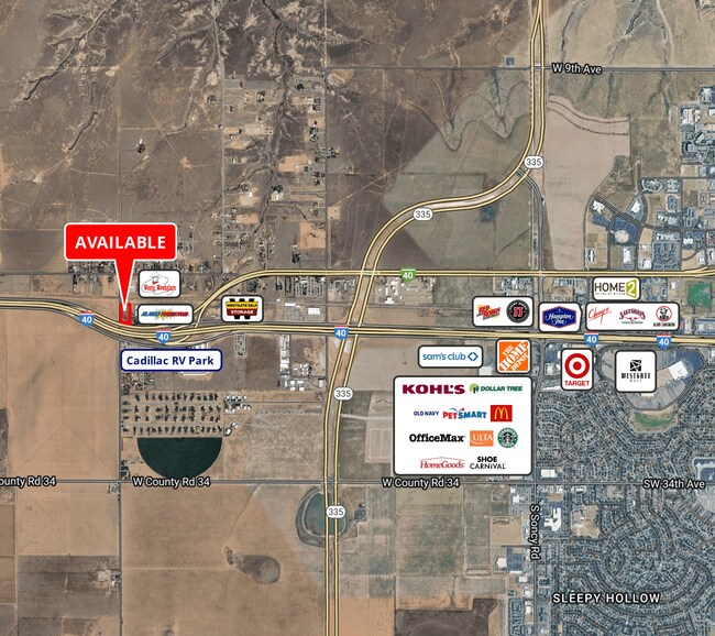
This Property Is For Sale
Property Detail
W Interstate Highway 40
Amarillo, TX
B S & F
R-370-0760-8000-0
SECT 76 B S & F BLK 0009, 2.55 ACS BEG 774.64FT S & 30.1FT E OF NW COR OF SECT, 2.5500 ACRES
Commercialnec
Potter
X
Texas
48375C0505C
2.55 AC
2024
Amarillo
2025
Other Market Areas
014300
NEARBY LISTINGS FOR SALE OR LEASE
DEMOGRAPHICS near W Interstate Highway 40
1 mile
3 mile
5 mile
2024 Total Population
493
6,655
59,929
2029 Population
523
7,042
63,166
Pop Growth 2024-2029
+ 6.09%
+ 5.82%
+ 5.40%
Average Age
38
42
41
2024 Total Households
165
2,738
24,945
HH Growth 2024-2029
+ 6.06%
+ 5.62%
+ 5.37%
Median Household Inc
$119,140
$89,549
$78,371
Avg Household Size
2.90
2.30
2.30
2024 Avg HH Vehicles
3.00
2.00
2.00
Median Home Value
$294,999
$224,953
$224,781
Median Year Built
2010
1987
1985
Nearby Places
Map Layers
Map Styles
 Street
 Aerial
Transit
 Traffic
 Biking
Places
Listings with unknown addresses are not visible on the map
- Restaurants
- Banks
- Shops
- Fitness
- Groceries
PUBLIC TRANSPORTATION
AIRPORT
Rick Husband Amarillo International
Drive
Walk
Distance
Rick Husband Amarillo International
24 min
17.0 mi
Freight Ports
Tulsa Port Of Catoosa
Drive
Walk
Distance
Tulsa Port Of Catoosa
406 min
385.0 mi
Nearby Properties
Address
Land Use
TOTAL SIZE
Lot Size
Zoning
Address
Land Use
TOTAL SIZE
Lot Size
Zoning
343,998 SF
19.99 AC
PD
Address
Land Use
TOTAL SIZE
Lot Size
Zoning
202,800 SF
6.57 AC
Address
Land Use
TOTAL SIZE
Lot Size
Zoning
270,379 SF
12.12 AC
Address
Land Use
TOTAL SIZE
Lot Size
Zoning
485,065 SF
38.89 AC
Address
Land Use
TOTAL SIZE
Lot Size
Zoning
485,065 SF
38.89 AC
Address
Land Use
TOTAL SIZE
Lot Size
Zoning
145,819 SF
12.89 AC
PD
Address
Land Use
TOTAL SIZE
Lot Size
Zoning
52,473 SF
5.67 AC
Address
Land Use
TOTAL SIZE
Lot Size
Zoning
100,099 SF
3 AC
HC
Address
Land Use
TOTAL SIZE
Lot Size
Zoning
54,653 SF
5.45 AC
Address
Land Use
TOTAL SIZE
Lot Size
Zoning
49,647 SF
3.67 AC
Address
Land Use
TOTAL SIZE
Lot Size
Zoning
89,173 SF
9.55 AC
PD
Address
Land Use
TOTAL SIZE
Lot Size
Zoning
69,009 SF
37.97 AC
Address
Land Use
TOTAL SIZE
Lot Size
Zoning
96,538 SF
11.33 AC
PD
Address
Land Use
TOTAL SIZE
Lot Size
Zoning
204,310 SF
12.50 AC
A
Address
Land Use
TOTAL SIZE
Lot Size
Zoning
73,558 SF
3.09 AC
Address
Land Use
TOTAL SIZE
Lot Size
Zoning
139,360 SF
77.61 AC
Address
Land Use
TOTAL SIZE
Lot Size
Zoning
70,837 SF
10 AC
R2
Address
Land Use
TOTAL SIZE
Lot Size
Zoning
78,465 SF
14.42 AC
GR
Address
Land Use
TOTAL SIZE
Lot Size
Zoning
69,100 SF
11.93 AC
Address
Land Use
TOTAL SIZE
Lot Size
Zoning
160,224 SF
11.32 AC
PD
Address
Land Use
TOTAL SIZE
Lot Size
Zoning
41,600 SF
10.39 AC
Address
Land Use
TOTAL SIZE
Lot Size
Zoning
64,862 SF
5.92 AC
Address
Land Use
TOTAL SIZE
Lot Size
Zoning
64,129 SF
1.79 AC
HC
Address
Land Use
TOTAL SIZE
Lot Size
Zoning
67,930 SF
4.20 AC
Address
Land Use
TOTAL SIZE
Lot Size
Zoning
89,713 SF
11.20 AC
PO
Address
Land Use
TOTAL SIZE
Lot Size
Zoning
138,512 SF
17.38 AC
Address
Land Use
TOTAL SIZE
Lot Size
Zoning
33,664 SF
5.30 AC
O
Address
Land Use
TOTAL SIZE
Lot Size
Zoning
53,744 SF
3.13 AC
Address
Land Use
TOTAL SIZE
Lot Size
Zoning
45,769 SF
4.90 AC
Address
Land Use
TOTAL SIZE
Lot Size
Zoning
113,625 SF
5.06 AC
O
The World's #1 Commercial Real Estate Marketplace
Connect with us
© 2026 CoStar Group
The information above has been obtained from sources believed reliable. While we do not doubt its accuracy we have not verified it and make no guarantee, warranty or representation about it. It is your responsibility to independently confirm its accuracy and completeness. Any projections, opinions, assumptions, or estimates used are for example only and do not represent the current or future performance of the property. The value of this transaction to you depends on tax and other factors which should be evaluated by your tax, financial, and legal advisors. You and your advisors should conduct a careful, independent investigation of the property to determine to your satisfaction the suitability of the property for your needs.