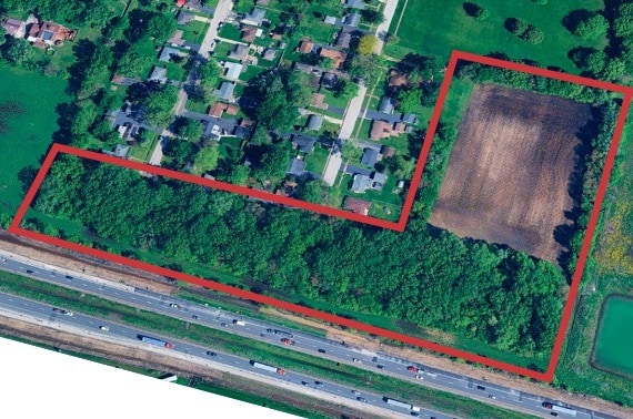
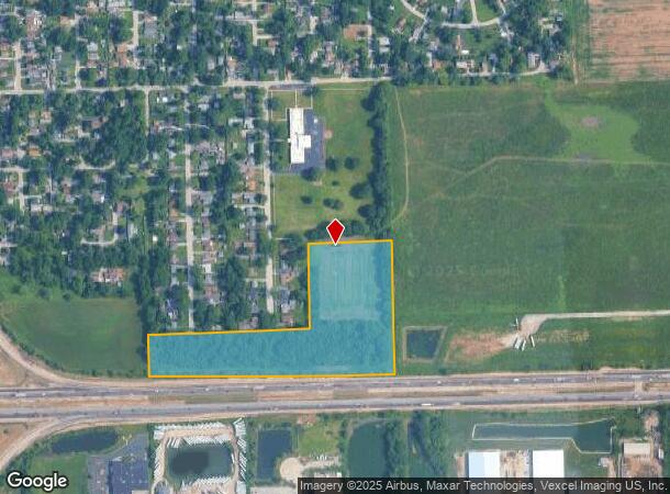
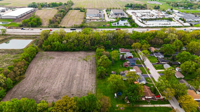
Property Record
New Lenox Rd, Joliet, IL 60433
Current Lease Availabilities
NEARBY LISTINGS FOR SALE OR LEASE
Property Detail
New Lenox Rd
Chicago-Naperville-Elgin, IL-IN-WI
River Hills Ph 3
30-07-13-311-020
TRACT 2 THE E1/2 OF THE SW1/4 OF SEC 13,T35N-R10E, LYING N'LY OF THE N'LY ROW LINE OF STATE OF ILLINOIS FAI RTE 80 AS SHOWN O
Agriculturalland
Will
X
Illinois
17197C0170G
12.28 AC
2024
Joliet/Central Will
2024
Chicago
883000
DEMOGRAPHICS near New Lenox Rd
1 Mile
3 Mile
5 Mile
2024 Total Population
5,378
48,124
132,867
2029 Population
5,499
49,303
135,628
Pop Growth 2024-2029
+ 2.25%
+ 2.45%
+ 2.08%
Average Age
39
38
38
2024 Total Households
1,855
16,044
45,699
HH Growth 2024-2029
+ 2.26%
+ 2.51%
+ 2.13%
Median Household Inc
$56,404
$56,680
$68,699
Avg Household Size
2.70
2.80
2.70
2024 Avg HH Vehicles
2.00
2.00
2.00
Median Home Value
$135,971
$173,750
$214,794
Median Year Built
1954
1962
1966
Nearby Places
- Restaurants
- Banks
- Shops
- Fitness
- Groceries
PUBLIC TRANSPORTATION
COMMUTER RAIL
Joliet Station (Heritage Corridor Line - Northeast Illinois Regional Commuter Railroad (Metra), Rock Island District Line - Northeast Illinois Regional Commuter Railroad (Metra))
DRIVE
WALK
Distance
Joliet Station (Heritage Corridor Line - Northeast Illinois Regional Commuter Railroad (Metra), Rock Island District Line - Northeast Illinois Regional Commuter Railroad (Metra))
8 min
2.8 mi
New Lenox Station (Rock Island District Line - Northeast Illinois Regional Commuter Railroad (Metra))
DRIVE
WALK
Distance
New Lenox Station (Rock Island District Line - Northeast Illinois Regional Commuter Railroad (Metra))
11 min
4.4 mi
AIRPORT
Chicago Midway International
DRIVE
WALK
Distance
Chicago Midway International
48 min
33.9 mi
Freight Ports
Port Milwaukee
DRIVE
WALK
Distance
Port Milwaukee
146 min
117.0 mi
Nearby Properties
Address
Land Use
TOTAL SIZE
Lot Size
Zoning
Address
Land Use
TOTAL SIZE
Lot Size
Zoning
27.63 AC
Address
Land Use
TOTAL SIZE
Lot Size
Zoning
2.19 AC
Address
Land Use
TOTAL SIZE
Lot Size
Zoning
67.82 AC
Address
Land Use
TOTAL SIZE
Lot Size
Zoning
53.05 AC
Address
Land Use
TOTAL SIZE
Lot Size
Zoning
59.92 AC
Address
Land Use
TOTAL SIZE
Lot Size
Zoning
128.88 AC
Address
Land Use
TOTAL SIZE
Lot Size
Zoning
45.09 AC
Address
Land Use
TOTAL SIZE
Lot Size
Zoning
34.48 AC
Address
Land Use
TOTAL SIZE
Lot Size
Zoning
52.25 AC
Address
Land Use
TOTAL SIZE
Lot Size
Zoning
26.04 AC
Address
Land Use
TOTAL SIZE
Lot Size
Zoning
36.54 AC
Address
Land Use
TOTAL SIZE
Lot Size
Zoning
17.49 AC
Address
Land Use
TOTAL SIZE
Lot Size
Zoning
30.99 AC
Address
Land Use
TOTAL SIZE
Lot Size
Zoning
22.77 AC
Address
Land Use
TOTAL SIZE
Lot Size
Zoning
Address
Land Use
TOTAL SIZE
Lot Size
Zoning
20.66 AC
Address
Land Use
TOTAL SIZE
Lot Size
Zoning
38.40 AC
Address
Land Use
TOTAL SIZE
Lot Size
Zoning
12.03 AC
Address
Land Use
TOTAL SIZE
Lot Size
Zoning
13.14 AC
Address
Land Use
TOTAL SIZE
Lot Size
Zoning
10.28 AC
Address
Land Use
TOTAL SIZE
Lot Size
Zoning
16.31 AC
Address
Land Use
TOTAL SIZE
Lot Size
Zoning
3.40 AC
Address
Land Use
TOTAL SIZE
Lot Size
Zoning
19.41 AC
Address
Land Use
TOTAL SIZE
Lot Size
Zoning
11.57 AC
Address
Land Use
TOTAL SIZE
Lot Size
Zoning
8.79 AC
Address
Land Use
TOTAL SIZE
Lot Size
Zoning
Address
Land Use
TOTAL SIZE
Lot Size
Zoning
1.71 AC
Address
Land Use
TOTAL SIZE
Lot Size
Zoning
2.69 AC
Address
Land Use
TOTAL SIZE
Lot Size
Zoning
12 AC
Address
Land Use
TOTAL SIZE
Lot Size
Zoning
2.06 AC
The World's #1 Commercial Real Estate Marketplace
Connect with us
© 2025 CoStar Group
The information above has been obtained from sources believed reliable. While we do not doubt its accuracy we have not verified it and make no guarantee, warranty or representation about it. It is your responsibility to independently confirm its accuracy and completeness. Any projections, opinions, assumptions, or estimates used are for example only and do not represent the current or future performance of the property. The value of this transaction to you depends on tax and other factors which should be evaluated by your tax, financial, and legal advisors. You and your advisors should conduct a careful, independent investigation of the property to determine to your satisfaction the suitability of the property for your needs.