Property Record
17818 W Kelso Dr, Waddell, AZ 85355
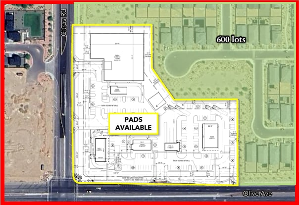
Current Lease Availabilities
NEARBY LISTINGS FOR SALE OR LEASE
Property Detail
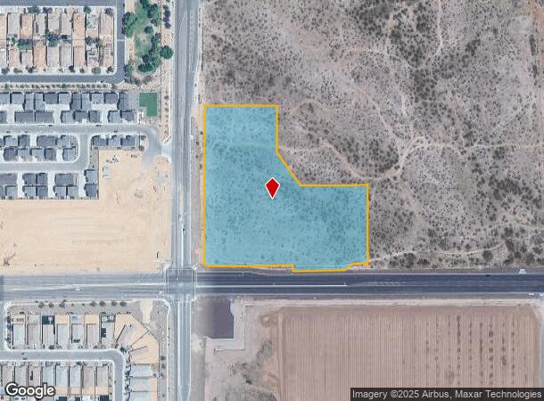
17818 W Kelso Dr
Phoenix-Mesa-Scottsdale, AZ
Zanjero Pass Parcel 1-3 Phase 2-4
502-83-151B
ZANJERO PASS PARCEL 1-3 PHASE 2-4 MCR 979-26
Commercialacreage
Maricopa
X
Arizona
04013C1655L
2
2025
6.02 AC
2025
Loop 303/Surprise
061044
Phoenix
DEMOGRAPHICS near 17818 W Kelso Dr
1 Mile
3 Mile
5 Mile
2024 Total Population
8,640
29,763
99,377
2029 Population
9,631
33,371
109,210
Pop Growth 2024-2029
+ 11.47%
+ 12.12%
+ 9.89%
Average Age
36
37
37
2024 Total Households
2,610
9,022
30,570
HH Growth 2024-2029
+ 11.61%
+ 12.27%
+ 10.04%
Median Household Inc
$95,910
$105,221
$100,353
Avg Household Size
3.20
3.20
3.10
2024 Avg HH Vehicles
2.00
3.00
2.00
Median Home Value
$374,976
$413,123
$393,611
Median Year Built
2009
2010
2007
Nearby Places
Map Layers
Map Styles
 Street
 Aerial
- Restaurants
- Banks
- Shops
- Fitness
- Groceries
PUBLIC TRANSPORTATION
AIRPORT
Phoenix Sky Harbor International
DRIVE
WALK
Distance
Phoenix Sky Harbor International
47 min
35.5 mi
Freight Ports
Port of San Diego
DRIVE
WALK
Distance
Port of San Diego
381 min
340.4 mi
Nearby Properties
Address
Land Use
TOTAL SIZE
Lot Size
Zoning
Address
Land Use
TOTAL SIZE
Lot Size
Zoning
283,614 SF
55.80 AC
PAD
Address
Land Use
TOTAL SIZE
Lot Size
Zoning
1,758,410 SF
98.58 AC
PAD
Address
Land Use
TOTAL SIZE
Lot Size
Zoning
915,160 SF
53.89 AC
Address
Land Use
TOTAL SIZE
Lot Size
Zoning
1,259,666 SF
71.73 AC
R-43
Address
Land Use
TOTAL SIZE
Lot Size
Zoning
1,109,869 SF
67.32 AC
R-43
Address
Land Use
TOTAL SIZE
Lot Size
Zoning
1,178,814 SF
64.63 AC
Address
Land Use
TOTAL SIZE
Lot Size
Zoning
522,480 SF
31.89 AC
Address
Land Use
TOTAL SIZE
Lot Size
Zoning
897,328 SF
53.70 AC
Address
Land Use
TOTAL SIZE
Lot Size
Zoning
216,334 SF
55.45 AC
R16
Address
Land Use
TOTAL SIZE
Lot Size
Zoning
20.79 AC
Address
Land Use
TOTAL SIZE
Lot Size
Zoning
349,633 SF
23.03 AC
Address
Land Use
TOTAL SIZE
Lot Size
Zoning
210,197 SF
19.40 AC
RH15
Address
Land Use
TOTAL SIZE
Lot Size
Zoning
797,969 SF
66.20 AC
PAD
Address
Land Use
TOTAL SIZE
Lot Size
Zoning
102,295 SF
12.58 AC
R-6
Address
Land Use
TOTAL SIZE
Lot Size
Zoning
905,330 SF
88.90 AC
PAD
Address
Land Use
TOTAL SIZE
Lot Size
Zoning
365,373 SF
36.18 AC
Address
Land Use
TOTAL SIZE
Lot Size
Zoning
172,273 SF
29.79 AC
RU43
Address
Land Use
TOTAL SIZE
Lot Size
Zoning
175,760 SF
12.93 AC
Address
Land Use
TOTAL SIZE
Lot Size
Zoning
46,424 SF
10 AC
PAD
Address
Land Use
TOTAL SIZE
Lot Size
Zoning
143,451 SF
35.12 AC
Address
Land Use
TOTAL SIZE
Lot Size
Zoning
82,692 SF
9.85 AC
CR
Address
Land Use
TOTAL SIZE
Lot Size
Zoning
61,000 SF
6.50 AC
Address
Land Use
TOTAL SIZE
Lot Size
Zoning
170,212 SF
8.90 AC
PAD
Address
Land Use
TOTAL SIZE
Lot Size
Zoning
38,615 SF
7.59 AC
PAD
Address
Land Use
TOTAL SIZE
Lot Size
Zoning
144,156 SF
14.75 AC
I-1
Address
Land Use
TOTAL SIZE
Lot Size
Zoning
50,224 SF
12 AC
PAD
Address
Land Use
TOTAL SIZE
Lot Size
Zoning
63,240 SF
5.19 AC
Address
Land Use
TOTAL SIZE
Lot Size
Zoning
32,512 SF
5.84 AC
PAD
Address
Land Use
TOTAL SIZE
Lot Size
Zoning
157.47 AC
R-43
The World's #1 Commercial Real Estate Marketplace
Connect with us
© 2026 CoStar Group
The information above has been obtained from sources believed reliable. While we do not doubt its accuracy we have not verified it and make no guarantee, warranty or representation about it. It is your responsibility to independently confirm its accuracy and completeness. Any projections, opinions, assumptions, or estimates used are for example only and do not represent the current or future performance of the property. The value of this transaction to you depends on tax and other factors which should be evaluated by your tax, financial, and legal advisors. You and your advisors should conduct a careful, independent investigation of the property to determine to your satisfaction the suitability of the property for your needs.