Property Record
N Estrella Pkwy, Maricopa, AZ 85139
NEARBY LISTINGS FOR SALE OR LEASE
Property Detail
N Estrella Pkwy
Phoenix
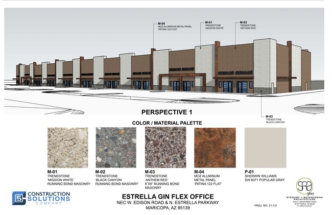
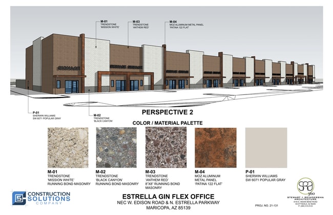
A PORTION OF PARCEL 1 OF THE AMENDED FINAL PLAT OF ESTRELLA GIN B UISNESS PARK, ACCORDING TO THE PLAT OF RECORD IN THE OFFICE OF TH E COUNTY RECORDER OF PINAL COUNTY, ARIZONA, RECORDED IN FEE NO. 2 019-073078, LOCATED IN SOUTHEAST QUARTER OF THE NORT
Phoenix-Mesa-Scottsdale, AZ
Pinal
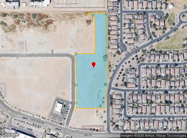
510-17-021F
Arizona
Vacantlandnec
5.83 AC
2024
Pinal County
2025
DEMOGRAPHICS near N Estrella Pkwy
1 Mile
3 Mile
5 Mile
2024 Total Population
5,913
49,683
60,186
2029 Population
7,395
62,722
76,012
Pop Growth 2024-2029
+ 25.06%
+ 26.24%
+ 26.30%
Average Age
36
38
38
2024 Total Households
1,858
16,349
19,738
HH Growth 2024-2029
+ 24.65%
+ 26.07%
+ 26.15%
Median Household Inc
$83,967
$92,254
$90,854
Avg Household Size
3.10
3.00
3.00
2024 Avg HH Vehicles
2.00
2.00
2.00
Median Home Value
$263,960
$326,206
$327,613
Median Year Built
2004
2006
2006
Nearby Places
- Restaurants
- Banks
- Shops
- Fitness
- Groceries
PUBLIC TRANSPORTATION
COMMUTER RAIL
Maricopa (Sunset Limited - Amtrak, Texas Eagle - Amtrak)
DRIVE
WALK
Distance
Maricopa (Sunset Limited - Amtrak, Texas Eagle - Amtrak)
2 min
1.3 mi
AIRPORT
Phoenix Sky Harbor International
DRIVE
WALK
Distance
Phoenix Sky Harbor International
43 min
30.0 mi
Phoenix-Mesa Gateway
DRIVE
WALK
Distance
Phoenix-Mesa Gateway
51 min
35.0 mi
Freight Ports
Port of San Diego
DRIVE
WALK
Distance
Port of San Diego
368 min
341.4 mi
SALE & LEASE HISTORY
LISTING DATE
SALE/LEASE

Apr 07, 2023
For Sale
Nearby Properties
Address
Land Use
TOTAL SIZE
Lot Size
Zoning
Address
Land Use
TOTAL SIZE
Lot Size
Zoning
102,212 SF
11.98 AC
Address
Land Use
TOTAL SIZE
Lot Size
Zoning
78,634 SF
7.83 AC
Address
Land Use
TOTAL SIZE
Lot Size
Zoning
57,070 SF
9.05 AC
Address
Land Use
TOTAL SIZE
Lot Size
Zoning
92,929 SF
11.43 AC
Address
Land Use
TOTAL SIZE
Lot Size
Zoning
12.02 AC
UNDESIGNAT
Address
Land Use
TOTAL SIZE
Lot Size
Zoning
38,215 SF
9.84 AC
Address
Land Use
TOTAL SIZE
Lot Size
Zoning
20,801 SF
1.94 AC
Address
Land Use
TOTAL SIZE
Lot Size
Zoning
39,454 SF
5 AC
Address
Land Use
TOTAL SIZE
Lot Size
Zoning
83,747 SF
5.01 AC
Address
Land Use
TOTAL SIZE
Lot Size
Zoning
134,977 SF
4.53 AC
Address
Land Use
TOTAL SIZE
Lot Size
Zoning
124,122 SF
2.38 AC
Address
Land Use
TOTAL SIZE
Lot Size
Zoning
Address
Land Use
TOTAL SIZE
Lot Size
Zoning
38,864 SF
5.38 AC
Address
Land Use
TOTAL SIZE
Lot Size
Zoning
25,287 SF
2.72 AC
UNDESIGNAT
Address
Land Use
TOTAL SIZE
Lot Size
Zoning
26.11 AC
Address
Land Use
TOTAL SIZE
Lot Size
Zoning
13.31 AC
UNDESIGNAT
Address
Land Use
TOTAL SIZE
Lot Size
Zoning
51,440 SF
4.99 AC
Address
Land Use
TOTAL SIZE
Lot Size
Zoning
19,650 SF
317.62 AC
UNDESIGNAT
Address
Land Use
TOTAL SIZE
Lot Size
Zoning
Address
Land Use
TOTAL SIZE
Lot Size
Zoning
23,920 SF
2.55 AC
Address
Land Use
TOTAL SIZE
Lot Size
Zoning
Address
Land Use
TOTAL SIZE
Lot Size
Zoning
9,060 SF
1.04 AC
Address
Land Use
TOTAL SIZE
Lot Size
Zoning
12,696 SF
4.89 AC
Address
Land Use
TOTAL SIZE
Lot Size
Zoning
11,160 SF
1.45 AC
Address
Land Use
TOTAL SIZE
Lot Size
Zoning
14,866 SF
1.73 AC
UNDESIGNAT
The World's #1 Commercial Real Estate Marketplace
Connect with us
© 2025 CoStar Group
The information above has been obtained from sources believed reliable. While we do not doubt its accuracy we have not verified it and make no guarantee, warranty or representation about it. It is your responsibility to independently confirm its accuracy and completeness. Any projections, opinions, assumptions, or estimates used are for example only and do not represent the current or future performance of the property. The value of this transaction to you depends on tax and other factors which should be evaluated by your tax, financial, and legal advisors. You and your advisors should conduct a careful, independent investigation of the property to determine to your satisfaction the suitability of the property for your needs.