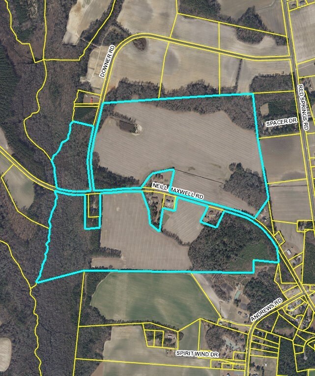
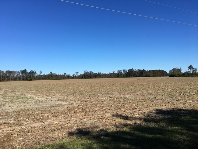
Property Record
Neil Maxwell Rd, Raeford, NC 28376

Property Detail
Neil Maxwell Rd
Fayetteville, NC
SCARBORO 4-159/2 314/929 HOUSE GONE FOR 2004 RAFT SWAMP/MCLEOD
694330001061
HOKE
Residentialacreage
North Carolina
AE The base floodplain where base flood elevations are provided. AE Zones are now used on new format FIRMs instead of A1-A30 Zones.
233.08 AC
2025
Hoke County
2025
Fayetteville
970107
NEARBY LISTINGS FOR SALE OR LEASE
-
-
View all Raeford listings for sale on LoopNet.com
DEMOGRAPHICS near Neil Maxwell Rd
1 mile
3 mile
5 mile
2025 Total Population
199
3,746
14,416
2030 Population
211
3,930
15,191
Pop Growth 2025-2030
+ 6.03%
+ 4.91%
+ 5.38%
Average Age
38
39
38
2025 Total Households
72
1,388
5,336
HH Growth 2025-2030
+ 5.56%
+ 4.90%
+ 5.49%
Median Household Inc
$48,749
$41,968
$46,527
Avg Household Size
2.80
2.60
2.60
2025 Avg HH Vehicles
2.00
2.00
2.00
Median Home Value
$99,999
$124,350
$160,766
Median Year Built
1993
1988
1989
Nearby Places
Map Layers
Map Styles
 Street
 Aerial
Layers
 Traffic
 Biking
Places
Listings with unknown addresses are not visible on the map
- Restaurants
- Banks
- Shops
- Fitness
- Groceries
PUBLIC TRANSPORTATION
AIRPORT
Fayetteville Regional/Grannis Field
Drive
Walk
Distance
Fayetteville Regional/Grannis Field
41 min
26.1 mi
Freight Ports
Port of Wilmington
Drive
Walk
Distance
Port of Wilmington
149 min
112.1 mi
SALE & LEASE HISTORY
LISTING DATE
SALE/LEASE

Mar 03, 2020
For Sale
Nearby Properties
Address
Land Use
TOTAL SIZE
Lot Size
Zoning
Address
Land Use
TOTAL SIZE
Lot Size
Zoning
236 SF
60.37 AC
Address
Land Use
TOTAL SIZE
Lot Size
Zoning
1,867 SF
54.94 AC
Address
Land Use
TOTAL SIZE
Lot Size
Zoning
1,022 SF
52.78 AC
Address
Land Use
TOTAL SIZE
Lot Size
Zoning
282 SF
1.86 AC
Address
Land Use
TOTAL SIZE
Lot Size
Zoning
742 SF
20.04 AC
Address
Land Use
TOTAL SIZE
Lot Size
Zoning
724 SF
35 AC
Address
Land Use
TOTAL SIZE
Lot Size
Zoning
276 SF
0.98 AC
Address
Land Use
TOTAL SIZE
Lot Size
Zoning
76,774 SF
8.76 AC
Address
Land Use
TOTAL SIZE
Lot Size
Zoning
640 SF
18.55 AC
Address
Land Use
TOTAL SIZE
Lot Size
Zoning
15,328 SF
0.14 AC
Address
Land Use
TOTAL SIZE
Lot Size
Zoning
16,632 SF
0.61 AC
Address
Land Use
TOTAL SIZE
Lot Size
Zoning
1,006 SF
15.73 AC
Address
Land Use
TOTAL SIZE
Lot Size
Zoning
390 AC
Address
Land Use
TOTAL SIZE
Lot Size
Zoning
160 SF
91.35 AC
Address
Land Use
TOTAL SIZE
Lot Size
Zoning
4,504 SF
1.15 AC
Address
Land Use
TOTAL SIZE
Lot Size
Zoning
420 SF
11.73 AC
Address
Land Use
TOTAL SIZE
Lot Size
Zoning
11,000 SF
33.41 AC
Address
Land Use
TOTAL SIZE
Lot Size
Zoning
8,943 SF
0.51 AC
Address
Land Use
TOTAL SIZE
Lot Size
Zoning
14,260 SF
0.21 AC
Address
Land Use
TOTAL SIZE
Lot Size
Zoning
15,358 SF
0.48 AC
Address
Land Use
TOTAL SIZE
Lot Size
Zoning
17,004 SF
1.45 AC
Address
Land Use
TOTAL SIZE
Lot Size
Zoning
13,501 SF
1.23 AC
Address
Land Use
TOTAL SIZE
Lot Size
Zoning
806.80 AC
Address
Land Use
TOTAL SIZE
Lot Size
Zoning
8,714 SF
0.34 AC
Address
Land Use
TOTAL SIZE
Lot Size
Zoning
346 SF
1.32 AC
Address
Land Use
TOTAL SIZE
Lot Size
Zoning
2,136 SF
1.05 AC
Address
Land Use
TOTAL SIZE
Lot Size
Zoning
3,518 SF
1.03 AC
Address
Land Use
TOTAL SIZE
Lot Size
Zoning
5,392 SF
2.32 AC
Address
Land Use
TOTAL SIZE
Lot Size
Zoning
180 SF
10.72 AC
Address
Land Use
TOTAL SIZE
Lot Size
Zoning
9,672 SF
1.22 AC
The World's #1 Commercial Real Estate Marketplace
Connect with us
© 2026 CoStar Group
The information above has been obtained from sources believed reliable. While we do not doubt its accuracy we have not verified it and make no guarantee, warranty or representation about it. It is your responsibility to independently confirm its accuracy and completeness. Any projections, opinions, assumptions, or estimates used are for example only and do not represent the current or future performance of the property. The value of this transaction to you depends on tax and other factors which should be evaluated by your tax, financial, and legal advisors. You and your advisors should conduct a careful, independent investigation of the property to determine to your satisfaction the suitability of the property for your needs.