Property Record
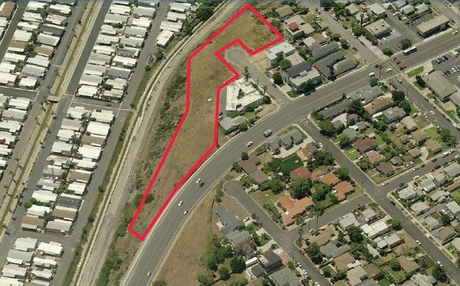
Nevada St, Oceanside, CA 92054

Property Detail
Nevada St
San Diego-Chula Vista-Carlsbad, CA
TCT 101 POR TR 000622
152-121-06
SAN DIEGO
Residentialacreage
California
R-3
7
B and X Area of moderate flood hazard, usually the area between the limits of the 100-year and 500-year floods.
0.96 AC
2024
Oceanside
2025
San Diego
018509
NEARBY LISTINGS FOR SALE OR LEASE
DEMOGRAPHICS near Nevada St
1 mile
3 mile
5 mile
2024 Total Population
17,035
84,679
174,796
2029 Population
17,389
86,135
176,692
Pop Growth 2024-2029
+ 2.08%
+ 1.72%
+ 1.08%
Average Age
41
39
40
2024 Total Households
7,212
32,645
63,964
HH Growth 2024-2029
+ 2.26%
+ 1.98%
+ 1.25%
Median Household Inc
$87,260
$86,682
$94,055
Avg Household Size
2.30
2.40
2.50
2024 Avg HH Vehicles
2.00
2.00
2.00
Median Home Value
$1,011,648
$943,741
$849,227
Median Year Built
1971
1977
1982
Nearby Places
Map Layers
Map Styles
 Street
 Aerial
Transit
 Traffic
 Biking
Places
Listings with unknown addresses are not visible on the map
- Restaurants
- Banks
- Shops
- Fitness
- Groceries
PUBLIC TRANSPORTATION
TRANSIT/SUBWAY
Coast Highway (Sprinter - San Diego North County Transit District (Coaster/Sprinter/Breeze))
Drive
Walk
Distance
Coast Highway (Sprinter - San Diego North County Transit District (Coaster/Sprinter/Breeze))
1 min
8 min
0.4 mi
Crouch Street (Sprinter - San Diego North County Transit District (Coaster/Sprinter/Breeze))
Drive
Walk
Distance
Crouch Street (Sprinter - San Diego North County Transit District (Coaster/Sprinter/Breeze))
3 min
20 min
1.1 mi
COMMUTER RAIL
Oceanside Transit Center (Metrolink Inland Empire-Orange County Line - Metrolink Trains, Metrolink Orange County Line - Metrolink Trains, Orange County Line - Metrolink Trains)
Drive
Walk
Distance
Oceanside Transit Center (Metrolink Inland Empire-Orange County Line - Metrolink Trains, Metrolink Orange County Line - Metrolink Trains, Orange County Line - Metrolink Trains)
4 min
1.4 mi
Carlsbad Village (Coaster - San Diego North County Transit District (Coaster/Sprinter/Breeze))
Drive
Walk
Distance
Carlsbad Village (Coaster - San Diego North County Transit District (Coaster/Sprinter/Breeze))
6 min
2.2 mi
Freight Ports
Port of San Diego
Drive
Walk
Distance
Port of San Diego
50 min
39.7 mi
Nearby Properties
Address
Land Use
TOTAL SIZE
Lot Size
Zoning
Address
Land Use
TOTAL SIZE
Lot Size
Zoning
1.38 AC
C
Address
Land Use
TOTAL SIZE
Lot Size
Zoning
5.28 AC
C2
Address
Land Use
TOTAL SIZE
Lot Size
Zoning
16 AC
P-C
Address
Land Use
TOTAL SIZE
Lot Size
Zoning
1.38 AC
C
Address
Land Use
TOTAL SIZE
Lot Size
Zoning
4.26 AC
C-2
Address
Land Use
TOTAL SIZE
Lot Size
Zoning
1.77 AC
C-2
Address
Land Use
TOTAL SIZE
Lot Size
Zoning
1.14 AC
C
Address
Land Use
TOTAL SIZE
Lot Size
Zoning
85,000 SF
4.40 AC
CC
Address
Land Use
TOTAL SIZE
Lot Size
Zoning
19.51 AC
C-2-Q
Address
Land Use
TOTAL SIZE
Lot Size
Zoning
10.63 AC
RD-M
Address
Land Use
TOTAL SIZE
Lot Size
Zoning
1.02 AC
D-1
Address
Land Use
TOTAL SIZE
Lot Size
Zoning
2.30 AC
V-R
Address
Land Use
TOTAL SIZE
Lot Size
Zoning
4.68 AC
D-6B
Address
Land Use
TOTAL SIZE
Lot Size
Zoning
6.63 AC
RD-M
Address
Land Use
TOTAL SIZE
Lot Size
Zoning
57,905 SF
2.16 AC
R-3
Address
Land Use
TOTAL SIZE
Lot Size
Zoning
1.34 AC
V-B
Address
Land Use
TOTAL SIZE
Lot Size
Zoning
64,722 SF
2.17 AC
D-1
Address
Land Use
TOTAL SIZE
Lot Size
Zoning
6,024 SF
6.92 AC
VC
Address
Land Use
TOTAL SIZE
Lot Size
Zoning
92,481 SF
9.53 AC
CG-PBD
Address
Land Use
TOTAL SIZE
Lot Size
Zoning
9.59 AC
RD-M-Q
Address
Land Use
TOTAL SIZE
Lot Size
Zoning
59,587 SF
0.69 AC
V-R
Address
Land Use
TOTAL SIZE
Lot Size
Zoning
68,630 SF
1.30 AC
C-2
Address
Land Use
TOTAL SIZE
Lot Size
Zoning
96,942 SF
4.49 AC
R-3
Address
Land Use
TOTAL SIZE
Lot Size
Zoning
66,816 SF
9.55 AC
RH
Address
Land Use
TOTAL SIZE
Lot Size
Zoning
9.52 AC
CS-HO
Address
Land Use
TOTAL SIZE
Lot Size
Zoning
10.15 AC
P-C
Address
Land Use
TOTAL SIZE
Lot Size
Zoning
2.67 AC
C-6
Address
Land Use
TOTAL SIZE
Lot Size
Zoning
80,720 SF
0.90 AC
C
Address
Land Use
TOTAL SIZE
Lot Size
Zoning
70,000 SF
1.75 AC
V-R
Address
Land Use
TOTAL SIZE
Lot Size
Zoning
16.32 AC
PD-3
The World's #1 Commercial Real Estate Marketplace
Connect with us
© 2026 CoStar Group
The information above has been obtained from sources believed reliable. While we do not doubt its accuracy we have not verified it and make no guarantee, warranty or representation about it. It is your responsibility to independently confirm its accuracy and completeness. Any projections, opinions, assumptions, or estimates used are for example only and do not represent the current or future performance of the property. The value of this transaction to you depends on tax and other factors which should be evaluated by your tax, financial, and legal advisors. You and your advisors should conduct a careful, independent investigation of the property to determine to your satisfaction the suitability of the property for your needs.